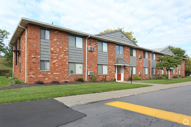
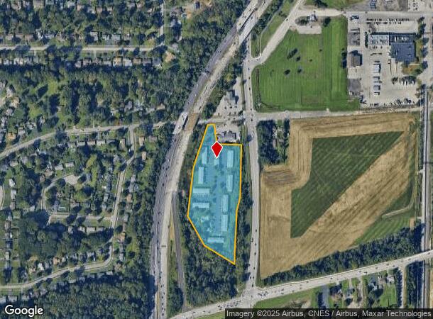
Property Record
725 Weiland Rd, Rochester, NY 14626
NEARBY LISTINGS FOR SALE OR LEASE
Property Detail
725 Weiland Rd
262800-089-120-0001-003-000
20TR L97,98 T1
Apartment
Monroe
X
New York
36055C0183G
3.000
2025
7.50 AC
2024
Outer Greece/Northwest Monroe County
013505
Rochester
9,360 SF
Rochester, NY
DEMOGRAPHICS near 725 Weiland Rd
1 Mile
3 Mile
5 Mile
2024 Total Population
3,608
90,299
254,162
2029 Population
3,508
88,877
250,485
Pop Growth 2024-2029
(2.77%)
(1.57%)
(1.45%)
Average Age
44
40
40
2024 Total Households
1,499
38,426
106,809
HH Growth 2024-2029
(2.80%)
(1.63%)
(1.46%)
Median Household Inc
$79,562
$55,544
$53,006
Avg Household Size
2.30
2.30
2.30
2024 Avg HH Vehicles
2.00
2.00
1.00
Median Home Value
$157,586
$134,031
$138,983
Median Year Built
1967
1962
1958
Nearby Places
Map Layers
Map Styles
 Street
 Aerial
- Restaurants
- Banks
- Shops
- Fitness
- Groceries
PUBLIC TRANSPORTATION
COMMUTER RAIL
Rochester (Empire Service - VIA Rail, Lake Shore Limited - VIA Rail, Maple Leaf - VIA Rail, Toronto - New York - VIA Rail)
DRIVE
WALK
Distance
Rochester (Empire Service - VIA Rail, Lake Shore Limited - VIA Rail, Maple Leaf - VIA Rail, Toronto - New York - VIA Rail)
11 min
6.8 mi
AIRPORT
Frederick Douglass/Greater Rochester International
DRIVE
WALK
Distance
Frederick Douglass/Greater Rochester International
12 min
7.2 mi
Freight Ports
Albany, NY Port
DRIVE
WALK
Distance
Albany, NY Port
277 min
233.3 mi
Nearby Properties
Address
Land Use
TOTAL SIZE
Lot Size
Zoning
Address
Land Use
TOTAL SIZE
Lot Size
Zoning
181,500 SF
57.85 AC
Address
Land Use
TOTAL SIZE
Lot Size
Zoning
64,041 SF
42.66 AC
Address
Land Use
TOTAL SIZE
Lot Size
Zoning
57,550 SF
46.61 AC
05 - COMME
Address
Land Use
TOTAL SIZE
Lot Size
Zoning
18,831 SF
70.63 AC
Address
Land Use
TOTAL SIZE
Lot Size
Zoning
Address
Land Use
TOTAL SIZE
Lot Size
Zoning
13.10 AC
Address
Land Use
TOTAL SIZE
Lot Size
Zoning
225,793 SF
32.60 AC
Address
Land Use
TOTAL SIZE
Lot Size
Zoning
227,808 SF
69.10 AC
Address
Land Use
TOTAL SIZE
Lot Size
Zoning
1.06 AC
Address
Land Use
TOTAL SIZE
Lot Size
Zoning
2.63 AC
Address
Land Use
TOTAL SIZE
Lot Size
Zoning
273,663 SF
80.37 AC
Address
Land Use
TOTAL SIZE
Lot Size
Zoning
274,700 SF
24.79 AC
Address
Land Use
TOTAL SIZE
Lot Size
Zoning
6,617 SF
275.73 AC
Address
Land Use
TOTAL SIZE
Lot Size
Zoning
3,710 SF
30.20 AC
05 - COMME
Address
Land Use
TOTAL SIZE
Lot Size
Zoning
119,777 SF
14.38 AC
06 - INDUS
Address
Land Use
TOTAL SIZE
Lot Size
Zoning
391,478 SF
29.27 AC
Address
Land Use
TOTAL SIZE
Lot Size
Zoning
565.09 AC
Address
Land Use
TOTAL SIZE
Lot Size
Zoning
250,500 SF
18 AC
Address
Land Use
TOTAL SIZE
Lot Size
Zoning
119,983 SF
17.80 AC
03 - MULTI
Address
Land Use
TOTAL SIZE
Lot Size
Zoning
1,899,594 SF
87.90 AC
Address
Land Use
TOTAL SIZE
Lot Size
Zoning
Address
Land Use
TOTAL SIZE
Lot Size
Zoning
2,855 SF
243.50 AC
Address
Land Use
TOTAL SIZE
Lot Size
Zoning
179,837 SF
8.01 AC
Address
Land Use
TOTAL SIZE
Lot Size
Zoning
149,541 SF
6.10 AC
03 - MULTI
Address
Land Use
TOTAL SIZE
Lot Size
Zoning
116,394 SF
28.72 AC
05 - COMME
Address
Land Use
TOTAL SIZE
Lot Size
Zoning
521,507 SF
37.98 AC
Address
Land Use
TOTAL SIZE
Lot Size
Zoning
67,000 SF
3.86 AC
Address
Land Use
TOTAL SIZE
Lot Size
Zoning
206,603 SF
13.35 AC
Address
Land Use
TOTAL SIZE
Lot Size
Zoning
104,880 SF
9 AC
05 - COMME
Address
Land Use
TOTAL SIZE
Lot Size
Zoning
922 SF
98.75 AC
The World's #1 Commercial Real Estate Marketplace
Connect with us
© 2025 CoStar Group
The information above has been obtained from sources believed reliable. While we do not doubt its accuracy we have not verified it and make no guarantee, warranty or representation about it. It is your responsibility to independently confirm its accuracy and completeness. Any projections, opinions, assumptions, or estimates used are for example only and do not represent the current or future performance of the property. The value of this transaction to you depends on tax and other factors which should be evaluated by your tax, financial, and legal advisors. You and your advisors should conduct a careful, independent investigation of the property to determine to your satisfaction the suitability of the property for your needs.