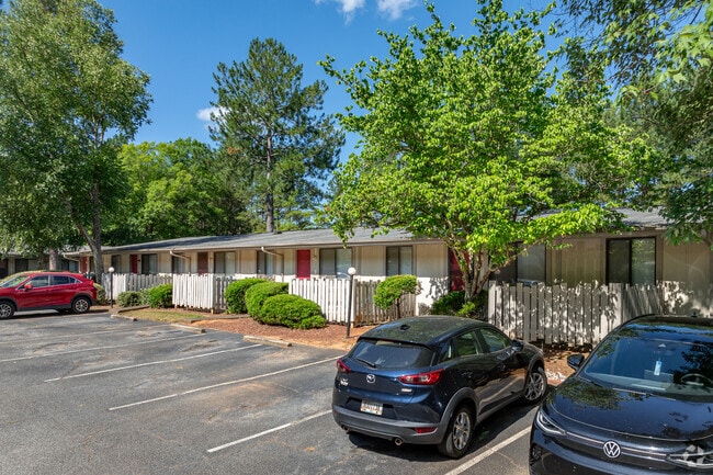
Property Record
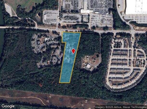
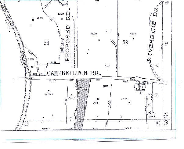
7250 Campbellton Rd Sw, Atlanta, GA 30331
NEARBY LISTINGS FOR SALE OR LEASE
-
-
View all Atlanta listings for sale on LoopNet.com
Property Detail
7250 Campbellton Rd Sw
09C-1500-0054-017-0
Fulton
Apartment
Georgia
AE
54
13121C0328F
11.73 AC
2024
South Fulton
2025
Atlanta
010311
Atlanta-Sandy Springs-Roswell, GA
565,056 SF
DEMOGRAPHICS near 7250 Campbellton Rd Sw
1 Mile
3 Mile
5 Mile
2024 Total Population
2,580
22,960
70,076
2029 Population
2,694
23,912
73,002
Pop Growth 2024-2029
+ 4.42%
+ 4.15%
+ 4.18%
Average Age
35
38
38
2024 Total Households
976
7,879
24,481
HH Growth 2024-2029
+ 4.41%
+ 4.29%
+ 4.24%
Median Household Inc
$106,371
$106,989
$91,307
Avg Household Size
2.70
2.90
2.80
2024 Avg HH Vehicles
2.00
2.00
2.00
Median Home Value
$266,630
$273,397
$269,845
Median Year Built
2010
2005
2002
Nearby Places
Map Layers
Map Styles
 Street
 Aerial
- Restaurants
- Banks
- Shops
- Fitness
- Groceries
PUBLIC TRANSPORTATION
AIRPORT
Hartsfield - Jackson Atlanta International
DRIVE
WALK
Distance
Hartsfield - Jackson Atlanta International
29 min
18.8 mi
Freight Ports
Georgia Ports - Savannah
DRIVE
WALK
Distance
Georgia Ports - Savannah
291 min
256.1 mi
SALE & LEASE HISTORY
LISTING DATE
SALE/LEASE

Sep 24, 2016
For Sale
Nearby Properties
Address
Land Use
TOTAL SIZE
Lot Size
Zoning
Address
Land Use
TOTAL SIZE
Lot Size
Zoning
312,984 SF
19.88 AC
Address
Land Use
TOTAL SIZE
Lot Size
Zoning
1,128,400 SF
76.60 AC
AG1
Address
Land Use
TOTAL SIZE
Lot Size
Zoning
1,045,610 SF
110.63 AC
SUBA
Address
Land Use
TOTAL SIZE
Lot Size
Zoning
75,628 SF
290.39 AC
DCD
Address
Land Use
TOTAL SIZE
Lot Size
Zoning
709,289 SF
112.06 AC
DCD
Address
Land Use
TOTAL SIZE
Lot Size
Zoning
359,608 SF
29.73 AC
DCD
Address
Land Use
TOTAL SIZE
Lot Size
Zoning
799,971 SF
68.45 AC
LI-R
Address
Land Use
TOTAL SIZE
Lot Size
Zoning
295,590 SF
10.25 AC
MIX
Address
Land Use
TOTAL SIZE
Lot Size
Zoning
546,600 SF
32.19 AC
M1
Address
Land Use
TOTAL SIZE
Lot Size
Zoning
1,262,965 SF
24.15 AC
AG1
Address
Land Use
TOTAL SIZE
Lot Size
Zoning
498,420 SF
26.70 AC
M1
Address
Land Use
TOTAL SIZE
Lot Size
Zoning
453,106 SF
36.69 AC
DCD
Address
Land Use
TOTAL SIZE
Lot Size
Zoning
274,956 SF
74.20 AC
AG1
Address
Land Use
TOTAL SIZE
Lot Size
Zoning
457,703 SF
72.15 AC
DCD
Address
Land Use
TOTAL SIZE
Lot Size
Zoning
611,500 SF
37.74 AC
M2
Address
Land Use
TOTAL SIZE
Lot Size
Zoning
623,968 SF
35.87 AC
M1
Address
Land Use
TOTAL SIZE
Lot Size
Zoning
459,006 SF
21.49 AC
M1
Address
Land Use
TOTAL SIZE
Lot Size
Zoning
314,792 SF
51.29 AC
DCD
Address
Land Use
TOTAL SIZE
Lot Size
Zoning
500,400 SF
41.39 AC
M2
Address
Land Use
TOTAL SIZE
Lot Size
Zoning
592,677 SF
27.63 AC
MIA
Address
Land Use
TOTAL SIZE
Lot Size
Zoning
310,689 SF
36.51 AC
LI
Address
Land Use
TOTAL SIZE
Lot Size
Zoning
477,317 SF
37 AC
M1
Address
Land Use
TOTAL SIZE
Lot Size
Zoning
545,000 SF
31.57 AC
M1A
Address
Land Use
TOTAL SIZE
Lot Size
Zoning
433,333 SF
18 AC
M2
Address
Land Use
TOTAL SIZE
Lot Size
Zoning
427,698 SF
33.21 AC
M1
Address
Land Use
TOTAL SIZE
Lot Size
Zoning
384,200 SF
55.45 AC
M1
Address
Land Use
TOTAL SIZE
Lot Size
Zoning
33.74 AC
SUBA
Address
Land Use
TOTAL SIZE
Lot Size
Zoning
252,378 SF
19.20 AC
MIAC
Address
Land Use
TOTAL SIZE
Lot Size
Zoning
298,556 SF
13.90 AC
M1
The World's #1 Commercial Real Estate Marketplace
Connect with us
© 2026 CoStar Group
The information above has been obtained from sources believed reliable. While we do not doubt its accuracy we have not verified it and make no guarantee, warranty or representation about it. It is your responsibility to independently confirm its accuracy and completeness. Any projections, opinions, assumptions, or estimates used are for example only and do not represent the current or future performance of the property. The value of this transaction to you depends on tax and other factors which should be evaluated by your tax, financial, and legal advisors. You and your advisors should conduct a careful, independent investigation of the property to determine to your satisfaction the suitability of the property for your needs.