Property Record
7253 Bennett Lawson Rd, Mansfield, TX 76063

Property Detail
7253 Bennett Lawson Rd
03838897
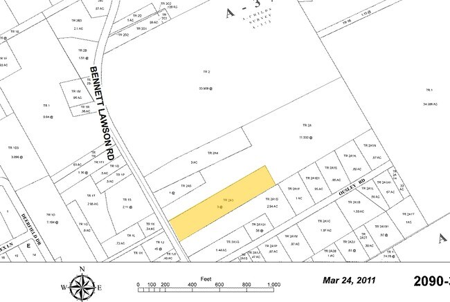
CHILDS, ABRAHAM SURVEY ABSTRACT 373 TRACT 2A03
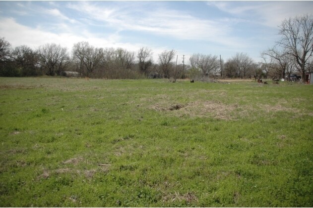
Timberlandforesttreesagricultural
TARRANT
B and X Area of moderate flood hazard, usually the area between the limits of the 100-year and 500-year floods.
Texas
2024
3 AC
2025
Southeast Ft Worth
111307
Dallas/Ft Worth
1,216 SF
Dallas-Fort Worth-Arlington, TX
NEARBY LISTINGS FOR SALE OR LEASE
DEMOGRAPHICS near 7253 Bennett Lawson Rd
1 mile
3 mile
5 mile
2025 Total Population
1,707
22,517
75,204
2030 Population
1,821
24,160
80,712
Pop Growth 2025-2030
+ 6.68%
+ 7.30%
+ 7.32%
Average Age
38
39
39
2025 Total Households
526
7,664
25,707
HH Growth 2025-2030
+ 6.65%
+ 7.45%
+ 7.43%
Median Household Inc
$95,639
$91,871
$100,464
Avg Household Size
3.30
2.90
2.90
2025 Avg HH Vehicles
3.00
2.00
2.00
Median Home Value
$661,091
$412,602
$400,327
Median Year Built
2001
2003
2000
Nearby Places
Map Layers
Map Styles
 Street
 Aerial
Transit
 Traffic
 Biking
Places
Listings with unknown addresses are not visible on the map
- Restaurants
- Banks
- Shops
- Fitness
- Groceries
PUBLIC TRANSPORTATION
AIRPORT
Dallas-Fort Worth International
Drive
Walk
Distance
Dallas-Fort Worth International
46 min
30.7 mi
Dallas Love Field
Drive
Walk
Distance
Dallas Love Field
57 min
39.3 mi
Freight Ports
Port of Shreveport
Drive
Walk
Distance
Port of Shreveport
248 min
225.0 mi
Nearby Properties
Address
Land Use
TOTAL SIZE
Lot Size
Zoning
Address
Land Use
TOTAL SIZE
Lot Size
Zoning
160,000 SF
26.90 AC
Address
Land Use
TOTAL SIZE
Lot Size
Zoning
413,000 SF
19.16 AC
Address
Land Use
TOTAL SIZE
Lot Size
Zoning
298,988 SF
7.16 AC
Address
Land Use
TOTAL SIZE
Lot Size
Zoning
199,066 SF
66.49 AC
Address
Land Use
TOTAL SIZE
Lot Size
Zoning
170,082 SF
36.49 AC
Address
Land Use
TOTAL SIZE
Lot Size
Zoning
724,286 SF
48.41 AC
Address
Land Use
TOTAL SIZE
Lot Size
Zoning
234,580 SF
65.82 AC
Address
Land Use
TOTAL SIZE
Lot Size
Zoning
229,168 SF
6.13 AC
Address
Land Use
TOTAL SIZE
Lot Size
Zoning
149,494 SF
3.73 AC
Address
Land Use
TOTAL SIZE
Lot Size
Zoning
79,070 SF
11.98 AC
Address
Land Use
TOTAL SIZE
Lot Size
Zoning
22.84 AC
Address
Land Use
TOTAL SIZE
Lot Size
Zoning
41,960 SF
13.70 AC
Address
Land Use
TOTAL SIZE
Lot Size
Zoning
73,323 SF
11.87 AC
Address
Land Use
TOTAL SIZE
Lot Size
Zoning
1,008 SF
20.48 AC
Address
Land Use
TOTAL SIZE
Lot Size
Zoning
38,400 SF
43.84 AC
Address
Land Use
TOTAL SIZE
Lot Size
Zoning
2,088 SF
19.19 AC
Address
Land Use
TOTAL SIZE
Lot Size
Zoning
207,000 SF
5.67 AC
Address
Land Use
TOTAL SIZE
Lot Size
Zoning
50,000 SF
17.96 AC
Address
Land Use
TOTAL SIZE
Lot Size
Zoning
83,484 SF
5 AC
Address
Land Use
TOTAL SIZE
Lot Size
Zoning
107,055 SF
9.92 AC
Address
Land Use
TOTAL SIZE
Lot Size
Zoning
191,419 SF
19.10 AC
Address
Land Use
TOTAL SIZE
Lot Size
Zoning
78,306 SF
5.13 AC
Address
Land Use
TOTAL SIZE
Lot Size
Zoning
37,133 SF
19.10 AC
Address
Land Use
TOTAL SIZE
Lot Size
Zoning
77,845 SF
13.52 AC
Address
Land Use
TOTAL SIZE
Lot Size
Zoning
82 SF
13.63 AC
Address
Land Use
TOTAL SIZE
Lot Size
Zoning
77,411 SF
6.82 AC
Address
Land Use
TOTAL SIZE
Lot Size
Zoning
80,424 SF
4.20 AC
Address
Land Use
TOTAL SIZE
Lot Size
Zoning
35,440 SF
16 AC
Address
Land Use
TOTAL SIZE
Lot Size
Zoning
78,000 SF
9.06 AC
Address
Land Use
TOTAL SIZE
Lot Size
Zoning
37,500 SF
1 AC
The World's #1 Commercial Real Estate Marketplace
Connect with us
© 2026 CoStar Group
The information above has been obtained from sources believed reliable. While we do not doubt its accuracy we have not verified it and make no guarantee, warranty or representation about it. It is your responsibility to independently confirm its accuracy and completeness. Any projections, opinions, assumptions, or estimates used are for example only and do not represent the current or future performance of the property. The value of this transaction to you depends on tax and other factors which should be evaluated by your tax, financial, and legal advisors. You and your advisors should conduct a careful, independent investigation of the property to determine to your satisfaction the suitability of the property for your needs.