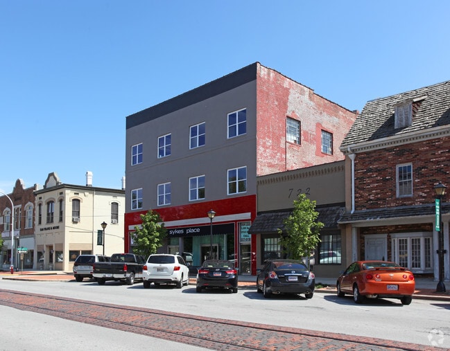
Property Record
726 Bank St Ne, Decatur, AL 35601

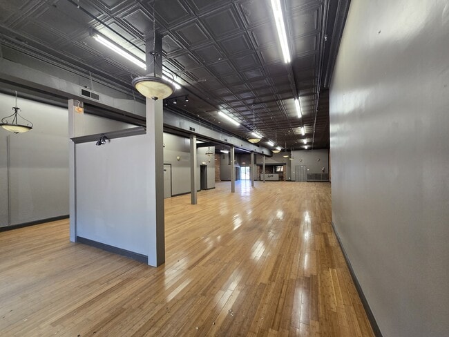
Current Lease Availabilities
NEARBY LISTINGS FOR SALE OR LEASE
Property Detail
726 Bank St Ne
Decatur, AL
Decatur Mineral And Land Companys Subdiv
03-04-18-1-032-007.000
PT LT 307 CITY OF DECATUR BEG AT INT SE ROW BANK ST & SW ROW LAFAYETTE ST TH SE 148' ON SW ROW LAFAYETTE ST TH SW 53.4' TH NW
Storebuilding
Morgan
X
Alabama
01083C0326F
307
2025
0.18 AC
2024
Downtown Decatur
000400
Other Market Areas
3,900 SF
DEMOGRAPHICS near 726 Bank St Ne
1 Mile
3 Mile
5 Mile
2024 Total Population
5,137
29,111
54,153
2029 Population
5,277
29,464
54,472
Pop Growth 2024-2029
+ 2.73%
+ 1.21%
+ 0.59%
Average Age
43
39
40
2024 Total Households
2,050
11,290
22,071
HH Growth 2024-2029
+ 2.88%
+ 1.27%
+ 0.59%
Median Household Inc
$38,269
$42,238
$47,984
Avg Household Size
2.00
2.40
2.30
2024 Avg HH Vehicles
2.00
2.00
2.00
Median Home Value
$115,349
$118,125
$149,621
Median Year Built
1957
1966
1976
Nearby Places
Map Layers
Map Styles
 Street
 Aerial
- Restaurants
- Banks
- Shops
- Fitness
- Groceries
PUBLIC TRANSPORTATION
AIRPORT
Huntsville International-Carl T Jones Field
DRIVE
WALK
Distance
Huntsville International-Carl T Jones Field
24 min
15.9 mi
Nearby Properties
Address
Land Use
TOTAL SIZE
Lot Size
Zoning
Address
Land Use
TOTAL SIZE
Lot Size
Zoning
176,476 SF
Address
Land Use
TOTAL SIZE
Lot Size
Zoning
121,551 SF
Address
Land Use
TOTAL SIZE
Lot Size
Zoning
90,249 SF
8 AC
Address
Land Use
TOTAL SIZE
Lot Size
Zoning
7,812 SF
162 AC
Address
Land Use
TOTAL SIZE
Lot Size
Zoning
258,250 SF
55 AC
Address
Land Use
TOTAL SIZE
Lot Size
Zoning
15,331 SF
87 AC
Address
Land Use
TOTAL SIZE
Lot Size
Zoning
133,056 SF
6.29 AC
Address
Land Use
TOTAL SIZE
Lot Size
Zoning
132,156 SF
1.69 AC
Address
Land Use
TOTAL SIZE
Lot Size
Zoning
77,430 SF
19 AC
Address
Land Use
TOTAL SIZE
Lot Size
Zoning
40,212 SF
1.21 AC
Address
Land Use
TOTAL SIZE
Lot Size
Zoning
54,544 SF
6.53 AC
Address
Land Use
TOTAL SIZE
Lot Size
Zoning
106,165 SF
0.80 AC
Address
Land Use
TOTAL SIZE
Lot Size
Zoning
100,632 SF
20 AC
Address
Land Use
TOTAL SIZE
Lot Size
Zoning
2,010 SF
20 AC
Address
Land Use
TOTAL SIZE
Lot Size
Zoning
220,128 SF
34 AC
Address
Land Use
TOTAL SIZE
Lot Size
Zoning
145,413 SF
2.30 AC
Address
Land Use
TOTAL SIZE
Lot Size
Zoning
2,546 SF
9.30 AC
Address
Land Use
TOTAL SIZE
Lot Size
Zoning
64,449 SF
12 AC
Address
Land Use
TOTAL SIZE
Lot Size
Zoning
4,865 SF
22 AC
Address
Land Use
TOTAL SIZE
Lot Size
Zoning
32,821 SF
1.68 AC
Address
Land Use
TOTAL SIZE
Lot Size
Zoning
49,384 SF
1.07 AC
Address
Land Use
TOTAL SIZE
Lot Size
Zoning
6.50 AC
Address
Land Use
TOTAL SIZE
Lot Size
Zoning
19,494 SF
3.30 AC
Address
Land Use
TOTAL SIZE
Lot Size
Zoning
146,160 SF
41.50 AC
Address
Land Use
TOTAL SIZE
Lot Size
Zoning
42,197 SF
3.75 AC
Address
Land Use
TOTAL SIZE
Lot Size
Zoning
53,680 SF
0.50 AC
Address
Land Use
TOTAL SIZE
Lot Size
Zoning
30,076 SF
4.46 AC
Address
Land Use
TOTAL SIZE
Lot Size
Zoning
10,632 SF
0.25 AC
Address
Land Use
TOTAL SIZE
Lot Size
Zoning
104,793 SF
2 AC
The World's #1 Commercial Real Estate Marketplace
Connect with us
© 2026 CoStar Group
The information above has been obtained from sources believed reliable. While we do not doubt its accuracy we have not verified it and make no guarantee, warranty or representation about it. It is your responsibility to independently confirm its accuracy and completeness. Any projections, opinions, assumptions, or estimates used are for example only and do not represent the current or future performance of the property. The value of this transaction to you depends on tax and other factors which should be evaluated by your tax, financial, and legal advisors. You and your advisors should conduct a careful, independent investigation of the property to determine to your satisfaction the suitability of the property for your needs.