Property Record
7262 Lansing Rd, Dimondale, MI 48821
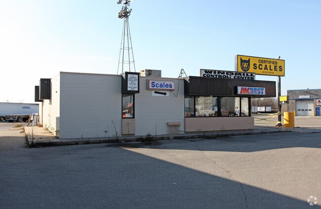

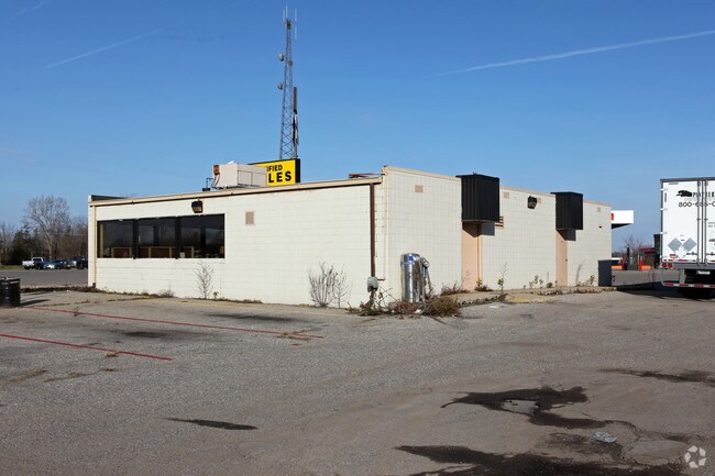
Property Detail
7262 Lansing Rd
080-003-300-060-00
COM.SLY LINE LANSING RD 203.6 FT N & 786.7 FT N44DEG 01MIN 55SEC E OF SW COR. SEC. 3, N44DEG 01MIN 55SEC E 709.67 FT, S 46DEG 13MIN 45SEC E 178.87 FT ON SLY LINE PATS DR & SELY 130.6 FT, CURVE TO LEFT.(CHORD S69DEG 10MIN 55SEC E 126.25 FT) TO N&S 1/8
Officebuilding
Eaton
B-2
Michigan
B and X Area of moderate flood hazard, usually the area between the limits of the 100-year and 500-year floods.
12.32 AC
2024
Outlying Eaton County
2025
West Michigan
021401
Lansing-East Lansing, MI
39,698 SF
NEARBY LISTINGS FOR SALE OR LEASE
DEMOGRAPHICS near 7262 Lansing Rd
1 mile
3 mile
5 mile
2025 Total Population
2,020
10,838
59,918
2030 Population
2,045
10,916
60,119
Pop Growth 2025-2030
+ 1.24%
+ 0.72%
+ 0.34%
Average Age
46
42
41
2025 Total Households
893
4,470
25,111
HH Growth 2025-2030
+ 1.23%
+ 0.56%
+ 0.34%
Median Household Inc
$79,849
$67,366
$65,495
Avg Household Size
2.30
2.40
2.30
2025 Avg HH Vehicles
2.00
2.00
2.00
Median Home Value
$242,774
$219,008
$195,003
Median Year Built
1982
1976
1973
Nearby Places
Map Layers
Map Styles
 Street
 Aerial
Transit
 Traffic
 Biking
Places
Listings with unknown addresses are not visible on the map
- Restaurants
- Banks
- Shops
- Fitness
- Groceries
PUBLIC TRANSPORTATION
AIRPORT
Capital Region International
Drive
Walk
Distance
Capital Region International
16 min
9.2 mi
Freight Ports
Port of Toledo
Drive
Walk
Distance
Port of Toledo
148 min
127.3 mi
Nearby Properties
Address
Land Use
TOTAL SIZE
Lot Size
Zoning
Address
Land Use
TOTAL SIZE
Lot Size
Zoning
Address
Land Use
TOTAL SIZE
Lot Size
Zoning
4,395,257 SF
324 AC
I HVY
Address
Land Use
TOTAL SIZE
Lot Size
Zoning
1,085,633 SF
115.14 AC
NONE
Address
Land Use
TOTAL SIZE
Lot Size
Zoning
628,230 SF
38.20 AC
NONE
Address
Land Use
TOTAL SIZE
Lot Size
Zoning
286.23 AC
NONE
Address
Land Use
TOTAL SIZE
Lot Size
Zoning
1,059,295 SF
139.28 AC
NONE
Address
Land Use
TOTAL SIZE
Lot Size
Zoning
198,225 SF
11.54 AC
NONE
Address
Land Use
TOTAL SIZE
Lot Size
Zoning
628,651 SF
34.29 AC
NONE
Address
Land Use
TOTAL SIZE
Lot Size
Zoning
231,000 SF
26 AC
Address
Land Use
TOTAL SIZE
Lot Size
Zoning
292,918 SF
I-FAC
Address
Land Use
TOTAL SIZE
Lot Size
Zoning
824,570 SF
47.65 AC
NONE
Address
Land Use
TOTAL SIZE
Lot Size
Zoning
144,630 SF
11.51 AC
M-1
Address
Land Use
TOTAL SIZE
Lot Size
Zoning
219,176 SF
9.45 AC
NONE
Address
Land Use
TOTAL SIZE
Lot Size
Zoning
590.26 AC
I HVY
Address
Land Use
TOTAL SIZE
Lot Size
Zoning
50,364 SF
25.57 AC
M-1
Address
Land Use
TOTAL SIZE
Lot Size
Zoning
250,100 SF
25.45 AC
NONE
Address
Land Use
TOTAL SIZE
Lot Size
Zoning
404,215 SF
40 AC
NONE
Address
Land Use
TOTAL SIZE
Lot Size
Zoning
160,000 SF
16.18 AC
Address
Land Use
TOTAL SIZE
Lot Size
Zoning
269,800 SF
20.10 AC
NONE
Address
Land Use
TOTAL SIZE
Lot Size
Zoning
53,147 SF
15.70 AC
C
Address
Land Use
TOTAL SIZE
Lot Size
Zoning
133,280 SF
27.22 AC
Address
Land Use
TOTAL SIZE
Lot Size
Zoning
147,234 SF
17.13 AC
NONE
Address
Land Use
TOTAL SIZE
Lot Size
Zoning
166,296 SF
39.72 AC
NONE
Address
Land Use
TOTAL SIZE
Lot Size
Zoning
441,242 SF
41.27 AC
NONE
Address
Land Use
TOTAL SIZE
Lot Size
Zoning
516,239 SF
33.56 AC
NONE
Address
Land Use
TOTAL SIZE
Lot Size
Zoning
111,136 SF
I-FAC
Address
Land Use
TOTAL SIZE
Lot Size
Zoning
7,689 SF
148.47 AC
DM-1 RE
Address
Land Use
TOTAL SIZE
Lot Size
Zoning
143.80 AC
Address
Land Use
TOTAL SIZE
Lot Size
Zoning
3,006 SF
136 AC
DM-1 RE
Address
Land Use
TOTAL SIZE
Lot Size
Zoning
53,147 SF
17.01 AC
NONE
The World's #1 Commercial Real Estate Marketplace
Connect with us
© 2026 CoStar Group
The information above has been obtained from sources believed reliable. While we do not doubt its accuracy we have not verified it and make no guarantee, warranty or representation about it. It is your responsibility to independently confirm its accuracy and completeness. Any projections, opinions, assumptions, or estimates used are for example only and do not represent the current or future performance of the property. The value of this transaction to you depends on tax and other factors which should be evaluated by your tax, financial, and legal advisors. You and your advisors should conduct a careful, independent investigation of the property to determine to your satisfaction the suitability of the property for your needs.