Property Record
7266 8Th Ave S, Seattle, WA 98108
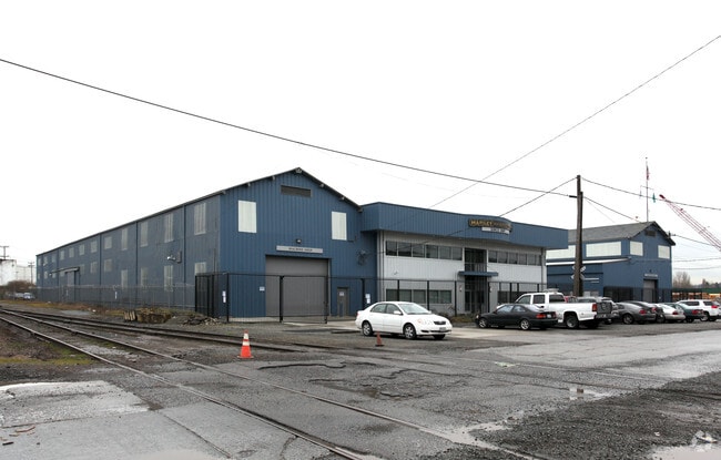


Property Detail
7266 8Th Ave S
213620-0210
DUWAMISH INDUSTRIAL ADD
Lightindustrial
King
MML U/85
Washington
B and X Area of moderate flood hazard, usually the area between the limits of the 100-year and 500-year floods.
8-21
2025
1.31 AC
2024
Georgetown/Duwamish S
010900
Seattle/Puget Sound
12,000 SF
Seattle-Tacoma-Bellevue, WA
NEARBY LISTINGS FOR SALE OR LEASE
DEMOGRAPHICS near 7266 8Th Ave S
1 mile
3 mile
5 mile
2025 Total Population
5,207
152,961
351,607
2030 Population
5,449
159,649
368,138
Pop Growth 2025-2030
+ 4.65%
+ 4.37%
+ 4.70%
Average Age
39
39
40
2025 Total Households
2,067
58,073
143,510
HH Growth 2025-2030
+ 4.64%
+ 4.43%
+ 4.94%
Median Household Inc
$88,421
$106,923
$107,397
Avg Household Size
2.40
2.50
2.30
2025 Avg HH Vehicles
2.00
2.00
2.00
Median Home Value
$736,825
$759,965
$803,299
Median Year Built
1957
1969
1970
Nearby Places
Map Layers
Map Styles
 Street
 Aerial
Layers
 Traffic
 Biking
Places
Listings with unknown addresses are not visible on the map
- Restaurants
- Banks
- Shops
- Fitness
- Groceries
PUBLIC TRANSPORTATION
COMMUTER RAIL
King Street (Seattle) Station (Sounder South Line - Central Puget Sound Regional Transit Authority Rail (Link Light Rail/Sounder))
Drive
Walk
Distance
King Street (Seattle) Station (Sounder South Line - Central Puget Sound Regional Transit Authority Rail (Link Light Rail/Sounder))
10 min
5.1 mi
AIRPORT
Seattle-Tacoma International
Drive
Walk
Distance
Seattle-Tacoma International
18 min
9.7 mi
Seattle Paine Field International
Drive
Walk
Distance
Seattle Paine Field International
42 min
29.0 mi
Freight Ports
Port of Seattle
Drive
Walk
Distance
Port of Seattle
10 min
3.8 mi
SALE & LEASE HISTORY
LISTING DATE
SALE/LEASE

Nov 19, 2024
For Sale
May 26, 2022
For Sale
Nearby Properties
Address
Land Use
TOTAL SIZE
Lot Size
Zoning
Address
Land Use
TOTAL SIZE
Lot Size
Zoning
30,290 SF
564.80 AC
MML U/85
Address
Land Use
TOTAL SIZE
Lot Size
Zoning
56,474 SF
99.48 AC
MML U/85
Address
Land Use
TOTAL SIZE
Lot Size
Zoning
1,134 SF
53.17 AC
MIC/H
Address
Land Use
TOTAL SIZE
Lot Size
Zoning
533,910 SF
15.04 AC
MML U/85
Address
Land Use
TOTAL SIZE
Lot Size
Zoning
162,157 SF
24.06 AC
MML U/85
Address
Land Use
TOTAL SIZE
Lot Size
Zoning
147,878 SF
13.67 AC
MML U/85
Address
Land Use
TOTAL SIZE
Lot Size
Zoning
441,071 SF
59.59 AC
MIO-50-LR1
Address
Land Use
TOTAL SIZE
Lot Size
Zoning
218,805 SF
51.21 AC
MIO-105-LR
Address
Land Use
TOTAL SIZE
Lot Size
Zoning
141,643 SF
11.44 AC
MIC/H
Address
Land Use
TOTAL SIZE
Lot Size
Zoning
525,975 SF
37.45 AC
MML U/85
Address
Land Use
TOTAL SIZE
Lot Size
Zoning
2,456 SF
43.60 AC
MML U/85
Address
Land Use
TOTAL SIZE
Lot Size
Zoning
424,367 SF
32.99 AC
MML U/85
Address
Land Use
TOTAL SIZE
Lot Size
Zoning
230,950 SF
6.56 AC
CBP
Address
Land Use
TOTAL SIZE
Lot Size
Zoning
217,580 SF
8.72 AC
LR3 (M)
Address
Land Use
TOTAL SIZE
Lot Size
Zoning
64 SF
36.70 AC
MML U/85
Address
Land Use
TOTAL SIZE
Lot Size
Zoning
164,256 SF
8.47 AC
LR2 (M)
Address
Land Use
TOTAL SIZE
Lot Size
Zoning
326,751 SF
10.92 AC
MML U/85
Address
Land Use
TOTAL SIZE
Lot Size
Zoning
18,888 SF
85.89 AC
NR2
Address
Land Use
TOTAL SIZE
Lot Size
Zoning
179,161 SF
19.03 AC
MML U/85
Address
Land Use
TOTAL SIZE
Lot Size
Zoning
411,584 SF
18.37 AC
MML U/85
Address
Land Use
TOTAL SIZE
Lot Size
Zoning
34.25 AC
MIC/H
Address
Land Use
TOTAL SIZE
Lot Size
Zoning
323,916 SF
10.33 AC
MML U/85
Address
Land Use
TOTAL SIZE
Lot Size
Zoning
169,110 SF
29.99 AC
MIC/H
Address
Land Use
TOTAL SIZE
Lot Size
Zoning
8,110 SF
131.10 AC
NR3
Address
Land Use
TOTAL SIZE
Lot Size
Zoning
63,387 SF
19.90 AC
NC3-75 (M1
Address
Land Use
TOTAL SIZE
Lot Size
Zoning
241,186 SF
25.51 AC
MIC/H
Address
Land Use
TOTAL SIZE
Lot Size
Zoning
166,212 SF
1.57 AC
NC2P-55 (M
Address
Land Use
TOTAL SIZE
Lot Size
Zoning
31,737 SF
9.55 AC
RSL (M)
Address
Land Use
TOTAL SIZE
Lot Size
Zoning
156,585 SF
1.21 AC
C1-75 (M)
Address
Land Use
TOTAL SIZE
Lot Size
Zoning
59.81 AC
MML U/85
The World's #1 Commercial Real Estate Marketplace
Connect with us
© 2026 CoStar Group
The information above has been obtained from sources believed reliable. While we do not doubt its accuracy we have not verified it and make no guarantee, warranty or representation about it. It is your responsibility to independently confirm its accuracy and completeness. Any projections, opinions, assumptions, or estimates used are for example only and do not represent the current or future performance of the property. The value of this transaction to you depends on tax and other factors which should be evaluated by your tax, financial, and legal advisors. You and your advisors should conduct a careful, independent investigation of the property to determine to your satisfaction the suitability of the property for your needs.