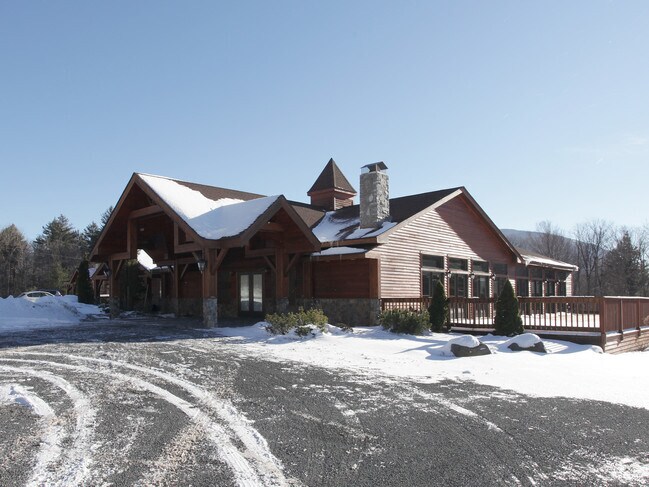
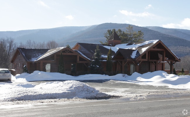
Property Record
7267 Route 23A, Hunter, NY 12442

Property Detail
7267 Route 23A
Restaurantbuilding
GREENE
01 - NOT Z
New York
B and X Area of moderate flood hazard, usually the area between the limits of the 100-year and 500-year floods.
23.100
2025
1.30 AC
2025
Greene County
080402
Albany/Schenectady/Troy
4,260 SF
193689-164-000-0003-023-100-0000
NEARBY LISTINGS FOR SALE OR LEASE
DEMOGRAPHICS near 7267 Route 23A
1 mile
3 mile
5 mile
2025 Total Population
22
777
2,127
2030 Population
19
684
1,966
Pop Growth 2025-2030
(13.64%)
(11.97%)
(7.57%)
Average Age
48
43
45
2025 Total Households
10
305
872
HH Growth 2025-2030
(10.00%)
(12.79%)
(7.34%)
Median Household Inc
$99,999
$73,827
$67,500
Avg Household Size
1.80
2.10
2.10
2025 Avg HH Vehicles
2.00
2.00
2.00
Median Home Value
$299,999
$326,470
$337,500
Median Year Built
1982
1980
1980
Nearby Places
Map Layers
Map Styles
 Street
 Aerial
Layers
 Traffic
 Biking
Places
Listings with unknown addresses are not visible on the map
- Restaurants
- Banks
- Shops
- Fitness
- Groceries
Nearby Properties
Address
Land Use
TOTAL SIZE
Lot Size
Zoning
Address
Land Use
TOTAL SIZE
Lot Size
Zoning
0.01 AC
01 - NOT Z
Address
Land Use
TOTAL SIZE
Lot Size
Zoning
100,291 SF
0.01 AC
01 - NOT Z
Address
Land Use
TOTAL SIZE
Lot Size
Zoning
35,881 SF
1.10 AC
01 - NOT Z
Address
Land Use
TOTAL SIZE
Lot Size
Zoning
61,470 SF
6.60 AC
01 - NOT Z
Address
Land Use
TOTAL SIZE
Lot Size
Zoning
2,345 SF
2.10 AC
01 - NOT Z
Address
Land Use
TOTAL SIZE
Lot Size
Zoning
11,559 SF
53.52 AC
01 - NOT Z
Address
Land Use
TOTAL SIZE
Lot Size
Zoning
194.02 AC
RC
Address
Land Use
TOTAL SIZE
Lot Size
Zoning
5,664 SF
73.60 AC
01 - NOT Z
Address
Land Use
TOTAL SIZE
Lot Size
Zoning
46,188 SF
5.30 AC
01 - NOT Z
Address
Land Use
TOTAL SIZE
Lot Size
Zoning
43,162 SF
3.50 AC
01 - NOT Z
Address
Land Use
TOTAL SIZE
Lot Size
Zoning
23,600 SF
2.80 AC
01 - NOT Z
Address
Land Use
TOTAL SIZE
Lot Size
Zoning
25,896 SF
6.20 AC
01 - NOT Z
Address
Land Use
TOTAL SIZE
Lot Size
Zoning
6,860 SF
107.90 AC
01 - NOT Z
Address
Land Use
TOTAL SIZE
Lot Size
Zoning
67.48 AC
RC
Address
Land Use
TOTAL SIZE
Lot Size
Zoning
0.01 AC
01 - NOT Z
Address
Land Use
TOTAL SIZE
Lot Size
Zoning
438.71 AC
C
Address
Land Use
TOTAL SIZE
Lot Size
Zoning
7,086 SF
8.70 AC
01 - NOT Z
Address
Land Use
TOTAL SIZE
Lot Size
Zoning
26,992 SF
1.70 AC
01 - NOT Z
Address
Land Use
TOTAL SIZE
Lot Size
Zoning
557.50 AC
01 - NOT Z
Address
Land Use
TOTAL SIZE
Lot Size
Zoning
15,360 SF
0.64 AC
01 - NOT Z
Address
Land Use
TOTAL SIZE
Lot Size
Zoning
900 SF
135 AC
01 - NOT Z
Address
Land Use
TOTAL SIZE
Lot Size
Zoning
611.70 AC
01 - NOT Z
Address
Land Use
TOTAL SIZE
Lot Size
Zoning
582.90 AC
01 - NOT Z
Address
Land Use
TOTAL SIZE
Lot Size
Zoning
Address
Land Use
TOTAL SIZE
Lot Size
Zoning
5,946 SF
3.40 AC
01 - NOT Z
Address
Land Use
TOTAL SIZE
Lot Size
Zoning
10,138 SF
1.50 AC
01 - NOT Z
Address
Land Use
TOTAL SIZE
Lot Size
Zoning
19,916 SF
0.01 AC
01 - NOT Z
Address
Land Use
TOTAL SIZE
Lot Size
Zoning
4,511 SF
38.90 AC
01 - NOT Z
Address
Land Use
TOTAL SIZE
Lot Size
Zoning
13,068 SF
1.40 AC
01 - NOT Z
Address
Land Use
TOTAL SIZE
Lot Size
Zoning
2,688 SF
1.52 AC
01 - NOT Z
The World's #1 Commercial Real Estate Marketplace
Connect with us
© 2026 CoStar Group
The information above has been obtained from sources believed reliable. While we do not doubt its accuracy we have not verified it and make no guarantee, warranty or representation about it. It is your responsibility to independently confirm its accuracy and completeness. Any projections, opinions, assumptions, or estimates used are for example only and do not represent the current or future performance of the property. The value of this transaction to you depends on tax and other factors which should be evaluated by your tax, financial, and legal advisors. You and your advisors should conduct a careful, independent investigation of the property to determine to your satisfaction the suitability of the property for your needs.