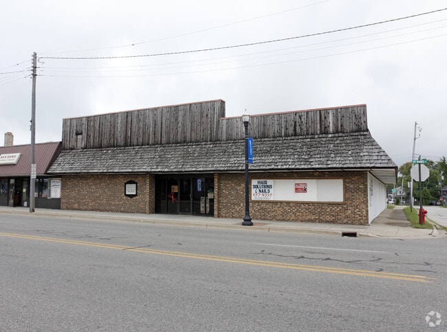
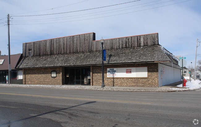
Property Record
727 E Mount Morris St, Mount Morris, MI 48458

Property Detail
727 E Mount Morris St
57-06-551-010
PART OF LOTS 9 & 10 BEG AT INTERSECTION OF N LINE OF GENESEE ST & W LINE OF UNION ST TH N 89 DEG 44 MIN 10 SEC W 67.97 FT TH
Commercialnec
GENESEE
R-1 SF PUD
Michigan
B and X Area of moderate flood hazard, usually the area between the limits of the 100-year and 500-year floods.
9-10
2024
0.15 AC
2025
Flint
012310
Detroit
7,790 SF
Flint, MI
NEARBY LISTINGS FOR SALE OR LEASE
DEMOGRAPHICS near 727 E Mount Morris St
1 mile
3 mile
5 mile
2025 Total Population
5,339
22,654
65,131
2030 Population
5,269
22,937
66,005
Pop Growth 2025-2030
(1.31%)
+ 1.25%
+ 1.34%
Average Age
38
40
40
2025 Total Households
2,220
9,218
26,753
HH Growth 2025-2030
(1.22%)
+ 1.25%
+ 1.36%
Median Household Inc
$48,015
$42,700
$42,099
Avg Household Size
2.40
2.40
2.40
2025 Avg HH Vehicles
2.00
2.00
1.00
Median Home Value
$100,691
$86,148
$95,562
Median Year Built
1955
1964
1964
Nearby Places
Map Layers
Map Styles
 Street
 Aerial
Transit
 Traffic
 Biking
Places
Listings with unknown addresses are not visible on the map
- Restaurants
- Banks
- Shops
- Fitness
- Groceries
PUBLIC TRANSPORTATION
COMMUTER RAIL
Drive
Walk
Distance
15 min
8.5 mi
AIRPORT
Bishop International
Drive
Walk
Distance
Bishop International
29 min
16.4 mi
MBS International
Drive
Walk
Distance
MBS International
61 min
44.2 mi
SALE & LEASE HISTORY
LISTING DATE
SALE/LEASE

Aug 07, 2025
For Sale
Apr 10, 2018
For Lease
Nearby Properties
Address
Land Use
TOTAL SIZE
Lot Size
Zoning
Address
Land Use
TOTAL SIZE
Lot Size
Zoning
2,629 SF
119.59 AC
R-4 MANUF
Address
Land Use
TOTAL SIZE
Lot Size
Zoning
46,808 SF
32.06 AC
I-2 HVY IN
Address
Land Use
TOTAL SIZE
Lot Size
Zoning
114,888 SF
11.86 AC
I-2 HVY IN
Address
Land Use
TOTAL SIZE
Lot Size
Zoning
94,719 SF
7.55 AC
R-1 SF PUD
Address
Land Use
TOTAL SIZE
Lot Size
Zoning
Address
Land Use
TOTAL SIZE
Lot Size
Zoning
97,998 SF
11.30 AC
R-1 SF PUD
Address
Land Use
TOTAL SIZE
Lot Size
Zoning
7.33 AC
Address
Land Use
TOTAL SIZE
Lot Size
Zoning
77,994 SF
5.68 AC
RU-2
Address
Land Use
TOTAL SIZE
Lot Size
Zoning
9,934 SF
9.70 AC
I-2 HVY IN
Address
Land Use
TOTAL SIZE
Lot Size
Zoning
76,051 SF
8.31 AC
C-2 HWY CO
Address
Land Use
TOTAL SIZE
Lot Size
Zoning
Address
Land Use
TOTAL SIZE
Lot Size
Zoning
9,238 SF
84.53 AC
MHP
Address
Land Use
TOTAL SIZE
Lot Size
Zoning
3,434 SF
5.63 AC
I-1 LHGT I
Address
Land Use
TOTAL SIZE
Lot Size
Zoning
Address
Land Use
TOTAL SIZE
Lot Size
Zoning
10.15 AC
Address
Land Use
TOTAL SIZE
Lot Size
Zoning
20.06 AC
Address
Land Use
TOTAL SIZE
Lot Size
Zoning
54,648 SF
4.68 AC
RU-2
Address
Land Use
TOTAL SIZE
Lot Size
Zoning
1.70 AC
Address
Land Use
TOTAL SIZE
Lot Size
Zoning
2.31 AC
Address
Land Use
TOTAL SIZE
Lot Size
Zoning
49,900 SF
10.17 AC
C-2
Address
Land Use
TOTAL SIZE
Lot Size
Zoning
1,912 SF
64.42 AC
MHP
Address
Land Use
TOTAL SIZE
Lot Size
Zoning
25,800 SF
4.94 AC
I-2 HVY IN
Address
Land Use
TOTAL SIZE
Lot Size
Zoning
1,430 SF
71.54 AC
R-4 MANUF
Address
Land Use
TOTAL SIZE
Lot Size
Zoning
1,732 SF
0.87 AC
R-1 SF PUD
Address
Land Use
TOTAL SIZE
Lot Size
Zoning
33,200 SF
3.24 AC
I-1 LHGT I
Address
Land Use
TOTAL SIZE
Lot Size
Zoning
Address
Land Use
TOTAL SIZE
Lot Size
Zoning
339 SF
26.24 AC
R-4 MANUF
Address
Land Use
TOTAL SIZE
Lot Size
Zoning
Address
Land Use
TOTAL SIZE
Lot Size
Zoning
9,105 SF
2.29 AC
C-2 HWY CO
Address
Land Use
TOTAL SIZE
Lot Size
Zoning
16,676 SF
31.01 AC
C-2 HWY CO
The World's #1 Commercial Real Estate Marketplace
Connect with us
© 2026 CoStar Group
The information above has been obtained from sources believed reliable. While we do not doubt its accuracy we have not verified it and make no guarantee, warranty or representation about it. It is your responsibility to independently confirm its accuracy and completeness. Any projections, opinions, assumptions, or estimates used are for example only and do not represent the current or future performance of the property. The value of this transaction to you depends on tax and other factors which should be evaluated by your tax, financial, and legal advisors. You and your advisors should conduct a careful, independent investigation of the property to determine to your satisfaction the suitability of the property for your needs.