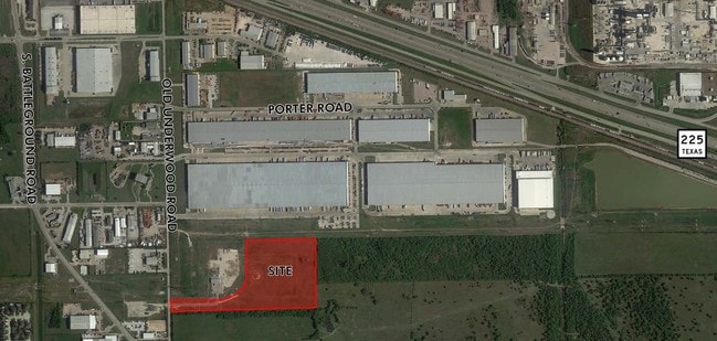
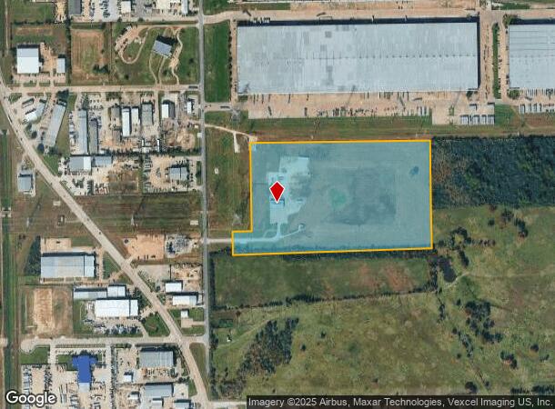
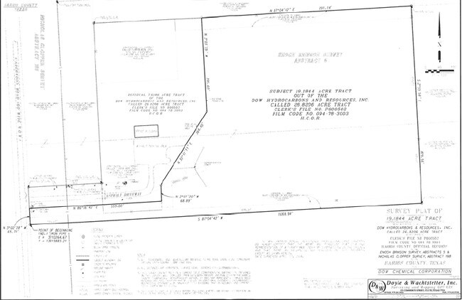
Property Record
727 Old Underwood Rd, La Porte, TX 77571
NEARBY LISTINGS FOR SALE OR LEASE
-
-
-
-
No Photo
-
-
-
-
View all La Porte listings for sale on LoopNet.com
Property Detail
727 Old Underwood Rd
0642220000055
Staashen
Chemical
PT TRS 1A 2B & 6B (NON AG-USE) ABST 5 E BRINSON STAASHEN
X
Harris
48201C0930M
Texas
2024
8.25 AC
2025
Gulf Freeway/Pasadena
343301
Houston
5,000 SF
Houston-The Woodlands-Sugar Land, TX
DEMOGRAPHICS near 727 Old Underwood Rd
1 Mile
3 Mile
5 Mile
2024 Total Population
2,899
49,496
96,191
2029 Population
2,926
50,272
98,015
Pop Growth 2024-2029
+ 0.93%
+ 1.57%
+ 1.90%
Average Age
37
39
38
2024 Total Households
923
17,367
33,502
HH Growth 2024-2029
+ 0.98%
+ 1.53%
+ 1.84%
Median Household Inc
$116,749
$86,806
$77,294
Avg Household Size
3.10
2.80
2.80
2024 Avg HH Vehicles
2.00
2.00
2.00
Median Home Value
$277,137
$218,620
$203,043
Median Year Built
2000
1983
1983
Nearby Places
Map Layers
Map Styles
 Street
 Aerial
- Restaurants
- Banks
- Shops
- Fitness
- Groceries
PUBLIC TRANSPORTATION
AIRPORT
William P Hobby
DRIVE
WALK
Distance
William P Hobby
33 min
19.5 mi
George Bush Intcntl/Houston
DRIVE
WALK
Distance
George Bush Intcntl/Houston
43 min
32.3 mi
Freight Ports
Port of Houston
DRIVE
WALK
Distance
Port of Houston
25 min
15.2 mi
SALE & LEASE HISTORY
LISTING DATE
SALE/LEASE

Sep 24, 2016
For Sale
Sep 24, 2016
For Sale
Nearby Properties
Address
Land Use
TOTAL SIZE
Lot Size
Zoning
Address
Land Use
TOTAL SIZE
Lot Size
Zoning
55.98 AC
Address
Land Use
TOTAL SIZE
Lot Size
Zoning
Address
Land Use
TOTAL SIZE
Lot Size
Zoning
Address
Land Use
TOTAL SIZE
Lot Size
Zoning
263.71 AC
Address
Land Use
TOTAL SIZE
Lot Size
Zoning
4,960,504 SF
141.62 AC
Address
Land Use
TOTAL SIZE
Lot Size
Zoning
36.31 AC
Address
Land Use
TOTAL SIZE
Lot Size
Zoning
67.91 AC
Address
Land Use
TOTAL SIZE
Lot Size
Zoning
64.83 AC
Address
Land Use
TOTAL SIZE
Lot Size
Zoning
13.76 AC
Address
Land Use
TOTAL SIZE
Lot Size
Zoning
Address
Land Use
TOTAL SIZE
Lot Size
Zoning
900,000 SF
42.88 AC
Address
Land Use
TOTAL SIZE
Lot Size
Zoning
120.26 AC
Address
Land Use
TOTAL SIZE
Lot Size
Zoning
Address
Land Use
TOTAL SIZE
Lot Size
Zoning
46.10 AC
Address
Land Use
TOTAL SIZE
Lot Size
Zoning
66.05 AC
Address
Land Use
TOTAL SIZE
Lot Size
Zoning
1,120,800 SF
35.24 AC
Address
Land Use
TOTAL SIZE
Lot Size
Zoning
711,094 SF
35.47 AC
Address
Land Use
TOTAL SIZE
Lot Size
Zoning
411,864 SF
12.61 AC
Address
Land Use
TOTAL SIZE
Lot Size
Zoning
197.11 AC
Address
Land Use
TOTAL SIZE
Lot Size
Zoning
66.50 AC
Address
Land Use
TOTAL SIZE
Lot Size
Zoning
371,097 SF
10.32 AC
Address
Land Use
TOTAL SIZE
Lot Size
Zoning
Address
Land Use
TOTAL SIZE
Lot Size
Zoning
Address
Land Use
TOTAL SIZE
Lot Size
Zoning
Address
Land Use
TOTAL SIZE
Lot Size
Zoning
155.74 AC
Address
Land Use
TOTAL SIZE
Lot Size
Zoning
38.51 AC
Address
Land Use
TOTAL SIZE
Lot Size
Zoning
414,900 SF
25.29 AC
Address
Land Use
TOTAL SIZE
Lot Size
Zoning
403,572 SF
24.68 AC
Address
Land Use
TOTAL SIZE
Lot Size
Zoning
135,331 SF
5 AC
Address
Land Use
TOTAL SIZE
Lot Size
Zoning
The World's #1 Commercial Real Estate Marketplace
Connect with us
© 2025 CoStar Group
The information above has been obtained from sources believed reliable. While we do not doubt its accuracy we have not verified it and make no guarantee, warranty or representation about it. It is your responsibility to independently confirm its accuracy and completeness. Any projections, opinions, assumptions, or estimates used are for example only and do not represent the current or future performance of the property. The value of this transaction to you depends on tax and other factors which should be evaluated by your tax, financial, and legal advisors. You and your advisors should conduct a careful, independent investigation of the property to determine to your satisfaction the suitability of the property for your needs.