Property Record
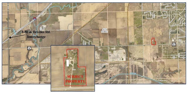
7280 E Us Highway 6, Minooka, IL 60447

Property Detail
7280 E Us Highway 6
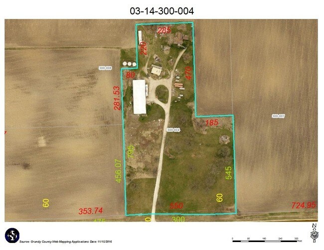
03-14-300-004
PT FRACT SW BEG 725'W OF SE COR W550' N795' E80' N220' E285' S470' E185' S545' TO POB SEC 14-34-8
Industrialgeneral
Grundy
B and X Area of moderate flood hazard, usually the area between the limits of the 100-year and 500-year floods.
Illinois
2024
9.66 AC
2024
Grundy County
000103
Chicago
1,320 SF
Chicago-Naperville-Elgin, IL-IN
NEARBY LISTINGS FOR SALE OR LEASE
DEMOGRAPHICS near 7280 E Us Highway 6
1 mile
3 mile
5 mile
2025 Total Population
3,763
20,960
28,981
2030 Population
3,817
21,374
29,671
Pop Growth 2025-2030
+ 1.44%
+ 1.98%
+ 2.38%
Average Age
34
37
38
2025 Total Households
1,262
6,882
9,725
HH Growth 2025-2030
+ 1.19%
+ 1.98%
+ 2.40%
Median Household Inc
$109,000
$114,155
$117,106
Avg Household Size
2.90
3.00
3.00
2025 Avg HH Vehicles
2.00
2.00
2.00
Median Home Value
$279,447
$314,031
$312,271
Median Year Built
2005
2002
2000
Nearby Places
Map Layers
Map Styles
 Street
 Aerial
Layers
 Traffic
 Biking
Places
Listings with unknown addresses are not visible on the map
- Restaurants
- Banks
- Shops
- Fitness
- Groceries
SALE & LEASE HISTORY
LISTING DATE
SALE/LEASE

Sep 05, 2017
For Sale
Oct 17, 2018
For Sale
Apr 29, 2019
For Sale
Nearby Properties
Address
Land Use
TOTAL SIZE
Lot Size
Zoning
Address
Land Use
TOTAL SIZE
Lot Size
Zoning
1,920 SF
119.06 AC
Address
Land Use
TOTAL SIZE
Lot Size
Zoning
138.51 AC
Address
Land Use
TOTAL SIZE
Lot Size
Zoning
132.70 AC
Address
Land Use
TOTAL SIZE
Lot Size
Zoning
79.57 AC
Address
Land Use
TOTAL SIZE
Lot Size
Zoning
364 SF
48.93 AC
Address
Land Use
TOTAL SIZE
Lot Size
Zoning
19.57 AC
Address
Land Use
TOTAL SIZE
Lot Size
Zoning
Address
Land Use
TOTAL SIZE
Lot Size
Zoning
160 AC
Address
Land Use
TOTAL SIZE
Lot Size
Zoning
1,034,100 SF
54.99 AC
Address
Land Use
TOTAL SIZE
Lot Size
Zoning
1,000,800 SF
24.66 AC
Address
Land Use
TOTAL SIZE
Lot Size
Zoning
15,600 SF
7.60 AC
Address
Land Use
TOTAL SIZE
Lot Size
Zoning
43.43 AC
Address
Land Use
TOTAL SIZE
Lot Size
Zoning
872,032 SF
43.10 AC
Address
Land Use
TOTAL SIZE
Lot Size
Zoning
598,380 SF
32.69 AC
Address
Land Use
TOTAL SIZE
Lot Size
Zoning
306,240 SF
19.99 AC
Address
Land Use
TOTAL SIZE
Lot Size
Zoning
456,860 SF
35.47 AC
Address
Land Use
TOTAL SIZE
Lot Size
Zoning
36.73 AC
Address
Land Use
TOTAL SIZE
Lot Size
Zoning
160 AC
Address
Land Use
TOTAL SIZE
Lot Size
Zoning
160 AC
Address
Land Use
TOTAL SIZE
Lot Size
Zoning
107,428 SF
17.69 AC
Address
Land Use
TOTAL SIZE
Lot Size
Zoning
29.48 AC
Address
Land Use
TOTAL SIZE
Lot Size
Zoning
134,300 SF
18.29 AC
Address
Land Use
TOTAL SIZE
Lot Size
Zoning
24.22 AC
Address
Land Use
TOTAL SIZE
Lot Size
Zoning
160 AC
Address
Land Use
TOTAL SIZE
Lot Size
Zoning
60,804 SF
7.29 AC
Address
Land Use
TOTAL SIZE
Lot Size
Zoning
77,000 SF
7.43 AC
Address
Land Use
TOTAL SIZE
Lot Size
Zoning
13.80 AC
Address
Land Use
TOTAL SIZE
Lot Size
Zoning
3,360 SF
43.42 AC
Address
Land Use
TOTAL SIZE
Lot Size
Zoning
59,138 SF
3.19 AC
The World's #1 Commercial Real Estate Marketplace
Connect with us
© 2026 CoStar Group
The information above has been obtained from sources believed reliable. While we do not doubt its accuracy we have not verified it and make no guarantee, warranty or representation about it. It is your responsibility to independently confirm its accuracy and completeness. Any projections, opinions, assumptions, or estimates used are for example only and do not represent the current or future performance of the property. The value of this transaction to you depends on tax and other factors which should be evaluated by your tax, financial, and legal advisors. You and your advisors should conduct a careful, independent investigation of the property to determine to your satisfaction the suitability of the property for your needs.