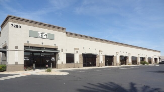
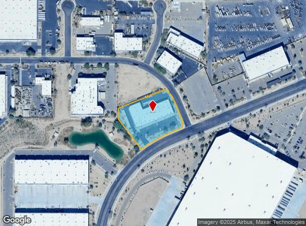
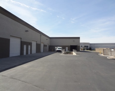
Property Record
7280 N Glen Harbor Blvd, Glendale, AZ 85307
Current Lease Availabilities
NEARBY LISTINGS FOR SALE OR LEASE
Property Detail
7280 N Glen Harbor Blvd
Phoenix-Mesa-Scottsdale, AZ
Sdms Real Estate Holdings Llc Mld
142-59-095
SDMS REAL ESTATE HOLDINGS LLC MLD MCR 1270-20
Warehouse
Maricopa
X
Arizona
04013C1695M
1
2025
2.28 AC
2025
Glendale
092720
Phoenix
30,084 SF
DEMOGRAPHICS near 7280 N Glen Harbor Blvd
1 Mile
3 Mile
5 Mile
2024 Total Population
2,446
68,258
256,765
2029 Population
2,649
75,079
279,077
Pop Growth 2024-2029
+ 8.30%
+ 9.99%
+ 8.69%
Average Age
40
39
38
2024 Total Households
919
25,118
87,082
HH Growth 2024-2029
+ 8.38%
+ 10.10%
+ 8.89%
Median Household Inc
$63,286
$70,233
$67,355
Avg Household Size
2.60
2.60
2.80
2024 Avg HH Vehicles
2.00
2.00
2.00
Median Home Value
$235,458
$286,305
$281,708
Median Year Built
1986
1996
1993
Nearby Places
- Restaurants
- Banks
- Shops
- Fitness
- Groceries
PUBLIC TRANSPORTATION
AIRPORT
Phoenix Sky Harbor International
DRIVE
WALK
Distance
Phoenix Sky Harbor International
34 min
24.5 mi
Nearby Properties
Address
Land Use
TOTAL SIZE
Lot Size
Zoning
Address
Land Use
TOTAL SIZE
Lot Size
Zoning
1,449,251 SF
25.30 AC
A1
Address
Land Use
TOTAL SIZE
Lot Size
Zoning
303,419 SF
31.47 AC
Address
Land Use
TOTAL SIZE
Lot Size
Zoning
127,011 SF
30.62 AC
PAD
Address
Land Use
TOTAL SIZE
Lot Size
Zoning
0.68 AC
Address
Land Use
TOTAL SIZE
Lot Size
Zoning
630,367 SF
13.50 AC
PAD
Address
Land Use
TOTAL SIZE
Lot Size
Zoning
74,628 SF
2.74 AC
PAD
Address
Land Use
TOTAL SIZE
Lot Size
Zoning
52.99 AC
Address
Land Use
TOTAL SIZE
Lot Size
Zoning
13,861 SF
3.40 AC
PAD
Address
Land Use
TOTAL SIZE
Lot Size
Zoning
242,300 SF
41.79 AC
C-C
Address
Land Use
TOTAL SIZE
Lot Size
Zoning
443,840 SF
37.94 AC
PAD
Address
Land Use
TOTAL SIZE
Lot Size
Zoning
687,993 SF
48.80 AC
Address
Land Use
TOTAL SIZE
Lot Size
Zoning
844,524 SF
130.66 AC
LUKEAFB
Address
Land Use
TOTAL SIZE
Lot Size
Zoning
533,718 SF
36.10 AC
PAD
Address
Land Use
TOTAL SIZE
Lot Size
Zoning
258,097 SF
32.53 AC
AG
Address
Land Use
TOTAL SIZE
Lot Size
Zoning
660,838 SF
29.28 AC
C2
Address
Land Use
TOTAL SIZE
Lot Size
Zoning
603,148 SF
13.63 AC
PAD
Address
Land Use
TOTAL SIZE
Lot Size
Zoning
185,870 SF
125.41 AC
S1
Address
Land Use
TOTAL SIZE
Lot Size
Zoning
135,052 SF
5.52 AC
PAD
Address
Land Use
TOTAL SIZE
Lot Size
Zoning
531,110 SF
124.24 AC
I-1
Address
Land Use
TOTAL SIZE
Lot Size
Zoning
269,894 SF
22.73 AC
R3A
Address
Land Use
TOTAL SIZE
Lot Size
Zoning
342,527 SF
16.52 AC
PAD
Address
Land Use
TOTAL SIZE
Lot Size
Zoning
330,321 SF
3.85 AC
PAD
Address
Land Use
TOTAL SIZE
Lot Size
Zoning
637,538 SF
9.74 AC
Address
Land Use
TOTAL SIZE
Lot Size
Zoning
334,769 SF
12.01 AC
Address
Land Use
TOTAL SIZE
Lot Size
Zoning
4,742 SF
1.18 AC
PAD
Address
Land Use
TOTAL SIZE
Lot Size
Zoning
409,017 SF
14.30 AC
Address
Land Use
TOTAL SIZE
Lot Size
Zoning
291,028 SF
20.62 AC
Address
Land Use
TOTAL SIZE
Lot Size
Zoning
131,031 SF
26.44 AC
R-43
Address
Land Use
TOTAL SIZE
Lot Size
Zoning
327,311 SF
21.14 AC
RM-1
Address
Land Use
TOTAL SIZE
Lot Size
Zoning
321,976 SF
13 AC
R-43
The World's #1 Commercial Real Estate Marketplace
Connect with us
© 2025 CoStar Group
The information above has been obtained from sources believed reliable. While we do not doubt its accuracy we have not verified it and make no guarantee, warranty or representation about it. It is your responsibility to independently confirm its accuracy and completeness. Any projections, opinions, assumptions, or estimates used are for example only and do not represent the current or future performance of the property. The value of this transaction to you depends on tax and other factors which should be evaluated by your tax, financial, and legal advisors. You and your advisors should conduct a careful, independent investigation of the property to determine to your satisfaction the suitability of the property for your needs.