Property Record
7281 Alameda Ave, El Paso, TX 79915

NEARBY LISTINGS FOR SALE OR LEASE
Property Detail
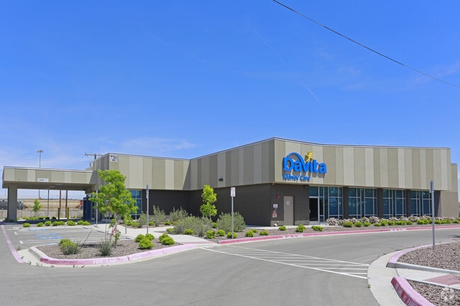
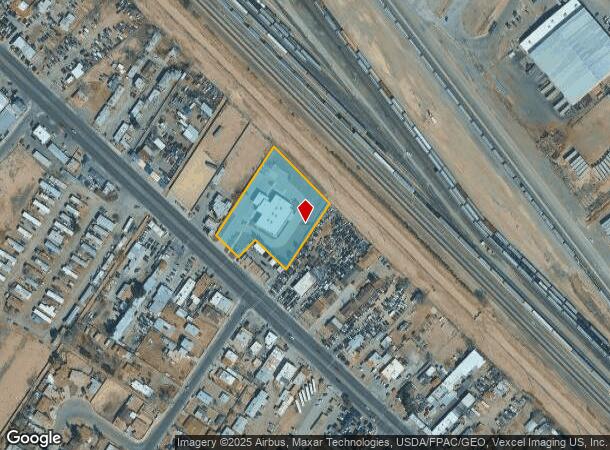
7281 Alameda Ave
El Paso, TX
Davita Alameda
D122-999-0010-0100
BLK 1 DAVITA ALAMEDA LOT 1
Commercialnec
El Paso
X
Texas
4802140044C
1
2024
1.78 AC
2025
East
003702
El Paso
10,006 SF
DEMOGRAPHICS near 7281 Alameda Ave
1 Mile
3 Mile
5 Mile
2024 Total Population
10,027
81,319
188,948
2029 Population
10,125
82,080
190,613
Pop Growth 2024-2029
+ 0.98%
+ 0.94%
+ 0.88%
Average Age
40
40
39
2024 Total Households
3,665
30,669
69,804
HH Growth 2024-2029
+ 0.98%
+ 0.95%
+ 0.84%
Median Household Inc
$27,773
$36,621
$40,546
Avg Household Size
2.60
2.60
2.60
2024 Avg HH Vehicles
2.00
2.00
2.00
Median Home Value
$84,595
$127,396
$137,072
Median Year Built
1964
1966
1971
Nearby Places
Map Layers
Map Styles
 Street
 Aerial
- Restaurants
- Banks
- Shops
- Fitness
- Groceries
PUBLIC TRANSPORTATION
AIRPORT
El Paso International
DRIVE
WALK
Distance
El Paso International
23 min
10.8 mi
Freight Ports
Port of Corpus Christi
DRIVE
WALK
Distance
Port of Corpus Christi
675 min
689.1 mi
SALE & LEASE HISTORY
LISTING DATE
SALE/LEASE

Nov 20, 2023
For Lease
May 26, 2023
For Sale
Jun 30, 2017
For Sale
Aug 04, 2017
For Sale
Apr 28, 2022
For Sale
Nearby Properties
Address
Land Use
TOTAL SIZE
Lot Size
Zoning
Address
Land Use
TOTAL SIZE
Lot Size
Zoning
75,601 SF
495.64 AC
M3
Address
Land Use
TOTAL SIZE
Lot Size
Zoning
600,211 SF
114.73 AC
RF
Address
Land Use
TOTAL SIZE
Lot Size
Zoning
753,996 SF
23.50 AC
C4
Address
Land Use
TOTAL SIZE
Lot Size
Zoning
1,122,782 SF
55.24 AC
C4
Address
Land Use
TOTAL SIZE
Lot Size
Zoning
1 SF
M1
Address
Land Use
TOTAL SIZE
Lot Size
Zoning
1 SF
214 AC
M3
Address
Land Use
TOTAL SIZE
Lot Size
Zoning
380,811 SF
22.75 AC
M1
Address
Land Use
TOTAL SIZE
Lot Size
Zoning
343,190 SF
31.84 AC
C4
Address
Land Use
TOTAL SIZE
Lot Size
Zoning
1 SF
Address
Land Use
TOTAL SIZE
Lot Size
Zoning
289.07 AC
Address
Land Use
TOTAL SIZE
Lot Size
Zoning
377,168 SF
8.40 AC
C1
Address
Land Use
TOTAL SIZE
Lot Size
Zoning
210,541 SF
2.45 AC
C3S
Address
Land Use
TOTAL SIZE
Lot Size
Zoning
125,896 SF
8.67 AC
R3
Address
Land Use
TOTAL SIZE
Lot Size
Zoning
206,726 SF
24.42 AC
M1S
Address
Land Use
TOTAL SIZE
Lot Size
Zoning
196,860 SF
10.15 AC
C4
Address
Land Use
TOTAL SIZE
Lot Size
Zoning
272,601 SF
14.97 AC
AO
Address
Land Use
TOTAL SIZE
Lot Size
Zoning
197,902 SF
30 AC
R4
Address
Land Use
TOTAL SIZE
Lot Size
Zoning
259,968 SF
10.54 AC
AO
Address
Land Use
TOTAL SIZE
Lot Size
Zoning
184,016 SF
14.17 AC
C4
Address
Land Use
TOTAL SIZE
Lot Size
Zoning
269,974 SF
15.87 AC
A2S
Address
Land Use
TOTAL SIZE
Lot Size
Zoning
235,213 SF
11.98 AC
A3O
Address
Land Use
TOTAL SIZE
Lot Size
Zoning
333,673 SF
15 AC
AO
Address
Land Use
TOTAL SIZE
Lot Size
Zoning
137,378 SF
10.05 AC
C3S
Address
Land Use
TOTAL SIZE
Lot Size
Zoning
83,251 SF
2.43 AC
M1
Address
Land Use
TOTAL SIZE
Lot Size
Zoning
109,578 SF
17.84 AC
RF
Address
Land Use
TOTAL SIZE
Lot Size
Zoning
341,541 SF
22.51 AC
A2
Address
Land Use
TOTAL SIZE
Lot Size
Zoning
54,062 SF
4.92 AC
R4
Address
Land Use
TOTAL SIZE
Lot Size
Zoning
87,042 SF
2.94 AC
C4S
Address
Land Use
TOTAL SIZE
Lot Size
Zoning
307,575 SF
37.26 AC
Address
Land Use
TOTAL SIZE
Lot Size
Zoning
54,911 SF
2 AC
The World's #1 Commercial Real Estate Marketplace
Connect with us
© 2025 CoStar Group
The information above has been obtained from sources believed reliable. While we do not doubt its accuracy we have not verified it and make no guarantee, warranty or representation about it. It is your responsibility to independently confirm its accuracy and completeness. Any projections, opinions, assumptions, or estimates used are for example only and do not represent the current or future performance of the property. The value of this transaction to you depends on tax and other factors which should be evaluated by your tax, financial, and legal advisors. You and your advisors should conduct a careful, independent investigation of the property to determine to your satisfaction the suitability of the property for your needs.