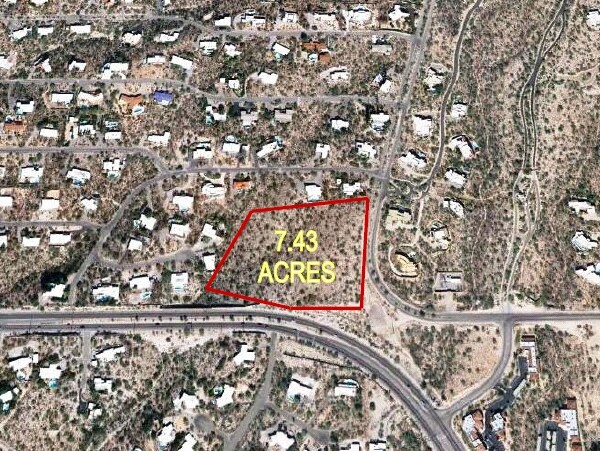
Property Record
7281 N Skyline Dr, Tucson, AZ 85718

NEARBY LISTINGS FOR SALE OR LEASE
Property Detail
7281 N Skyline Dr
Tucson, AZ
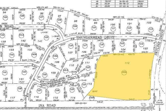
Shadow Roc
220-19-123A
SHADOW ROC LOT 112 EXC SWLY TRI PTN
Commercialnec
Pima
X
Arizona
04019C1680L
112
0
7.43 AC
2025
Foothills
004713
Tucson
36,728 SF
DEMOGRAPHICS near 7281 N Skyline Dr
1 Mile
3 Mile
5 Mile
2024 Total Population
3,623
31,477
127,731
2029 Population
3,810
32,619
132,410
Pop Growth 2024-2029
+ 5.16%
+ 3.63%
+ 3.66%
Average Age
52
47
44
2024 Total Households
1,591
14,706
59,264
HH Growth 2024-2029
+ 5.47%
+ 3.64%
+ 3.71%
Median Household Inc
$156,996
$94,359
$65,737
Avg Household Size
2.20
2.10
2.10
2024 Avg HH Vehicles
2.00
2.00
2.00
Median Home Value
$767,552
$491,285
$348,303
Median Year Built
1984
1979
1983
Nearby Places
Map Layers
Map Styles
 Street
 Aerial
- Restaurants
- Banks
- Shops
- Fitness
- Groceries
PUBLIC TRANSPORTATION
COMMUTER RAIL
Tucson Amtrak Station (Sunset Limited - Amtrak, Texas Eagle - Amtrak)
DRIVE
WALK
Distance
Tucson Amtrak Station (Sunset Limited - Amtrak, Texas Eagle - Amtrak)
20 min
9.6 mi
AIRPORT
Tucson International
DRIVE
WALK
Distance
Tucson International
35 min
16.7 mi
Freight Ports
Port of San Diego
DRIVE
WALK
Distance
Port of San Diego
435 min
405.7 mi
Nearby Properties
Address
Land Use
TOTAL SIZE
Lot Size
Zoning
Address
Land Use
TOTAL SIZE
Lot Size
Zoning
92,660 SF
32.35 AC
CR1
Address
Land Use
TOTAL SIZE
Lot Size
Zoning
683,366 SF
44.13 AC
Address
Land Use
TOTAL SIZE
Lot Size
Zoning
259,575 SF
29.21 AC
CB1
Address
Land Use
TOTAL SIZE
Lot Size
Zoning
272,429 SF
36.97 AC
R1144
Address
Land Use
TOTAL SIZE
Lot Size
Zoning
327,855 SF
20.03 AC
CR5
Address
Land Use
TOTAL SIZE
Lot Size
Zoning
22,114 SF
49.39 AC
CR1
Address
Land Use
TOTAL SIZE
Lot Size
Zoning
375,887 SF
28.70 AC
CR4
Address
Land Use
TOTAL SIZE
Lot Size
Zoning
388,226 SF
22 AC
CR5
Address
Land Use
TOTAL SIZE
Lot Size
Zoning
352,158 SF
15.89 AC
Address
Land Use
TOTAL SIZE
Lot Size
Zoning
222,779 SF
8.83 AC
CR5
Address
Land Use
TOTAL SIZE
Lot Size
Zoning
81,097 SF
7.16 AC
CB1
Address
Land Use
TOTAL SIZE
Lot Size
Zoning
89,041 SF
35.51 AC
Address
Land Use
TOTAL SIZE
Lot Size
Zoning
284,407 SF
15.04 AC
Address
Land Use
TOTAL SIZE
Lot Size
Zoning
223,640 SF
18.06 AC
CB1
Address
Land Use
TOTAL SIZE
Lot Size
Zoning
279,055 SF
18.03 AC
CR4
Address
Land Use
TOTAL SIZE
Lot Size
Zoning
200,311 SF
36.08 AC
CR1
Address
Land Use
TOTAL SIZE
Lot Size
Zoning
172,755 SF
17.57 AC
SR
Address
Land Use
TOTAL SIZE
Lot Size
Zoning
99,330 SF
4.28 AC
TR
Address
Land Use
TOTAL SIZE
Lot Size
Zoning
80,891 SF
7.14 AC
TR
Address
Land Use
TOTAL SIZE
Lot Size
Zoning
115,748 SF
8.87 AC
CB1
Address
Land Use
TOTAL SIZE
Lot Size
Zoning
166,630 SF
9.01 AC
RS
Address
Land Use
TOTAL SIZE
Lot Size
Zoning
89,184 SF
24.13 AC
CR1
Address
Land Use
TOTAL SIZE
Lot Size
Zoning
166,072 SF
10.97 AC
TR
Address
Land Use
TOTAL SIZE
Lot Size
Zoning
45,000 SF
8.50 AC
C1
Address
Land Use
TOTAL SIZE
Lot Size
Zoning
66,608 SF
3.97 AC
CB1
Address
Land Use
TOTAL SIZE
Lot Size
Zoning
37,900 SF
4.49 AC
CB1
Address
Land Use
TOTAL SIZE
Lot Size
Zoning
179,984 SF
11.07 AC
CR1
Address
Land Use
TOTAL SIZE
Lot Size
Zoning
152,132 SF
8.88 AC
CR5
Address
Land Use
TOTAL SIZE
Lot Size
Zoning
109,408 SF
5.71 AC
R1144
Address
Land Use
TOTAL SIZE
Lot Size
Zoning
93,318 SF
4.50 AC
TR
The World's #1 Commercial Real Estate Marketplace
Connect with us
© 2025 CoStar Group
The information above has been obtained from sources believed reliable. While we do not doubt its accuracy we have not verified it and make no guarantee, warranty or representation about it. It is your responsibility to independently confirm its accuracy and completeness. Any projections, opinions, assumptions, or estimates used are for example only and do not represent the current or future performance of the property. The value of this transaction to you depends on tax and other factors which should be evaluated by your tax, financial, and legal advisors. You and your advisors should conduct a careful, independent investigation of the property to determine to your satisfaction the suitability of the property for your needs.