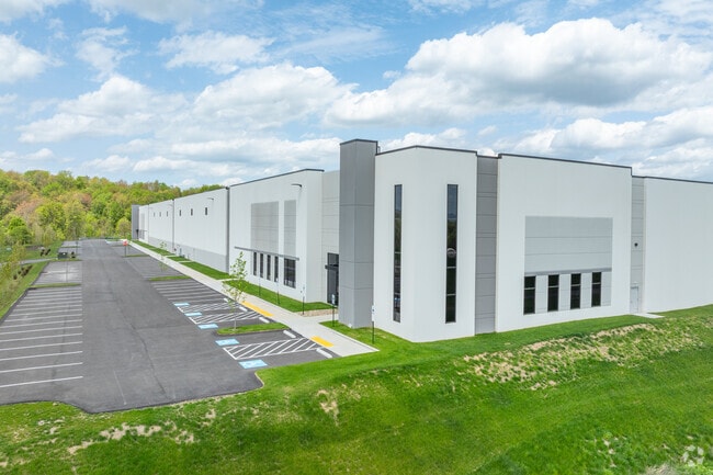
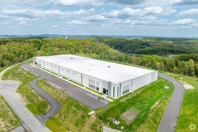
Property Record
729 Excel Dr, Hunker, PA 15639

Property Detail
729 Excel Dr
Pittsburgh, PA
LOT 13, BLDG WCIDC DISTR PK PH II-PCL-B PL
50-41-00-0-166
WESTMORELAND
Commercialofficeresidentialmixeduse
Pennsylvania
B and X Area of moderate flood hazard, usually the area between the limits of the 100-year and 500-year floods.
13
2025
13.39 AC
2026
Westmoreland County
804902
Pittsburgh
NEARBY LISTINGS FOR SALE OR LEASE
DEMOGRAPHICS near 729 Excel Dr
1 mile
3 mile
5 mile
2025 Total Population
710
8,664
23,785
2030 Population
689
8,541
23,394
Pop Growth 2025-2030
(2.96%)
(1.42%)
(1.64%)
Average Age
45
44
45
2025 Total Households
312
3,867
10,560
HH Growth 2025-2030
(3.21%)
(1.55%)
(1.72%)
Median Household Inc
$72,672
$67,801
$66,096
Avg Household Size
2.20
2.20
2.20
2025 Avg HH Vehicles
2.00
2.00
2.00
Median Home Value
$170,833
$199,262
$181,302
Median Year Built
1984
1973
1966
Nearby Places
Map Layers
Map Styles
 Street
 Aerial
Layers
 Traffic
 Biking
Places
Listings with unknown addresses are not visible on the map
- Restaurants
- Banks
- Shops
- Fitness
- Groceries
PUBLIC TRANSPORTATION
AIRPORT
Arnold Palmer Regional
Drive
Walk
Distance
Arnold Palmer Regional
34 min
17.6 mi
Freight Ports
Port of Baltimore
Drive
Walk
Distance
Port of Baltimore
257 min
213.8 mi
SALE & LEASE HISTORY
LISTING DATE
SALE/LEASE

Nov 12, 2020
For Lease
Nearby Properties
Address
Land Use
TOTAL SIZE
Lot Size
Zoning
Address
Land Use
TOTAL SIZE
Lot Size
Zoning
168.67 AC
Address
Land Use
TOTAL SIZE
Lot Size
Zoning
37.67 AC
Address
Land Use
TOTAL SIZE
Lot Size
Zoning
44.36 AC
Address
Land Use
TOTAL SIZE
Lot Size
Zoning
21.91 AC
Address
Land Use
TOTAL SIZE
Lot Size
Zoning
208,800 SF
31.20 AC
Address
Land Use
TOTAL SIZE
Lot Size
Zoning
32.50 AC
Address
Land Use
TOTAL SIZE
Lot Size
Zoning
Address
Land Use
TOTAL SIZE
Lot Size
Zoning
14.79 AC
Address
Land Use
TOTAL SIZE
Lot Size
Zoning
326,000 SF
109.40 AC
Address
Land Use
TOTAL SIZE
Lot Size
Zoning
35.40 AC
Address
Land Use
TOTAL SIZE
Lot Size
Zoning
57.96 AC
Address
Land Use
TOTAL SIZE
Lot Size
Zoning
342.14 AC
Address
Land Use
TOTAL SIZE
Lot Size
Zoning
11.95 AC
Address
Land Use
TOTAL SIZE
Lot Size
Zoning
57.80 AC
Address
Land Use
TOTAL SIZE
Lot Size
Zoning
Address
Land Use
TOTAL SIZE
Lot Size
Zoning
9.23 AC
Address
Land Use
TOTAL SIZE
Lot Size
Zoning
Address
Land Use
TOTAL SIZE
Lot Size
Zoning
11.22 AC
Address
Land Use
TOTAL SIZE
Lot Size
Zoning
Address
Land Use
TOTAL SIZE
Lot Size
Zoning
1,924 SF
6.55 AC
Address
Land Use
TOTAL SIZE
Lot Size
Zoning
11.95 AC
Address
Land Use
TOTAL SIZE
Lot Size
Zoning
90,464 SF
21 AC
Address
Land Use
TOTAL SIZE
Lot Size
Zoning
54,542 SF
38.84 AC
Address
Land Use
TOTAL SIZE
Lot Size
Zoning
81,055 SF
6.15 AC
Address
Land Use
TOTAL SIZE
Lot Size
Zoning
11.28 AC
Address
Land Use
TOTAL SIZE
Lot Size
Zoning
5.10 AC
Address
Land Use
TOTAL SIZE
Lot Size
Zoning
43,432 SF
4.18 AC
Address
Land Use
TOTAL SIZE
Lot Size
Zoning
28.93 AC
Address
Land Use
TOTAL SIZE
Lot Size
Zoning
7.40 AC
The World's #1 Commercial Real Estate Marketplace
Connect with us
© 2026 CoStar Group
The information above has been obtained from sources believed reliable. While we do not doubt its accuracy we have not verified it and make no guarantee, warranty or representation about it. It is your responsibility to independently confirm its accuracy and completeness. Any projections, opinions, assumptions, or estimates used are for example only and do not represent the current or future performance of the property. The value of this transaction to you depends on tax and other factors which should be evaluated by your tax, financial, and legal advisors. You and your advisors should conduct a careful, independent investigation of the property to determine to your satisfaction the suitability of the property for your needs.