Property Record
729 Ne 7Th St, Grants Pass, OR 97526
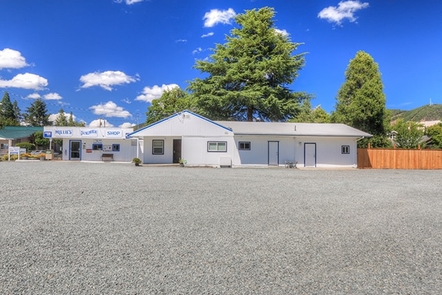
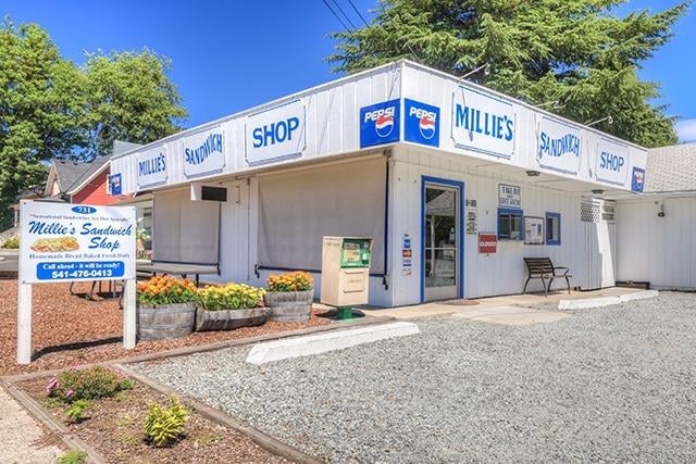
Property Detail
729 Ne 7Th St
R310445
ACRES 0.25
Commercialacreage
Josephine
GC
Oregon
B and X Area of moderate flood hazard, usually the area between the limits of the 100-year and 500-year floods.
0.25 AC
2024
Medford/Grants Pass
2025
Other Market Areas
360500
Grants Pass, OR
NEARBY LISTINGS FOR SALE OR LEASE
DEMOGRAPHICS near 729 Ne 7Th St
1 mile
3 mile
5 mile
2025 Total Population
11,506
39,576
54,668
2030 Population
11,303
39,337
54,356
Pop Growth 2025-2030
(1.76%)
(0.60%)
(0.57%)
Average Age
41
43
44
2025 Total Households
4,821
16,053
22,162
HH Growth 2025-2030
(1.99%)
(0.75%)
(0.67%)
Median Household Inc
$49,908
$62,111
$64,829
Avg Household Size
2.30
2.30
2.40
2025 Avg HH Vehicles
2.00
2.00
2.00
Median Home Value
$349,109
$379,590
$398,086
Median Year Built
1969
1979
1982
Nearby Places
Map Layers
Map Styles
 Street
 Aerial
Transit
 Traffic
 Biking
Places
Listings with unknown addresses are not visible on the map
- Restaurants
- Banks
- Shops
- Fitness
- Groceries
PUBLIC TRANSPORTATION
AIRPORT
Rogue Valley International - Medford
Drive
Walk
Distance
Rogue Valley International - Medford
36 min
28.7 mi
Freight Ports
Port of Coos Bay, OR
Drive
Walk
Distance
Port of Coos Bay, OR
182 min
136.8 mi
SALE & LEASE HISTORY
LISTING DATE
SALE/LEASE

Sep 24, 2016
For Sale
May 10, 2017
For Sale
Jul 24, 2017
For Sale
Nearby Properties
Address
Land Use
TOTAL SIZE
Lot Size
Zoning
Address
Land Use
TOTAL SIZE
Lot Size
Zoning
1,324,134 SF
9.03 AC
R-1-6
Address
Land Use
TOTAL SIZE
Lot Size
Zoning
74,405 SF
11.34 AC
GC
Address
Land Use
TOTAL SIZE
Lot Size
Zoning
49,752 SF
11.21 AC
R-2
Address
Land Use
TOTAL SIZE
Lot Size
Zoning
13,764 SF
3.32 AC
R-2
Address
Land Use
TOTAL SIZE
Lot Size
Zoning
11.54 AC
I
Address
Land Use
TOTAL SIZE
Lot Size
Zoning
360 SF
18.68 AC
I
Address
Land Use
TOTAL SIZE
Lot Size
Zoning
4,888 SF
2.58 AC
R-4,GC
Address
Land Use
TOTAL SIZE
Lot Size
Zoning
8,706 SF
13.73 AC
GC
Address
Land Use
TOTAL SIZE
Lot Size
Zoning
3.93 AC
R-3
Address
Land Use
TOTAL SIZE
Lot Size
Zoning
7.31 AC
MP
Address
Land Use
TOTAL SIZE
Lot Size
Zoning
3.56 AC
GC
Address
Land Use
TOTAL SIZE
Lot Size
Zoning
Address
Land Use
TOTAL SIZE
Lot Size
Zoning
59,342 SF
4.14 AC
BP
Address
Land Use
TOTAL SIZE
Lot Size
Zoning
47,766 SF
2.02 AC
GC
Address
Land Use
TOTAL SIZE
Lot Size
Zoning
9.70 AC
BP
Address
Land Use
TOTAL SIZE
Lot Size
Zoning
8.48 AC
BP
Address
Land Use
TOTAL SIZE
Lot Size
Zoning
4,568 SF
5.71 AC
R-2
Address
Land Use
TOTAL SIZE
Lot Size
Zoning
34,446 SF
2.62 AC
IP
Address
Land Use
TOTAL SIZE
Lot Size
Zoning
112,259 SF
6.40 AC
GC
Address
Land Use
TOTAL SIZE
Lot Size
Zoning
76,830 SF
16.12 AC
R-3
Address
Land Use
TOTAL SIZE
Lot Size
Zoning
1,792 SF
6.15 AC
R-2
Address
Land Use
TOTAL SIZE
Lot Size
Zoning
66,148 SF
2.63 AC
I
Address
Land Use
TOTAL SIZE
Lot Size
Zoning
25,131 SF
5.22 AC
GC
Address
Land Use
TOTAL SIZE
Lot Size
Zoning
47,060 SF
10.65 AC
R-1-6
Address
Land Use
TOTAL SIZE
Lot Size
Zoning
111,774 SF
6.93 AC
R-3
Address
Land Use
TOTAL SIZE
Lot Size
Zoning
142,166 SF
12.41 AC
I
Address
Land Use
TOTAL SIZE
Lot Size
Zoning
9.70 AC
BP
Address
Land Use
TOTAL SIZE
Lot Size
Zoning
26,000 SF
9.12 AC
R-1-8
Address
Land Use
TOTAL SIZE
Lot Size
Zoning
20,000 SF
19.04 AC
R-1-8
Address
Land Use
TOTAL SIZE
Lot Size
Zoning
1,222 SF
22.68 AC
R-1-8
The World's #1 Commercial Real Estate Marketplace
Connect with us
© 2026 CoStar Group
The information above has been obtained from sources believed reliable. While we do not doubt its accuracy we have not verified it and make no guarantee, warranty or representation about it. It is your responsibility to independently confirm its accuracy and completeness. Any projections, opinions, assumptions, or estimates used are for example only and do not represent the current or future performance of the property. The value of this transaction to you depends on tax and other factors which should be evaluated by your tax, financial, and legal advisors. You and your advisors should conduct a careful, independent investigation of the property to determine to your satisfaction the suitability of the property for your needs.