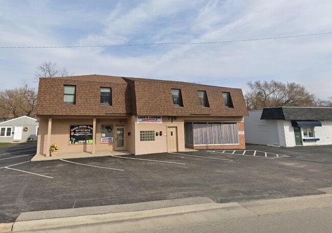
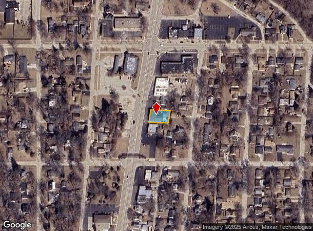
Property Record
729 Sheridan Rd, Winthrop Harbor, IL 60096
Current Lease Availabilities
NEARBY LISTINGS FOR SALE OR LEASE
Property Detail
729 Sheridan Rd
Chicago-Naperville-Elgin, IL-IN-WI
Winthrop Harbor
04-10-110-004
RESUB OF PTS SUB OF LT6 WINTHROP HARBOR,PT LTB BLK8 BEG W LN 398S OF S LN MAIN ST, E // TO SD ST TO E LN SD LT,NLY ALG E LN 71.95, W TO PNT IN W LN 73.9NLY OF POB,SLY TO POB LOT
Commercialbuilding
Lake
X
Illinois
17097C0077L
6,b
2023
0.18 AC
2024
Far North
860103
Chicago
5,377 SF
DEMOGRAPHICS near 729 Sheridan Rd
1 Mile
3 Mile
5 Mile
2024 Total Population
5,129
31,810
65,982
2029 Population
5,004
31,522
65,373
Pop Growth 2024-2029
(2.44%)
(0.91%)
(0.92%)
Average Age
43
39
40
2024 Total Households
2,040
11,265
24,038
HH Growth 2024-2029
(2.75%)
(1.17%)
(1.09%)
Median Household Inc
$83,139
$72,400
$74,032
Avg Household Size
2.50
2.70
2.70
2024 Avg HH Vehicles
2.00
2.00
2.00
Median Home Value
$213,417
$188,331
$207,370
Median Year Built
1973
1971
1977
Nearby Places
- Restaurants
- Banks
- Shops
- Fitness
- Groceries
PUBLIC TRANSPORTATION
TRANSIT/SUBWAY
Winthrop Harbor Station (Union Pacific North Line - Northeast Illinois Regional Commuter Railroad (Metra))
DRIVE
WALK
Distance
Winthrop Harbor Station (Union Pacific North Line - Northeast Illinois Regional Commuter Railroad (Metra))
2 min
8 min
0.4 mi
COMMUTER RAIL
Winthrop Harbor Station (Union Pacific North Line - Northeast Illinois Regional Commuter Railroad (Metra))
DRIVE
WALK
Distance
Winthrop Harbor Station (Union Pacific North Line - Northeast Illinois Regional Commuter Railroad (Metra))
2 min
8 min
0.4 mi
Zion Station (Union Pacific North Line - Northeast Illinois Regional Commuter Railroad (Metra))
DRIVE
WALK
Distance
Zion Station (Union Pacific North Line - Northeast Illinois Regional Commuter Railroad (Metra))
7 min
2.6 mi
AIRPORT
General Mitchell International
DRIVE
WALK
Distance
General Mitchell International
53 min
40.5 mi
Chicago O'Hare International
DRIVE
WALK
Distance
Chicago O'Hare International
61 min
45.7 mi
Freight Ports
Port Milwaukee
DRIVE
WALK
Distance
Port Milwaukee
58 min
44.4 mi
Nearby Properties
Address
Land Use
TOTAL SIZE
Lot Size
Zoning
Address
Land Use
TOTAL SIZE
Lot Size
Zoning
32,000 SF
0.92 AC
Address
Land Use
TOTAL SIZE
Lot Size
Zoning
5,690 SF
93.61 AC
Address
Land Use
TOTAL SIZE
Lot Size
Zoning
1,200 SF
17.69 AC
Address
Land Use
TOTAL SIZE
Lot Size
Zoning
244,800 SF
23.32 AC
Address
Land Use
TOTAL SIZE
Lot Size
Zoning
215,773 SF
20.50 AC
Address
Land Use
TOTAL SIZE
Lot Size
Zoning
96,384 SF
8.73 AC
Address
Land Use
TOTAL SIZE
Lot Size
Zoning
320,050 SF
0.96 AC
Address
Land Use
TOTAL SIZE
Lot Size
Zoning
224,750 SF
15.11 AC
Address
Land Use
TOTAL SIZE
Lot Size
Zoning
66,140 SF
0.88 AC
Address
Land Use
TOTAL SIZE
Lot Size
Zoning
0.24 AC
Address
Land Use
TOTAL SIZE
Lot Size
Zoning
0.36 AC
Address
Land Use
TOTAL SIZE
Lot Size
Zoning
10,656 SF
4.37 AC
Address
Land Use
TOTAL SIZE
Lot Size
Zoning
34,476 SF
0.24 AC
Address
Land Use
TOTAL SIZE
Lot Size
Zoning
0.40 AC
Address
Land Use
TOTAL SIZE
Lot Size
Zoning
55,087 SF
0.57 AC
Address
Land Use
TOTAL SIZE
Lot Size
Zoning
85,238 SF
1.14 AC
Address
Land Use
TOTAL SIZE
Lot Size
Zoning
192,376 SF
8.28 AC
Address
Land Use
TOTAL SIZE
Lot Size
Zoning
90,234 SF
5.69 AC
Address
Land Use
TOTAL SIZE
Lot Size
Zoning
0.24 AC
Address
Land Use
TOTAL SIZE
Lot Size
Zoning
65,440 SF
0.16 AC
Address
Land Use
TOTAL SIZE
Lot Size
Zoning
44,900 SF
3.83 AC
Address
Land Use
TOTAL SIZE
Lot Size
Zoning
15.20 AC
Address
Land Use
TOTAL SIZE
Lot Size
Zoning
0.24 AC
Address
Land Use
TOTAL SIZE
Lot Size
Zoning
37,068 SF
1.70 AC
Address
Land Use
TOTAL SIZE
Lot Size
Zoning
59,580 SF
3.33 AC
Address
Land Use
TOTAL SIZE
Lot Size
Zoning
48,134 SF
5.01 AC
Address
Land Use
TOTAL SIZE
Lot Size
Zoning
7.08 AC
Address
Land Use
TOTAL SIZE
Lot Size
Zoning
66,035 SF
0.24 AC
Address
Land Use
TOTAL SIZE
Lot Size
Zoning
60,156 SF
3.45 AC
Address
Land Use
TOTAL SIZE
Lot Size
Zoning
51,188 SF
7.73 AC
The World's #1 Commercial Real Estate Marketplace
Connect with us
© 2025 CoStar Group
The information above has been obtained from sources believed reliable. While we do not doubt its accuracy we have not verified it and make no guarantee, warranty or representation about it. It is your responsibility to independently confirm its accuracy and completeness. Any projections, opinions, assumptions, or estimates used are for example only and do not represent the current or future performance of the property. The value of this transaction to you depends on tax and other factors which should be evaluated by your tax, financial, and legal advisors. You and your advisors should conduct a careful, independent investigation of the property to determine to your satisfaction the suitability of the property for your needs.