Property Record
729 Top Chord Way Way, , NC
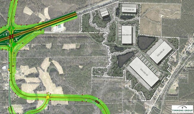
Property Detail
729 Top Chord Way Way
Durham-Chapel Hill, NC
LOT 1; PARCEL 2 AC 193.41 BK 2021 PG 277
90707
CHATHAM
Vacantlandnec
North Carolina
IND-L
1
AE The base floodplain where base flood elevations are provided. AE Zones are now used on new format FIRMs instead of A1-A30 Zones.
43.58 AC
2025
Chatham County
2025
Raleigh/Durham
020702
NEARBY LISTINGS FOR SALE OR LEASE
DEMOGRAPHICS near 729 Top Chord Way Way
1 mile
3 mile
5 mile
2025 Total Population
120
1,638
3,493
2030 Population
130
1,782
3,816
Pop Growth 2025-2030
+ 8.33%
+ 8.79%
+ 9.25%
Average Age
44
45
44
2025 Total Households
50
644
1,351
HH Growth 2025-2030
+ 8.00%
+ 9.01%
+ 9.47%
Median Household Inc
$116,071
$68,863
$70,016
Avg Household Size
2.40
2.50
2.50
2025 Avg HH Vehicles
3.00
3.00
3.00
Median Home Value
$406,667
$423,039
$388,690
Median Year Built
1990
1994
1993
Nearby Places
Map Layers
Map Styles
 Street
 Aerial
Transit
 Traffic
 Biking
Places
Listings with unknown addresses are not visible on the map
- Restaurants
- Banks
- Shops
- Fitness
- Groceries
PUBLIC TRANSPORTATION
AIRPORT
Raleigh-Durham International
Drive
Walk
Distance
Raleigh-Durham International
35 min
28.2 mi
Freight Ports
Port of Wilmington
Drive
Walk
Distance
Port of Wilmington
177 min
156.6 mi
SALE & LEASE HISTORY
LISTING DATE
SALE/LEASE

Oct 21, 2022
For Sale
Nearby Properties
Address
Land Use
TOTAL SIZE
Lot Size
Zoning
Address
Land Use
TOTAL SIZE
Lot Size
Zoning
338,013 SF
58.10 AC
IND-H
Address
Land Use
TOTAL SIZE
Lot Size
Zoning
234,462 SF
106.79 AC
IND-H
Address
Land Use
TOTAL SIZE
Lot Size
Zoning
248.05 AC
R-80
Address
Land Use
TOTAL SIZE
Lot Size
Zoning
280,718 SF
296.13 AC
IND-H
Address
Land Use
TOTAL SIZE
Lot Size
Zoning
855.31 AC
IND-H
Address
Land Use
TOTAL SIZE
Lot Size
Zoning
252,798 SF
103.69 AC
IND-H
Address
Land Use
TOTAL SIZE
Lot Size
Zoning
38,640 SF
38.35 AC
CD-CB
Address
Land Use
TOTAL SIZE
Lot Size
Zoning
181,419 SF
107.89 AC
IND-H
Address
Land Use
TOTAL SIZE
Lot Size
Zoning
231.24 AC
IND-H
Address
Land Use
TOTAL SIZE
Lot Size
Zoning
220.64 AC
IND-H
Address
Land Use
TOTAL SIZE
Lot Size
Zoning
255.97 AC
IND-H
Address
Land Use
TOTAL SIZE
Lot Size
Zoning
151.61 AC
R-1
Address
Land Use
TOTAL SIZE
Lot Size
Zoning
11,360 SF
30.41 AC
IND-L
Address
Land Use
TOTAL SIZE
Lot Size
Zoning
11,928 SF
28.69 AC
IND-H
Address
Land Use
TOTAL SIZE
Lot Size
Zoning
5,602 SF
22.14 AC
CU-OI
Address
Land Use
TOTAL SIZE
Lot Size
Zoning
13,600 SF
10.01 AC
B-1
Address
Land Use
TOTAL SIZE
Lot Size
Zoning
20,820 SF
15.08 AC
CU-IND-H
Address
Land Use
TOTAL SIZE
Lot Size
Zoning
868 SF
193.41 AC
R-1
Address
Land Use
TOTAL SIZE
Lot Size
Zoning
123.56 AC
IND-H
Address
Land Use
TOTAL SIZE
Lot Size
Zoning
22,976 SF
10.06 AC
CD-NB
Address
Land Use
TOTAL SIZE
Lot Size
Zoning
4,834 SF
8.30 AC
OI
Address
Land Use
TOTAL SIZE
Lot Size
Zoning
1,428 SF
10.35 AC
CU-B-1
Address
Land Use
TOTAL SIZE
Lot Size
Zoning
5,900 SF
9.47 AC
B-1
Address
Land Use
TOTAL SIZE
Lot Size
Zoning
65.23 AC
R-1
Address
Land Use
TOTAL SIZE
Lot Size
Zoning
12.30 AC
R-1
Address
Land Use
TOTAL SIZE
Lot Size
Zoning
4,952 SF
28.19 AC
R-1
Address
Land Use
TOTAL SIZE
Lot Size
Zoning
2,668 SF
9.90 AC
B-1
Address
Land Use
TOTAL SIZE
Lot Size
Zoning
74.71 AC
IND-H
Address
Land Use
TOTAL SIZE
Lot Size
Zoning
93.65 AC
R-1
Address
Land Use
TOTAL SIZE
Lot Size
Zoning
49.08 AC
R-1
The World's #1 Commercial Real Estate Marketplace
Connect with us
© 2026 CoStar Group
The information above has been obtained from sources believed reliable. While we do not doubt its accuracy we have not verified it and make no guarantee, warranty or representation about it. It is your responsibility to independently confirm its accuracy and completeness. Any projections, opinions, assumptions, or estimates used are for example only and do not represent the current or future performance of the property. The value of this transaction to you depends on tax and other factors which should be evaluated by your tax, financial, and legal advisors. You and your advisors should conduct a careful, independent investigation of the property to determine to your satisfaction the suitability of the property for your needs.