Property Record
729 Us Highway 85, Ault, CO 80610
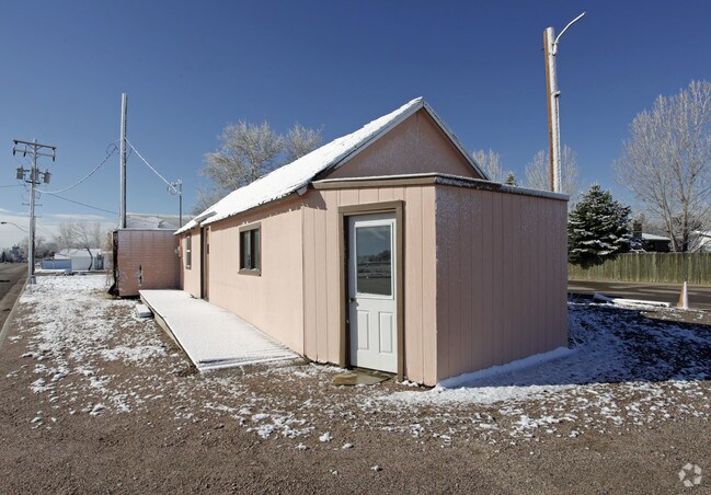


Property Detail
729 Us Highway 85
R8952600
PT NW4SW4 12-7-66 BEG AT INTERSECTION W SIDE OF UPRR AND 1/2 SEC LN RUNNING E/W OF SEC W 44 S ALNG E OF HWY 58 E TO W SIDE UPPR NWEST ALONG UPPR TO POB ALSO PT LYING S&W OF UPPR AND N&S OF SEC LN AND N&E OF 1/2 SEC TO POB ALSO COMM NW COR S40D42E 176
Commercialnec
WELD
B and X Area of moderate flood hazard, usually the area between the limits of the 100-year and 500-year floods.
Colorado
2024
0.24 AC
2025
Greeley
002300
Denver
634 SF
Greeley, CO
NEARBY LISTINGS FOR SALE OR LEASE
DEMOGRAPHICS near 729 Us Highway 85
1 mile
3 mile
5 mile
2025 Total Population
2,572
3,337
11,202
2030 Population
2,862
3,680
12,201
Pop Growth 2025-2030
+ 11.28%
+ 10.28%
+ 8.92%
Average Age
38
39
39
2025 Total Households
948
1,221
4,103
HH Growth 2025-2030
+ 11.60%
+ 10.65%
+ 9.21%
Median Household Inc
$92,137
$92,936
$102,800
Avg Household Size
2.70
2.70
2.70
2025 Avg HH Vehicles
2.00
3.00
3.00
Median Home Value
$377,300
$412,416
$477,992
Median Year Built
1981
1979
1982
Nearby Places
Map Layers
Map Styles
 Street
 Aerial
Transit
 Traffic
 Biking
Places
Listings with unknown addresses are not visible on the map
- Restaurants
- Banks
- Shops
- Fitness
- Groceries
Nearby Properties
Address
Land Use
TOTAL SIZE
Lot Size
Zoning
Address
Land Use
TOTAL SIZE
Lot Size
Zoning
143.86 AC
Address
Land Use
TOTAL SIZE
Lot Size
Zoning
3,600 SF
8.92 AC
Address
Land Use
TOTAL SIZE
Lot Size
Zoning
47,800 SF
9.76 AC
Address
Land Use
TOTAL SIZE
Lot Size
Zoning
2,788 SF
84.22 AC
Address
Land Use
TOTAL SIZE
Lot Size
Zoning
21,960 SF
9.98 AC
Address
Land Use
TOTAL SIZE
Lot Size
Zoning
6,082 SF
74 AC
Address
Land Use
TOTAL SIZE
Lot Size
Zoning
19,597 SF
13.43 AC
Address
Land Use
TOTAL SIZE
Lot Size
Zoning
45,000 SF
9.76 AC
Address
Land Use
TOTAL SIZE
Lot Size
Zoning
9,080 SF
1.11 AC
Address
Land Use
TOTAL SIZE
Lot Size
Zoning
8,954 SF
3 AC
Address
Land Use
TOTAL SIZE
Lot Size
Zoning
16,608 SF
1.40 AC
Address
Land Use
TOTAL SIZE
Lot Size
Zoning
11,843 SF
5.75 AC
Address
Land Use
TOTAL SIZE
Lot Size
Zoning
11,128 SF
2.56 AC
Address
Land Use
TOTAL SIZE
Lot Size
Zoning
10,972 SF
2.20 AC
Address
Land Use
TOTAL SIZE
Lot Size
Zoning
4,000 SF
0.42 AC
Address
Land Use
TOTAL SIZE
Lot Size
Zoning
29,712 SF
Address
Land Use
TOTAL SIZE
Lot Size
Zoning
11,250 SF
1.40 AC
Address
Land Use
TOTAL SIZE
Lot Size
Zoning
11,250 SF
4.75 AC
Address
Land Use
TOTAL SIZE
Lot Size
Zoning
7.60 AC
Address
Land Use
TOTAL SIZE
Lot Size
Zoning
20,478 SF
2.20 AC
Address
Land Use
TOTAL SIZE
Lot Size
Zoning
16,541 SF
6.01 AC
Address
Land Use
TOTAL SIZE
Lot Size
Zoning
10,269 SF
0.72 AC
Address
Land Use
TOTAL SIZE
Lot Size
Zoning
3,291 SF
0.32 AC
Address
Land Use
TOTAL SIZE
Lot Size
Zoning
6,048 SF
0.59 AC
Address
Land Use
TOTAL SIZE
Lot Size
Zoning
15,496 SF
19.80 AC
Address
Land Use
TOTAL SIZE
Lot Size
Zoning
13,660 SF
3.16 AC
Address
Land Use
TOTAL SIZE
Lot Size
Zoning
5,899 SF
0.84 AC
Address
Land Use
TOTAL SIZE
Lot Size
Zoning
23,560 SF
3.01 AC
Address
Land Use
TOTAL SIZE
Lot Size
Zoning
7,260 SF
0.83 AC
Address
Land Use
TOTAL SIZE
Lot Size
Zoning
220,840 SF
26.20 AC
The World's #1 Commercial Real Estate Marketplace
Connect with us
© 2026 CoStar Group
The information above has been obtained from sources believed reliable. While we do not doubt its accuracy we have not verified it and make no guarantee, warranty or representation about it. It is your responsibility to independently confirm its accuracy and completeness. Any projections, opinions, assumptions, or estimates used are for example only and do not represent the current or future performance of the property. The value of this transaction to you depends on tax and other factors which should be evaluated by your tax, financial, and legal advisors. You and your advisors should conduct a careful, independent investigation of the property to determine to your satisfaction the suitability of the property for your needs.