Property Record
729 W Main St, Pickens, SC 29671
NEARBY LISTINGS FOR SALE OR LEASE
Property Detail
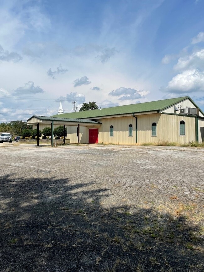
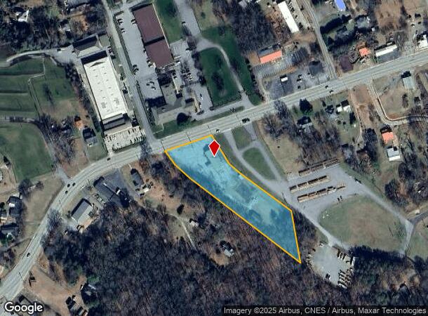
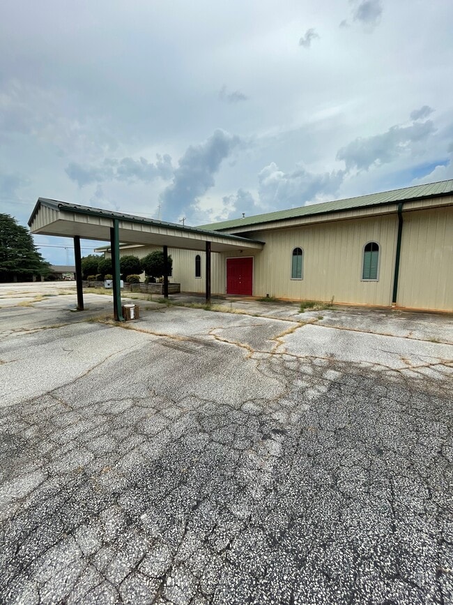
729 W Main St
4181-14-42-7821
Survey For Davis O Holland
Restaurantdrivein
S/SIDE W MAIN ST
X
Pickens
45077C0165E
South Carolina
2025
2.56 AC
2024
Pickens County
010404
Greenville/Spartanburg
4,080 SF
Greenville-Anderson-Mauldin, SC
DEMOGRAPHICS near 729 W Main St
1 Mile
3 Mile
5 Mile
2024 Total Population
2,755
10,173
20,384
2029 Population
2,884
10,650
21,309
Pop Growth 2024-2029
+ 4.68%
+ 4.69%
+ 4.54%
Average Age
41
42
42
2024 Total Households
1,102
3,981
8,020
HH Growth 2024-2029
+ 4.81%
+ 4.80%
+ 4.63%
Median Household Inc
$47,647
$47,384
$44,896
Avg Household Size
2.30
2.40
2.50
2024 Avg HH Vehicles
2.00
2.00
2.00
Median Home Value
$158,362
$165,114
$160,967
Median Year Built
1976
1980
1985
Nearby Places
Map Layers
Map Styles
 Street
 Aerial
- Restaurants
- Banks
- Shops
- Fitness
- Groceries
PUBLIC TRANSPORTATION
AIRPORT
Greenville Spartanburg International
DRIVE
WALK
Distance
Greenville Spartanburg International
57 min
34.1 mi
Freight Ports
North Charleston Terminal
DRIVE
WALK
Distance
North Charleston Terminal
261 min
222.6 mi
SALE & LEASE HISTORY
LISTING DATE
SALE/LEASE

Oct 02, 2023
For Sale
Nearby Properties
Address
Land Use
TOTAL SIZE
Lot Size
Zoning
Address
Land Use
TOTAL SIZE
Lot Size
Zoning
56,599 SF
8.02 AC
RM16
Address
Land Use
TOTAL SIZE
Lot Size
Zoning
13,376 SF
12.36 AC
Address
Land Use
TOTAL SIZE
Lot Size
Zoning
23,952 SF
6.20 AC
Address
Land Use
TOTAL SIZE
Lot Size
Zoning
29,595 SF
2.94 AC
R12
Address
Land Use
TOTAL SIZE
Lot Size
Zoning
5,356 SF
17.33 AC
Address
Land Use
TOTAL SIZE
Lot Size
Zoning
138.86 AC
GBD
Address
Land Use
TOTAL SIZE
Lot Size
Zoning
12,466 SF
2.32 AC
R12
Address
Land Use
TOTAL SIZE
Lot Size
Zoning
5,645 SF
0.67 AC
Address
Land Use
TOTAL SIZE
Lot Size
Zoning
6,070 SF
1.71 AC
CBD
Address
Land Use
TOTAL SIZE
Lot Size
Zoning
19,852 SF
47.45 AC
GBD
Address
Land Use
TOTAL SIZE
Lot Size
Zoning
5,250 SF
1.35 AC
GBD
Address
Land Use
TOTAL SIZE
Lot Size
Zoning
5,468 SF
0.75 AC
CBD
Address
Land Use
TOTAL SIZE
Lot Size
Zoning
4,133 SF
5.15 AC
R12
Address
Land Use
TOTAL SIZE
Lot Size
Zoning
91,940 SF
15.07 AC
GBD
Address
Land Use
TOTAL SIZE
Lot Size
Zoning
1,056 SF
34.54 AC
R12
Address
Land Use
TOTAL SIZE
Lot Size
Zoning
3,850 SF
12.40 AC
GBD
Address
Land Use
TOTAL SIZE
Lot Size
Zoning
2,766 SF
0.78 AC
CBD
Address
Land Use
TOTAL SIZE
Lot Size
Zoning
1,296 SF
11.05 AC
Address
Land Use
TOTAL SIZE
Lot Size
Zoning
5,400 SF
2.20 AC
GBD
Address
Land Use
TOTAL SIZE
Lot Size
Zoning
2,997 SF
1.50 AC
GBD
Address
Land Use
TOTAL SIZE
Lot Size
Zoning
4,140 SF
0.06 AC
CBD
Address
Land Use
TOTAL SIZE
Lot Size
Zoning
32,181 SF
2.90 AC
GBD
Address
Land Use
TOTAL SIZE
Lot Size
Zoning
1,716 SF
1.01 AC
GBD
Address
Land Use
TOTAL SIZE
Lot Size
Zoning
1,514 SF
0.34 AC
Address
Land Use
TOTAL SIZE
Lot Size
Zoning
51,730 SF
6.75 AC
RM16
Address
Land Use
TOTAL SIZE
Lot Size
Zoning
14,461 SF
2.48 AC
GBD
Address
Land Use
TOTAL SIZE
Lot Size
Zoning
23.39 AC
GBD
Address
Land Use
TOTAL SIZE
Lot Size
Zoning
29,565 SF
1.86 AC
GBD
Address
Land Use
TOTAL SIZE
Lot Size
Zoning
32.86 AC
The World's #1 Commercial Real Estate Marketplace
Connect with us
© 2025 CoStar Group
The information above has been obtained from sources believed reliable. While we do not doubt its accuracy we have not verified it and make no guarantee, warranty or representation about it. It is your responsibility to independently confirm its accuracy and completeness. Any projections, opinions, assumptions, or estimates used are for example only and do not represent the current or future performance of the property. The value of this transaction to you depends on tax and other factors which should be evaluated by your tax, financial, and legal advisors. You and your advisors should conduct a careful, independent investigation of the property to determine to your satisfaction the suitability of the property for your needs.