Property Record
729 W Northland Ave, Appleton, WI 54914
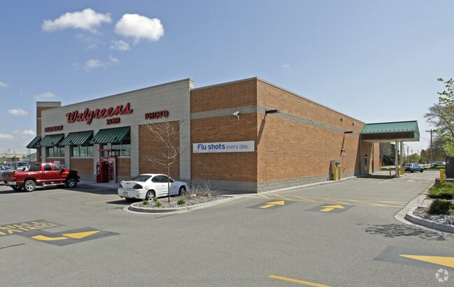

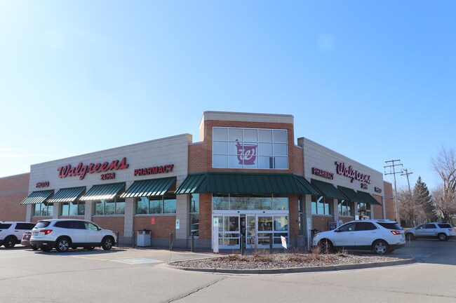
Property Detail
729 W Northland Ave
31-5-4253-00
CSM 5964 LOT 1 VOL 35 DOC 1829094 BEING LOTS 1 & 2 OF CSM 228 AND LOT 2 OF CSM 4586 AND LOTS 6,7,8,9 & 10 OF BLK 1 NORTH HEIGHTS SUBDIV
Commercialnec
Outagamie
C2
Wisconsin
B and X Area of moderate flood hazard, usually the area between the limits of the 100-year and 500-year floods.
1
2024
1.87 AC
2025
Outagamie County
011101
Green Bay
14,490 SF
Appleton, WI
NEARBY LISTINGS FOR SALE OR LEASE
DEMOGRAPHICS near 729 W Northland Ave
1 mile
3 mile
5 mile
2025 Total Population
12,591
70,542
138,323
2030 Population
12,622
71,875
141,068
Pop Growth 2025-2030
+ 0.25%
+ 1.89%
+ 1.98%
Average Age
42
40
40
2025 Total Households
5,426
29,628
57,807
HH Growth 2025-2030
+ 0.22%
+ 2.10%
+ 2.09%
Median Household Inc
$74,130
$78,779
$79,206
Avg Household Size
2.20
2.20
2.30
2025 Avg HH Vehicles
2.00
2.00
2.00
Median Home Value
$225,423
$244,787
$253,993
Median Year Built
1968
1971
1978
Nearby Places
Map Layers
Map Styles
 Street
 Aerial
Layers
 Traffic
 Biking
Places
Listings with unknown addresses are not visible on the map
- Restaurants
- Banks
- Shops
- Fitness
- Groceries
PUBLIC TRANSPORTATION
AIRPORT
Appleton International
Drive
Walk
Distance
Appleton International
16 min
9.3 mi
Green Bay/Austin Straubel International
Drive
Walk
Distance
Green Bay/Austin Straubel International
34 min
26.3 mi
Freight Ports
Port Milwaukee
Drive
Walk
Distance
Port Milwaukee
129 min
110.1 mi
SALE & LEASE HISTORY
LISTING DATE
SALE/LEASE

Jun 03, 2024
For Sale
Feb 14, 2024
For Sale
Aug 13, 2024
For Sale
Nearby Properties
Address
Land Use
TOTAL SIZE
Lot Size
Zoning
Address
Land Use
TOTAL SIZE
Lot Size
Zoning
645,392 SF
25.87 AC
Address
Land Use
TOTAL SIZE
Lot Size
Zoning
146,705 SF
Address
Land Use
TOTAL SIZE
Lot Size
Zoning
500,700 SF
47.17 AC
Address
Land Use
TOTAL SIZE
Lot Size
Zoning
154,889 SF
C2
Address
Land Use
TOTAL SIZE
Lot Size
Zoning
189,107 SF
13.37 AC
Address
Land Use
TOTAL SIZE
Lot Size
Zoning
207,455 SF
3.42 AC
PDC2
Address
Land Use
TOTAL SIZE
Lot Size
Zoning
194,573 SF
19.99 AC
Address
Land Use
TOTAL SIZE
Lot Size
Zoning
84,620 SF
92.18 AC
C2
Address
Land Use
TOTAL SIZE
Lot Size
Zoning
278,801 SF
20.94 AC
Address
Land Use
TOTAL SIZE
Lot Size
Zoning
70,136 SF
6.34 AC
C2
Address
Land Use
TOTAL SIZE
Lot Size
Zoning
191,466 SF
1.21 AC
CBD
Address
Land Use
TOTAL SIZE
Lot Size
Zoning
2,032 SF
18.48 AC
R3
Address
Land Use
TOTAL SIZE
Lot Size
Zoning
65,818 SF
8.01 AC
C2
Address
Land Use
TOTAL SIZE
Lot Size
Zoning
53,660 SF
6.59 AC
M1
Address
Land Use
TOTAL SIZE
Lot Size
Zoning
249,444 SF
18.81 AC
Address
Land Use
TOTAL SIZE
Lot Size
Zoning
29,742 SF
5.95 AC
R3
Address
Land Use
TOTAL SIZE
Lot Size
Zoning
6.66 AC
Address
Land Use
TOTAL SIZE
Lot Size
Zoning
15,560 SF
15.24 AC
Address
Land Use
TOTAL SIZE
Lot Size
Zoning
53,321 SF
2.51 AC
CBD
Address
Land Use
TOTAL SIZE
Lot Size
Zoning
44,164 SF
0.62 AC
CBD
Address
Land Use
TOTAL SIZE
Lot Size
Zoning
17.43 AC
M2
Address
Land Use
TOTAL SIZE
Lot Size
Zoning
166,336 SF
8.94 AC
Address
Land Use
TOTAL SIZE
Lot Size
Zoning
25.59 AC
Address
Land Use
TOTAL SIZE
Lot Size
Zoning
66,504 SF
5.25 AC
C2
Address
Land Use
TOTAL SIZE
Lot Size
Zoning
107,202 SF
39.98 AC
C2
Address
Land Use
TOTAL SIZE
Lot Size
Zoning
23,134 SF
0.08 AC
Address
Land Use
TOTAL SIZE
Lot Size
Zoning
38,186 SF
2.83 AC
Address
Land Use
TOTAL SIZE
Lot Size
Zoning
97,355 SF
7.99 AC
Address
Land Use
TOTAL SIZE
Lot Size
Zoning
59,272 SF
6.67 AC
R3
Address
Land Use
TOTAL SIZE
Lot Size
Zoning
13,994 SF
8.13 AC
R3
The World's #1 Commercial Real Estate Marketplace
Connect with us
© 2026 CoStar Group
The information above has been obtained from sources believed reliable. While we do not doubt its accuracy we have not verified it and make no guarantee, warranty or representation about it. It is your responsibility to independently confirm its accuracy and completeness. Any projections, opinions, assumptions, or estimates used are for example only and do not represent the current or future performance of the property. The value of this transaction to you depends on tax and other factors which should be evaluated by your tax, financial, and legal advisors. You and your advisors should conduct a careful, independent investigation of the property to determine to your satisfaction the suitability of the property for your needs.