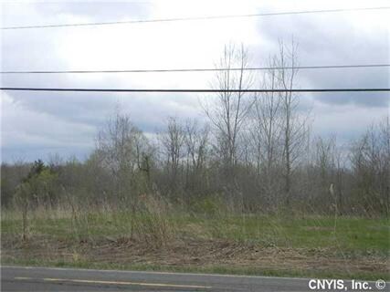
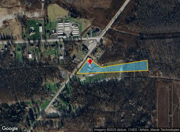
Property Record
7292 Route 298, East Syracuse, NY 13057
NEARBY LISTINGS FOR SALE OR LEASE
Property Detail
7292 Route 298
Syracuse, NY
Eldan Mdw
312289-065-000-0001-007-002-0000
ELDAN MDW SEC 9 LT 219 & 219A
Commercialnec
Onondaga
AE
New York
36067C0251F
7.002
2025
4.76 AC
2024
SE Outer Onondaga County
014500
Syracuse
DEMOGRAPHICS near 7292 Route 298
1 Mile
3 Mile
5 Mile
2024 Total Population
276
5,576
22,217
2029 Population
269
5,501
21,979
Pop Growth 2024-2029
(2.54%)
(1.35%)
(1.07%)
Average Age
48
45
44
2024 Total Households
108
2,299
9,239
HH Growth 2024-2029
(2.78%)
(1.48%)
(1.27%)
Median Household Inc
$81,034
$73,494
$77,580
Avg Household Size
2.30
2.30
2.30
2024 Avg HH Vehicles
2.00
2.00
2.00
Median Home Value
$173,076
$165,403
$172,342
Median Year Built
1960
1967
1968
Nearby Places
- Restaurants
- Banks
- Shops
- Fitness
- Groceries
PUBLIC TRANSPORTATION
AIRPORT
Syracuse Hancock International
DRIVE
WALK
Distance
Syracuse Hancock International
17 min
9.3 mi
Freight Ports
Albany, NY Port
DRIVE
WALK
Distance
Albany, NY Port
171 min
142.7 mi
Nearby Properties
Address
Land Use
TOTAL SIZE
Lot Size
Zoning
Address
Land Use
TOTAL SIZE
Lot Size
Zoning
80,845 SF
14.04 AC
06 - INDUS
Address
Land Use
TOTAL SIZE
Lot Size
Zoning
5.39 AC
06 - INDUS
Address
Land Use
TOTAL SIZE
Lot Size
Zoning
69,910 SF
16.01 AC
06 - INDUS
Address
Land Use
TOTAL SIZE
Lot Size
Zoning
49,160 SF
7.23 AC
06 - INDUS
Address
Land Use
TOTAL SIZE
Lot Size
Zoning
37.36 AC
RA
Address
Land Use
TOTAL SIZE
Lot Size
Zoning
33.18 AC
C
Address
Land Use
TOTAL SIZE
Lot Size
Zoning
70,364 SF
92.06 AC
AG
Address
Land Use
TOTAL SIZE
Lot Size
Zoning
23.21 AC
C
Address
Land Use
TOTAL SIZE
Lot Size
Zoning
54,386 SF
9.45 AC
C
Address
Land Use
TOTAL SIZE
Lot Size
Zoning
20.28 AC
C
Address
Land Use
TOTAL SIZE
Lot Size
Zoning
38.54 AC
CB
Address
Land Use
TOTAL SIZE
Lot Size
Zoning
33,446 SF
3.22 AC
C
Address
Land Use
TOTAL SIZE
Lot Size
Zoning
32,940 SF
4.78 AC
R4
Address
Land Use
TOTAL SIZE
Lot Size
Zoning
79,216 SF
27.95 AC
06 - INDUS
Address
Land Use
TOTAL SIZE
Lot Size
Zoning
21,595 SF
92.88 AC
RA
Address
Land Use
TOTAL SIZE
Lot Size
Zoning
5,256 SF
5.56 AC
Address
Land Use
TOTAL SIZE
Lot Size
Zoning
12,848 SF
1.75 AC
B
Address
Land Use
TOTAL SIZE
Lot Size
Zoning
24,997 SF
6.84 AC
06 - INDUS
Address
Land Use
TOTAL SIZE
Lot Size
Zoning
16,890 SF
2.07 AC
Address
Land Use
TOTAL SIZE
Lot Size
Zoning
6,794 SF
79.10 AC
RA
Address
Land Use
TOTAL SIZE
Lot Size
Zoning
700 SF
45.42 AC
04
Address
Land Use
TOTAL SIZE
Lot Size
Zoning
92.61 AC
06 - INDUS
Address
Land Use
TOTAL SIZE
Lot Size
Zoning
22,586 SF
34.20 AC
B
Address
Land Use
TOTAL SIZE
Lot Size
Zoning
5,507 SF
1.26 AC
A
Address
Land Use
TOTAL SIZE
Lot Size
Zoning
6,093 SF
271.33 AC
Address
Land Use
TOTAL SIZE
Lot Size
Zoning
6.71 AC
CA
Address
Land Use
TOTAL SIZE
Lot Size
Zoning
4,850 SF
1.73 AC
Address
Land Use
TOTAL SIZE
Lot Size
Zoning
1,436 SF
3.20 AC
Address
Land Use
TOTAL SIZE
Lot Size
Zoning
9,648 SF
13.23 AC
CA
Address
Land Use
TOTAL SIZE
Lot Size
Zoning
3,008 SF
131.14 AC
RA
The World's #1 Commercial Real Estate Marketplace
Connect with us
© 2025 CoStar Group
The information above has been obtained from sources believed reliable. While we do not doubt its accuracy we have not verified it and make no guarantee, warranty or representation about it. It is your responsibility to independently confirm its accuracy and completeness. Any projections, opinions, assumptions, or estimates used are for example only and do not represent the current or future performance of the property. The value of this transaction to you depends on tax and other factors which should be evaluated by your tax, financial, and legal advisors. You and your advisors should conduct a careful, independent investigation of the property to determine to your satisfaction the suitability of the property for your needs.