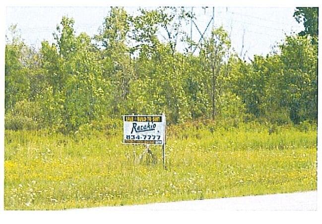
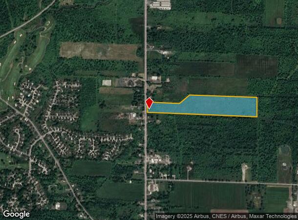
Property Record
7295 Transit Rd, East Amherst, NY 14051
NEARBY LISTINGS FOR SALE OR LEASE
Property Detail
7295 Transit Rd
Buffalo-Cheektowaga-Niagara Falls, NY
Holland Land Company S Survey
143200-029-000-0001-011-000
143OFT N C LINE LAPP RD 21.85A
Residentialacreage
Erie
AE
New York
36029C0087H
11.000
2025
22.41 AC
2024
Outlying Erie County
014701
Buffalo/Niagara Falls
1,350 SF
DEMOGRAPHICS near 7295 Transit Rd
1 Mile
3 Mile
5 Mile
2024 Total Population
1,928
27,460
83,318
2029 Population
1,930
27,452
83,326
Pop Growth 2024-2029
+ 0.10%
(0.03%)
+ 0.01%
Average Age
42
43
44
2024 Total Households
729
10,513
32,664
HH Growth 2024-2029
0.00%
(0.18%)
(0.02%)
Median Household Inc
$94,921
$118,292
$107,106
Avg Household Size
2.60
2.60
2.50
2024 Avg HH Vehicles
2.00
2.00
2.00
Median Home Value
$281,456
$345,998
$319,275
Median Year Built
1990
1987
1985
Nearby Places
- Restaurants
- Banks
- Shops
- Fitness
- Groceries
PUBLIC TRANSPORTATION
AIRPORT
Buffalo Niagara International
DRIVE
WALK
Distance
Buffalo Niagara International
14 min
8.8 mi
Niagara Falls International
DRIVE
WALK
Distance
Niagara Falls International
27 min
15.7 mi
Freight Ports
Albany, NY Port
DRIVE
WALK
Distance
Albany, NY Port
334 min
285.0 mi
SALE & LEASE HISTORY
LISTING DATE
SALE/LEASE

Sep 24, 2016
For Sale
Nearby Properties
Address
Land Use
TOTAL SIZE
Lot Size
Zoning
Address
Land Use
TOTAL SIZE
Lot Size
Zoning
5,364 SF
56.45 AC
Address
Land Use
TOTAL SIZE
Lot Size
Zoning
7,080 SF
21.40 AC
MFR-5
Address
Land Use
TOTAL SIZE
Lot Size
Zoning
4,436 SF
18.51 AC
Address
Land Use
TOTAL SIZE
Lot Size
Zoning
113,096 SF
9 AC
Address
Land Use
TOTAL SIZE
Lot Size
Zoning
403,248 SF
53.50 AC
Address
Land Use
TOTAL SIZE
Lot Size
Zoning
253,920 SF
22.83 AC
RD
Address
Land Use
TOTAL SIZE
Lot Size
Zoning
154,296 SF
7.90 AC
RD
Address
Land Use
TOTAL SIZE
Lot Size
Zoning
93,962 SF
10.07 AC
C
Address
Land Use
TOTAL SIZE
Lot Size
Zoning
12,132 SF
12.30 AC
Address
Land Use
TOTAL SIZE
Lot Size
Zoning
87,718 SF
1.26 AC
RD
Address
Land Use
TOTAL SIZE
Lot Size
Zoning
75,448 SF
8.82 AC
Address
Land Use
TOTAL SIZE
Lot Size
Zoning
9,338 SF
6.20 AC
Address
Land Use
TOTAL SIZE
Lot Size
Zoning
106,676 SF
8.90 AC
RD
Address
Land Use
TOTAL SIZE
Lot Size
Zoning
131,200 SF
16.90 AC
Address
Land Use
TOTAL SIZE
Lot Size
Zoning
131,128 SF
15.48 AC
RD
Address
Land Use
TOTAL SIZE
Lot Size
Zoning
92,368 SF
0.75 AC
RD
Address
Land Use
TOTAL SIZE
Lot Size
Zoning
86,640 SF
10.30 AC
RD
Address
Land Use
TOTAL SIZE
Lot Size
Zoning
94,352 SF
16.19 AC
Address
Land Use
TOTAL SIZE
Lot Size
Zoning
91,035 SF
20.40 AC
Address
Land Use
TOTAL SIZE
Lot Size
Zoning
44,085 SF
7.34 AC
RD
Address
Land Use
TOTAL SIZE
Lot Size
Zoning
33,704 SF
150.01 AC
Address
Land Use
TOTAL SIZE
Lot Size
Zoning
33,236 SF
3.44 AC
RD
Address
Land Use
TOTAL SIZE
Lot Size
Zoning
52,754 SF
21.83 AC
Address
Land Use
TOTAL SIZE
Lot Size
Zoning
34,839 SF
2.79 AC
Address
Land Use
TOTAL SIZE
Lot Size
Zoning
101,742 SF
11.20 AC
SA
Address
Land Use
TOTAL SIZE
Lot Size
Zoning
25,866 SF
8.18 AC
Address
Land Use
TOTAL SIZE
Lot Size
Zoning
37,183 SF
62.32 AC
RC
Address
Land Use
TOTAL SIZE
Lot Size
Zoning
38,032 SF
7.90 AC
Address
Land Use
TOTAL SIZE
Lot Size
Zoning
8,453 SF
2.46 AC
MFR-4A
Address
Land Use
TOTAL SIZE
Lot Size
Zoning
31,460 SF
3.91 AC
The World's #1 Commercial Real Estate Marketplace
Connect with us
© 2025 CoStar Group
The information above has been obtained from sources believed reliable. While we do not doubt its accuracy we have not verified it and make no guarantee, warranty or representation about it. It is your responsibility to independently confirm its accuracy and completeness. Any projections, opinions, assumptions, or estimates used are for example only and do not represent the current or future performance of the property. The value of this transaction to you depends on tax and other factors which should be evaluated by your tax, financial, and legal advisors. You and your advisors should conduct a careful, independent investigation of the property to determine to your satisfaction the suitability of the property for your needs.