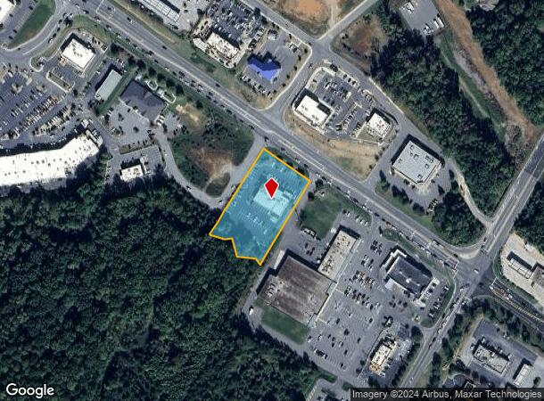
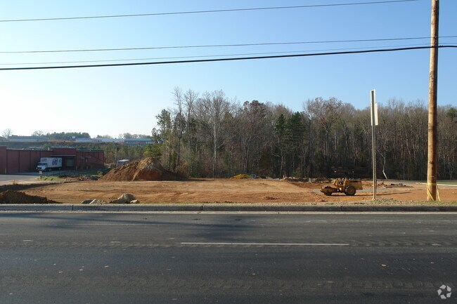
Property Record
7296 Nc 73 Hwy, Denver, NC 28037


NEARBY LISTINGS FOR SALE OR LEASE
-
-
View all Denver listings for sale on LoopNet.com
Property Detail
7296 Nc 73 Hwy
Charlotte
Cottonwood Village
Charlotte-Concord-Gastonia, NC-SC
#1 LT COTTONWOOD VILLAGE
86198
Lincoln
Restaurantbuilding
North Carolina
2025
1
2025
1.67 AC
0711021010
Lincoln County
7,891 SF
DEMOGRAPHICS near 7296 Nc 73 Hwy
1 Mile
3 Mile
5 Mile
2024 Total Population
2,506
16,598
33,678
2029 Population
2,965
19,600
39,117
Pop Growth 2024-2029
+ 18.32%
+ 18.09%
+ 16.15%
Average Age
42
45
44
2024 Total Households
985
6,792
13,363
HH Growth 2024-2029
+ 18.58%
+ 18.33%
+ 16.43%
Median Household Inc
$105,365
$101,591
$103,286
Avg Household Size
2.50
2.40
2.50
2024 Avg HH Vehicles
2.00
2.00
2.00
Median Home Value
$337,662
$380,419
$410,814
Median Year Built
2005
2002
2002
Nearby Places
Map Layers
Map Styles
 Street
 Aerial
- Restaurants
- Banks
- Shops
- Fitness
- Groceries
PUBLIC TRANSPORTATION
AIRPORT
Charlotte/Douglas International
DRIVE
WALK
Distance
Charlotte/Douglas International
38 min
20.5 mi
Concord-Padgett Regional
DRIVE
WALK
Distance
Concord-Padgett Regional
36 min
25.8 mi
Nearby Properties
Address
Land Use
TOTAL SIZE
Lot Size
Zoning
Address
Land Use
TOTAL SIZE
Lot Size
Zoning
897,320 SF
109.51 AC
I-G
Address
Land Use
TOTAL SIZE
Lot Size
Zoning
23,112 SF
11.70 AC
ELDD PD-MU
Address
Land Use
TOTAL SIZE
Lot Size
Zoning
22,383 SF
6.61 AC
ELDD PD-R
Address
Land Use
TOTAL SIZE
Lot Size
Zoning
56,780 SF
30.55 AC
B-G
Address
Land Use
TOTAL SIZE
Lot Size
Zoning
44,424 SF
36.31 AC
ELDD PD-I
Address
Land Use
TOTAL SIZE
Lot Size
Zoning
25,314 SF
18.77 AC
ELDD R-S
Address
Land Use
TOTAL SIZE
Lot Size
Zoning
22,608 SF
13.14 AC
ELDD R-S C
Address
Land Use
TOTAL SIZE
Lot Size
Zoning
100,470 SF
68.97 AC
ELDD R-SF
Address
Land Use
TOTAL SIZE
Lot Size
Zoning
24,039 SF
4 AC
ELDD PD-R
Address
Land Use
TOTAL SIZE
Lot Size
Zoning
202,357 SF
41.09 AC
ELDD B-G/B
Address
Land Use
TOTAL SIZE
Lot Size
Zoning
201,670 SF
20.06 AC
I-G
Address
Land Use
TOTAL SIZE
Lot Size
Zoning
52,732 SF
17.01 AC
ELDD R-SF
Address
Land Use
TOTAL SIZE
Lot Size
Zoning
69,310 SF
8.69 AC
ELDD PD-MU
Address
Land Use
TOTAL SIZE
Lot Size
Zoning
91,753 SF
19.94 AC
R-T
Address
Land Use
TOTAL SIZE
Lot Size
Zoning
62,569 SF
12.02 AC
ELDD R-T &
Address
Land Use
TOTAL SIZE
Lot Size
Zoning
37,782 SF
3.34 AC
B-G CU
Address
Land Use
TOTAL SIZE
Lot Size
Zoning
3,843 SF
14.97 AC
PD-R
Address
Land Use
TOTAL SIZE
Lot Size
Zoning
142,897 SF
20.44 AC
ELDD B-G C
Address
Land Use
TOTAL SIZE
Lot Size
Zoning
38,119 SF
9.31 AC
ELDD PD-C
Address
Land Use
TOTAL SIZE
Lot Size
Zoning
4,506 SF
38.05 AC
I-G & R-T
Address
Land Use
TOTAL SIZE
Lot Size
Zoning
7,800 SF
4.49 AC
ELDD B-G C
Address
Land Use
TOTAL SIZE
Lot Size
Zoning
115,200 SF
20.31 AC
I-G
Address
Land Use
TOTAL SIZE
Lot Size
Zoning
38,657 SF
3.57 AC
ELDD B-G C
Address
Land Use
TOTAL SIZE
Lot Size
Zoning
637.85 AC
R-T & PD-I
Address
Land Use
TOTAL SIZE
Lot Size
Zoning
55,084 SF
19.93 AC
R-SF
Address
Land Use
TOTAL SIZE
Lot Size
Zoning
9,000 SF
7.35 AC
ELDD I-G
Address
Land Use
TOTAL SIZE
Lot Size
Zoning
120,500 SF
12.50 AC
ELDD I-G
Address
Land Use
TOTAL SIZE
Lot Size
Zoning
26,132 SF
1.79 AC
ELDD B-G
Address
Land Use
TOTAL SIZE
Lot Size
Zoning
17,443 SF
19.66 AC
B-G
Address
Land Use
TOTAL SIZE
Lot Size
Zoning
49,788 SF
5.29 AC
ELDD B-G
The World's #1 Commercial Real Estate Marketplace
Connect with us
© 2026 CoStar Group
The information above has been obtained from sources believed reliable. While we do not doubt its accuracy we have not verified it and make no guarantee, warranty or representation about it. It is your responsibility to independently confirm its accuracy and completeness. Any projections, opinions, assumptions, or estimates used are for example only and do not represent the current or future performance of the property. The value of this transaction to you depends on tax and other factors which should be evaluated by your tax, financial, and legal advisors. You and your advisors should conduct a careful, independent investigation of the property to determine to your satisfaction the suitability of the property for your needs.