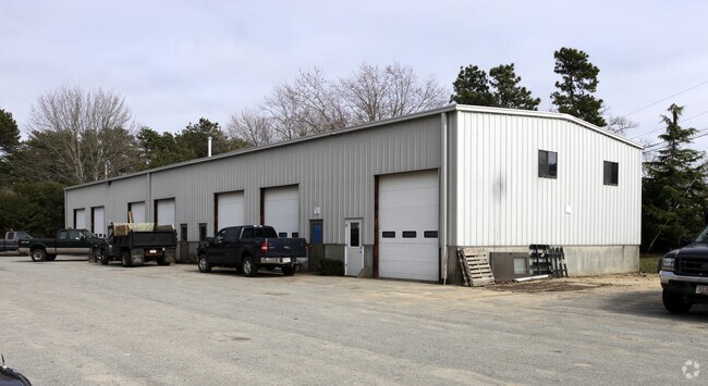
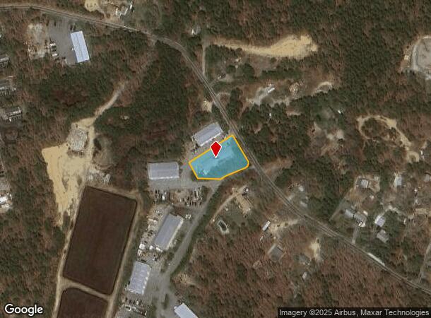
Property Record
73 Main St, Harwich, MA 02645

NEARBY LISTINGS FOR SALE OR LEASE
Property Detail
73 Main St
Commercialbuilding
Barnstable
X
Massachusetts
25001C0584J
0.57 AC
2025
Cape Cod
2025
Other Market Areas
011002
Barnstable Town, MA
5,720 SF
HARW-000055-000000-G000001-000002
DEMOGRAPHICS near 73 Main St
1 mile
3 mile
5 mile
2024 Total Population
1,323
19,384
47,094
2029 Population
1,349
20,113
48,997
Pop Growth 2024-2029
+ 1.97%
+ 3.76%
+ 4.04%
Average Age
49
51
52
2024 Total Households
544
9,256
22,451
HH Growth 2024-2029
+ 1.65%
+ 3.72%
+ 3.97%
Median Household Inc
$76,370
$71,170
$78,584
Avg Household Size
2.20
2.00
2.00
2024 Avg HH Vehicles
2.00
2.00
2.00
Median Home Value
$461,153
$460,504
$490,973
Median Year Built
1980
1972
1973
Nearby Places
Map Layers
Map Styles
 Street
 Aerial
Transit
 Traffic
 Biking
Places
Listings with unknown addresses are not visible on the map
- Restaurants
- Banks
- Shops
- Fitness
- Groceries
PUBLIC TRANSPORTATION
COMMUTER RAIL
Drive
Walk
Distance
19 min
9.6 mi
Freight Ports
Port of New Bedford Harbor
Drive
Walk
Distance
Port of New Bedford Harbor
81 min
57.5 mi
Nearby Properties
Address
Land Use
TOTAL SIZE
Lot Size
Zoning
Address
Land Use
TOTAL SIZE
Lot Size
Zoning
13.34 AC
E
Address
Land Use
TOTAL SIZE
Lot Size
Zoning
138,804 SF
15.94 AC
Address
Land Use
TOTAL SIZE
Lot Size
Zoning
12.93 AC
R
Address
Land Use
TOTAL SIZE
Lot Size
Zoning
3.42 AC
Address
Land Use
TOTAL SIZE
Lot Size
Zoning
34.40 AC
Address
Land Use
TOTAL SIZE
Lot Size
Zoning
Address
Land Use
TOTAL SIZE
Lot Size
Zoning
14,844 SF
0.50 AC
Address
Land Use
TOTAL SIZE
Lot Size
Zoning
4.88 AC
E
Address
Land Use
TOTAL SIZE
Lot Size
Zoning
59,054 SF
9.53 AC
R
Address
Land Use
TOTAL SIZE
Lot Size
Zoning
6,276 SF
0.80 AC
R
Address
Land Use
TOTAL SIZE
Lot Size
Zoning
Address
Land Use
TOTAL SIZE
Lot Size
Zoning
0.80 AC
R
Address
Land Use
TOTAL SIZE
Lot Size
Zoning
9.77 AC
Address
Land Use
TOTAL SIZE
Lot Size
Zoning
6,251 SF
1.03 AC
R
Address
Land Use
TOTAL SIZE
Lot Size
Zoning
5,649 SF
0.50 AC
R
Address
Land Use
TOTAL SIZE
Lot Size
Zoning
14.54 AC
Address
Land Use
TOTAL SIZE
Lot Size
Zoning
45.75 AC
R
Address
Land Use
TOTAL SIZE
Lot Size
Zoning
4,958 SF
0.55 AC
R
Address
Land Use
TOTAL SIZE
Lot Size
Zoning
5,700 SF
0.46 AC
R
Address
Land Use
TOTAL SIZE
Lot Size
Zoning
38,518 SF
5.09 AC
Address
Land Use
TOTAL SIZE
Lot Size
Zoning
4,583 SF
0.48 AC
R
Address
Land Use
TOTAL SIZE
Lot Size
Zoning
5,257 SF
0.39 AC
R
Address
Land Use
TOTAL SIZE
Lot Size
Zoning
62,423 SF
13.98 AC
Address
Land Use
TOTAL SIZE
Lot Size
Zoning
0.66 AC
R
Address
Land Use
TOTAL SIZE
Lot Size
Zoning
5,734 SF
1.01 AC
R
Address
Land Use
TOTAL SIZE
Lot Size
Zoning
3.17 AC
R
Address
Land Use
TOTAL SIZE
Lot Size
Zoning
0.51 AC
R
Address
Land Use
TOTAL SIZE
Lot Size
Zoning
18.49 AC
Address
Land Use
TOTAL SIZE
Lot Size
Zoning
5,545 SF
0.77 AC
R
Address
Land Use
TOTAL SIZE
Lot Size
Zoning
9,056 SF
2.05 AC
The World's #1 Commercial Real Estate Marketplace
Connect with us
© 2026 CoStar Group
The information above has been obtained from sources believed reliable. While we do not doubt its accuracy we have not verified it and make no guarantee, warranty or representation about it. It is your responsibility to independently confirm its accuracy and completeness. Any projections, opinions, assumptions, or estimates used are for example only and do not represent the current or future performance of the property. The value of this transaction to you depends on tax and other factors which should be evaluated by your tax, financial, and legal advisors. You and your advisors should conduct a careful, independent investigation of the property to determine to your satisfaction the suitability of the property for your needs.