Property Record
73 Marsh Rd, Groton, CT 06340
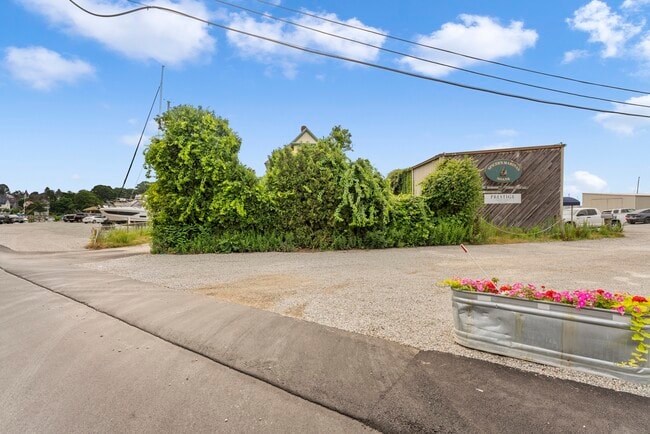
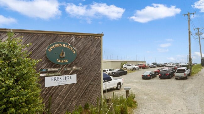
Property Detail
73 Marsh Rd
GROT-002607-000879-005233
NEW LONDON
Marinefacility
Connecticut
WC
0.55 AC
VE and V1-30 Coastal areas with a 1% or greater chance of flooding and an additional hazard associated with storm waves. These areas have a 26% chance of flooding over the life of a 30-year mortgage.
SE New London
2025
Hartford
2025
Norwich-New London-Willimantic, CT
702900
NEARBY LISTINGS FOR SALE OR LEASE
-
-
View all Groton listings for lease on LoopNet.com
DEMOGRAPHICS near 73 Marsh Rd
1 mile
3 mile
5 mile
2025 Total Population
2,059
13,092
38,242
2030 Population
2,145
13,461
39,085
Pop Growth 2025-2030
+ 4.18%
+ 2.82%
+ 2.20%
Average Age
52
48
45
2025 Total Households
996
5,945
17,570
HH Growth 2025-2030
+ 4.22%
+ 2.99%
+ 2.27%
Median Household Inc
$119,090
$114,239
$90,579
Avg Household Size
2.00
2.10
2.10
2025 Avg HH Vehicles
2.00
2.00
2.00
Median Home Value
$685,926
$541,524
$404,858
Median Year Built
1964
1965
1971
Nearby Places
Map Layers
Map Styles
 Street
 Aerial
Transit
 Traffic
 Biking
Places
Listings with unknown addresses are not visible on the map
- Restaurants
- Banks
- Shops
- Fitness
- Groceries
SALE & LEASE HISTORY
LISTING DATE
SALE/LEASE

Aug 22, 2024
For Lease
Nearby Properties
Address
Land Use
TOTAL SIZE
Lot Size
Zoning
Address
Land Use
TOTAL SIZE
Lot Size
Zoning
10,521 SF
441.93 AC
IG
Address
Land Use
TOTAL SIZE
Lot Size
Zoning
404.81 AC
GC
Address
Land Use
TOTAL SIZE
Lot Size
Zoning
276.72 AC
GC
Address
Land Use
TOTAL SIZE
Lot Size
Zoning
8,820 SF
66.22 AC
R-12
Address
Land Use
TOTAL SIZE
Lot Size
Zoning
268,573 SF
74.66 AC
RS-20
Address
Land Use
TOTAL SIZE
Lot Size
Zoning
162,521 SF
44.19 AC
RS-20
Address
Land Use
TOTAL SIZE
Lot Size
Zoning
74,433 SF
47.37 AC
RS-20
Address
Land Use
TOTAL SIZE
Lot Size
Zoning
33,404 SF
10.15 AC
MVC
Address
Land Use
TOTAL SIZE
Lot Size
Zoning
125,755 SF
14.63 AC
MVC
Address
Land Use
TOTAL SIZE
Lot Size
Zoning
520 SF
36.40 AC
RS-20
Address
Land Use
TOTAL SIZE
Lot Size
Zoning
37,434 SF
10.75 AC
MVC
Address
Land Use
TOTAL SIZE
Lot Size
Zoning
59,024 SF
3.24 AC
RS-12
Address
Land Use
TOTAL SIZE
Lot Size
Zoning
39,386 SF
28.74 AC
RS-20
Address
Land Use
TOTAL SIZE
Lot Size
Zoning
10,056 SF
28.70 AC
R-12
Address
Land Use
TOTAL SIZE
Lot Size
Zoning
26,732 SF
12.44 AC
IM
Address
Land Use
TOTAL SIZE
Lot Size
Zoning
25.88 AC
RR-80
Address
Land Use
TOTAL SIZE
Lot Size
Zoning
46,652 SF
12.23 AC
RC-120
Address
Land Use
TOTAL SIZE
Lot Size
Zoning
0.77 AC
DB-5
Address
Land Use
TOTAL SIZE
Lot Size
Zoning
35,520 SF
1.61 AC
MDD
Address
Land Use
TOTAL SIZE
Lot Size
Zoning
5,200 SF
7.12 AC
R-20
Address
Land Use
TOTAL SIZE
Lot Size
Zoning
3,072 SF
4.79 AC
WC
Address
Land Use
TOTAL SIZE
Lot Size
Zoning
20,992 SF
5.93 AC
RS-20
Address
Land Use
TOTAL SIZE
Lot Size
Zoning
112,670 SF
10.24 AC
MVC
Address
Land Use
TOTAL SIZE
Lot Size
Zoning
60,503 SF
R-40
Address
Land Use
TOTAL SIZE
Lot Size
Zoning
22,500 SF
R-40
Address
Land Use
TOTAL SIZE
Lot Size
Zoning
728 SF
2.67 AC
WC
Address
Land Use
TOTAL SIZE
Lot Size
Zoning
36,369 SF
MDD
Address
Land Use
TOTAL SIZE
Lot Size
Zoning
Address
Land Use
TOTAL SIZE
Lot Size
Zoning
16,200 SF
2 AC
MVC
Address
Land Use
TOTAL SIZE
Lot Size
Zoning
38,661 SF
9.33 AC
RS-12
The World's #1 Commercial Real Estate Marketplace
Connect with us
© 2026 CoStar Group
The information above has been obtained from sources believed reliable. While we do not doubt its accuracy we have not verified it and make no guarantee, warranty or representation about it. It is your responsibility to independently confirm its accuracy and completeness. Any projections, opinions, assumptions, or estimates used are for example only and do not represent the current or future performance of the property. The value of this transaction to you depends on tax and other factors which should be evaluated by your tax, financial, and legal advisors. You and your advisors should conduct a careful, independent investigation of the property to determine to your satisfaction the suitability of the property for your needs.