Property Record
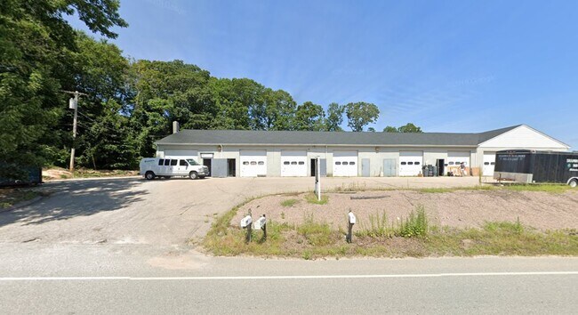
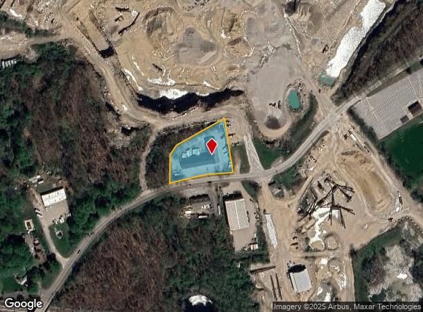
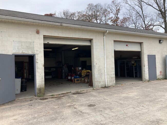
73 Old Hopkinton Rd, Westerly, RI 02891
NEARBY LISTINGS FOR SALE OR LEASE
Property Detail
73 Old Hopkinton Rd
WEST-000048-000042A
Washington
Commercialacreage
Rhode Island
X
a
44009C0143J
0.16 AC
2025
Washington County
2025
Providence
050901
Providence-Warwick, RI-MA
DEMOGRAPHICS near 73 Old Hopkinton Rd
1 Mile
3 Mile
5 Mile
2024 Total Population
4,564
22,484
37,285
2029 Population
4,446
22,110
37,296
Pop Growth 2024-2029
(2.59%)
(1.66%)
+ 0.03%
Average Age
43
44
45
2024 Total Households
1,952
9,886
16,154
HH Growth 2024-2029
(3.02%)
(1.92%)
0.00%
Median Household Inc
$87,073
$77,139
$87,460
Avg Household Size
2.20
2.20
2.20
2024 Avg HH Vehicles
2.00
2.00
2.00
Median Home Value
$352,825
$346,085
$376,552
Median Year Built
1969
1966
1971
Nearby Places
Map Layers
Map Styles
 Street
 Aerial
- Restaurants
- Banks
- Shops
- Fitness
- Groceries
PUBLIC TRANSPORTATION
COMMUTER RAIL
Westerly Amtrak Station (Northeast Regional - Amtrak)
DRIVE
WALK
Distance
Westerly Amtrak Station (Northeast Regional - Amtrak)
2 min
1.2 mi
Mystic Amtrak (Northeast Regional - Amtrak)
DRIVE
WALK
Distance
Mystic Amtrak (Northeast Regional - Amtrak)
14 min
9.3 mi
Freight Ports
Port of Davisville, RI
DRIVE
WALK
Distance
Port of Davisville, RI
52 min
36.6 mi
SALE & LEASE HISTORY
LISTING DATE
SALE/LEASE

Nov 22, 2022
For Sale
Nearby Properties
Address
Land Use
TOTAL SIZE
Lot Size
Zoning
Address
Land Use
TOTAL SIZE
Lot Size
Zoning
10.60 AC
Address
Land Use
TOTAL SIZE
Lot Size
Zoning
157,662 SF
27.62 AC
Address
Land Use
TOTAL SIZE
Lot Size
Zoning
181,967 SF
143 AC
RR-80
Address
Land Use
TOTAL SIZE
Lot Size
Zoning
154,316 SF
4.57 AC
Address
Land Use
TOTAL SIZE
Lot Size
Zoning
25.60 AC
Address
Land Use
TOTAL SIZE
Lot Size
Zoning
14.24 AC
Address
Land Use
TOTAL SIZE
Lot Size
Zoning
17,993 SF
13.03 AC
Address
Land Use
TOTAL SIZE
Lot Size
Zoning
96,882 SF
13.12 AC
Address
Land Use
TOTAL SIZE
Lot Size
Zoning
14.71 AC
Address
Land Use
TOTAL SIZE
Lot Size
Zoning
14.04 AC
Address
Land Use
TOTAL SIZE
Lot Size
Zoning
66,003 SF
44.50 AC
GBR-13
Address
Land Use
TOTAL SIZE
Lot Size
Zoning
117,852 SF
19.78 AC
Address
Land Use
TOTAL SIZE
Lot Size
Zoning
0.55 AC
Address
Land Use
TOTAL SIZE
Lot Size
Zoning
248.11 AC
Address
Land Use
TOTAL SIZE
Lot Size
Zoning
7.79 AC
Address
Land Use
TOTAL SIZE
Lot Size
Zoning
5,055 SF
24.56 AC
GBR-13
Address
Land Use
TOTAL SIZE
Lot Size
Zoning
40,943 SF
25.78 AC
Address
Land Use
TOTAL SIZE
Lot Size
Zoning
40,705 SF
1.07 AC
Address
Land Use
TOTAL SIZE
Lot Size
Zoning
64,166 SF
12 AC
HI-60
Address
Land Use
TOTAL SIZE
Lot Size
Zoning
47,737 SF
9.96 AC
Address
Land Use
TOTAL SIZE
Lot Size
Zoning
60,968 SF
8 AC
RA-15
Address
Land Use
TOTAL SIZE
Lot Size
Zoning
28,760 SF
Address
Land Use
TOTAL SIZE
Lot Size
Zoning
142.05 AC
Address
Land Use
TOTAL SIZE
Lot Size
Zoning
121,068 SF
2.53 AC
M-1
Address
Land Use
TOTAL SIZE
Lot Size
Zoning
11.40 AC
RFR8
Address
Land Use
TOTAL SIZE
Lot Size
Zoning
49,103 SF
12.11 AC
Address
Land Use
TOTAL SIZE
Lot Size
Zoning
46,362 SF
7.43 AC
Address
Land Use
TOTAL SIZE
Lot Size
Zoning
114.16 AC
OS
Address
Land Use
TOTAL SIZE
Lot Size
Zoning
3,000 SF
50.36 AC
HI-60
Address
Land Use
TOTAL SIZE
Lot Size
Zoning
15.58 AC
The World's #1 Commercial Real Estate Marketplace
Connect with us
© 2025 CoStar Group
The information above has been obtained from sources believed reliable. While we do not doubt its accuracy we have not verified it and make no guarantee, warranty or representation about it. It is your responsibility to independently confirm its accuracy and completeness. Any projections, opinions, assumptions, or estimates used are for example only and do not represent the current or future performance of the property. The value of this transaction to you depends on tax and other factors which should be evaluated by your tax, financial, and legal advisors. You and your advisors should conduct a careful, independent investigation of the property to determine to your satisfaction the suitability of the property for your needs.