Property Record
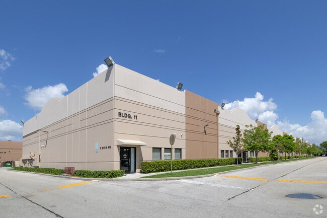
73 Sw 12Th Ave, Dania, FL 33004


This Property Is For Sale
NEARBY LISTINGS FOR SALE OR LEASE
Property Detail
73 Sw 12Th Ave
50-42-33-AA-0100
Dania Distribution Center
Transportnec
DANIA DISTRIBUTION CENTRE CONDO UNIT 110 BLDG 1 PER CDO BK/PG: 39824/1080
AE
Broward
12011C0567J
Florida
2024
0.09 AC
2025
Southeast Broward
080500
South Florida
4,100 SF
Fort Lauderdale-Pompano Beach-Deerfield Beach, FL
DEMOGRAPHICS near 73 Sw 12Th Ave
1 Mile
3 Mile
5 Mile
2024 Total Population
11,863
96,836
306,172
2029 Population
12,156
97,386
308,469
Pop Growth 2024-2029
+ 2.47%
+ 0.57%
+ 0.75%
Average Age
41
42
42
2024 Total Households
4,752
40,444
128,717
HH Growth 2024-2029
+ 2.36%
+ 0.14%
+ 0.76%
Median Household Inc
$43,062
$59,004
$61,510
Avg Household Size
2.40
2.30
2.30
2024 Avg HH Vehicles
1.00
2.00
2.00
Median Home Value
$315,821
$377,207
$362,476
Median Year Built
1973
1973
1973
Nearby Places
Map Layers
Map Styles
 Street
 Aerial
- Restaurants
- Banks
- Shops
- Fitness
- Groceries
PUBLIC TRANSPORTATION
COMMUTER RAIL
Fort Lauderdale/Hollywood International Airport (Mangonia Park - Miami Airport - Tri-Rail, Tri-County Commuter - Tri-Rail, West Palm Beach - MiamiCentral - Tri-Rail)
DRIVE
WALK
Distance
Fort Lauderdale/Hollywood International Airport (Mangonia Park - Miami Airport - Tri-Rail, Tri-County Commuter - Tri-Rail, West Palm Beach - MiamiCentral - Tri-Rail)
7 min
2.5 mi
Sheridan Street (Tri-County Commuter - South Florida Regional Transportation Authority (Tri-Rail))
DRIVE
WALK
Distance
Sheridan Street (Tri-County Commuter - South Florida Regional Transportation Authority (Tri-Rail))
9 min
2.8 mi
AIRPORT
Fort Lauderdale/Hollywood International
DRIVE
WALK
Distance
Fort Lauderdale/Hollywood International
10 min
3.6 mi
Miami International
DRIVE
WALK
Distance
Miami International
44 min
26.7 mi
Freight Ports
Port Everglades
DRIVE
WALK
Distance
Port Everglades
10 min
4.3 mi
Nearby Properties
Address
Land Use
TOTAL SIZE
Lot Size
Zoning
Address
Land Use
TOTAL SIZE
Lot Size
Zoning
4,515,106 SF
887.02 AC
AT
Address
Land Use
TOTAL SIZE
Lot Size
Zoning
3,629,204 SF
159.43 AC
AT
Address
Land Use
TOTAL SIZE
Lot Size
Zoning
2,786,552 SF
25.77 AC
HD
Address
Land Use
TOTAL SIZE
Lot Size
Zoning
964,376 SF
258.71 AC
AT
Address
Land Use
TOTAL SIZE
Lot Size
Zoning
654,212 SF
3.59 AC
Address
Land Use
TOTAL SIZE
Lot Size
Zoning
311,472 SF
136.47 AC
PEDD
Address
Land Use
TOTAL SIZE
Lot Size
Zoning
91,897 SF
175.58 AC
PEDD
Address
Land Use
TOTAL SIZE
Lot Size
Zoning
272,634 SF
32.39 AC
PMUD
Address
Land Use
TOTAL SIZE
Lot Size
Zoning
376,559 SF
14.53 AC
PD
Address
Land Use
TOTAL SIZE
Lot Size
Zoning
615,846 SF
2.06 AC
CC
Address
Land Use
TOTAL SIZE
Lot Size
Zoning
828,208 SF
44.48 AC
PMUD
Address
Land Use
TOTAL SIZE
Lot Size
Zoning
478,740 SF
1.05 AC
YC
Address
Land Use
TOTAL SIZE
Lot Size
Zoning
579,420 SF
1.68 AC
ND-3
Address
Land Use
TOTAL SIZE
Lot Size
Zoning
296,691 SF
1.86 AC
PMUD
Address
Land Use
TOTAL SIZE
Lot Size
Zoning
241,796 SF
1.64 AC
BRT-25-C
Address
Land Use
TOTAL SIZE
Lot Size
Zoning
523,233 SF
2.30 AC
ND-3
Address
Land Use
TOTAL SIZE
Lot Size
Zoning
218,137 SF
7.13 AC
RM-2
Address
Land Use
TOTAL SIZE
Lot Size
Zoning
291,551 SF
29.64 AC
C-3
Address
Land Use
TOTAL SIZE
Lot Size
Zoning
287,160 SF
16.39 AC
RM-18
Address
Land Use
TOTAL SIZE
Lot Size
Zoning
313,850 SF
0.80 AC
Address
Land Use
TOTAL SIZE
Lot Size
Zoning
247,174 SF
9.03 AC
RM-2
Address
Land Use
TOTAL SIZE
Lot Size
Zoning
524,102 SF
3.19 AC
ND-3
Address
Land Use
TOTAL SIZE
Lot Size
Zoning
552,737 SF
11.76 AC
C-4
Address
Land Use
TOTAL SIZE
Lot Size
Zoning
370,172 SF
24.52 AC
GU
Address
Land Use
TOTAL SIZE
Lot Size
Zoning
221,179 SF
25.86 AC
EDBB-MU
Address
Land Use
TOTAL SIZE
Lot Size
Zoning
289,524 SF
39.20 AC
GU
Address
Land Use
TOTAL SIZE
Lot Size
Zoning
480 SF
2.43 AC
PMUD-SL
Address
Land Use
TOTAL SIZE
Lot Size
Zoning
155,686 SF
10.35 AC
PRD-1
Address
Land Use
TOTAL SIZE
Lot Size
Zoning
151,839 SF
9.66 AC
RM-2
Address
Land Use
TOTAL SIZE
Lot Size
Zoning
257,137 SF
2.80 AC
B-2
The World's #1 Commercial Real Estate Marketplace
Connect with us
© 2025 CoStar Group
The information above has been obtained from sources believed reliable. While we do not doubt its accuracy we have not verified it and make no guarantee, warranty or representation about it. It is your responsibility to independently confirm its accuracy and completeness. Any projections, opinions, assumptions, or estimates used are for example only and do not represent the current or future performance of the property. The value of this transaction to you depends on tax and other factors which should be evaluated by your tax, financial, and legal advisors. You and your advisors should conduct a careful, independent investigation of the property to determine to your satisfaction the suitability of the property for your needs.