Property Record
73 Veterans Rd W, Santa Rosa Beach, FL 32459
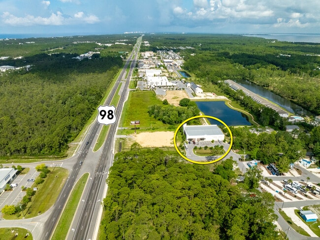
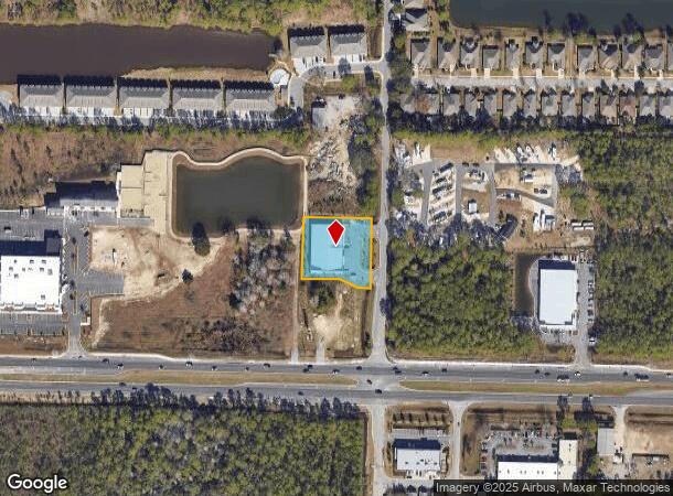
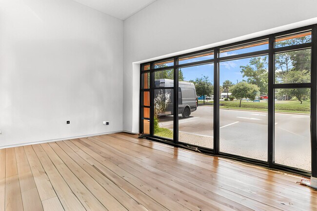
This Property Is For Sale
NEARBY LISTINGS FOR SALE OR LEASE
Property Detail
73 Veterans Rd W
Other Market Areas
Yolo-Stephens
Crestview-Fort Walton Beach-Destin, FL
LOT 1 YOLO-STEPHENS S/D PB 26-40 DESC AS: COM NE/C OF LOT 48 SANTA ROSA PLANTATION COMPANY S/D SEC 26-2S-20W PB 2-4, PROCEED ALG N LINE OF SAID LOT N 89 DEG 5107W 33.00FT TO INT OF SAID LOT & WLY ROW LINE OF VETERANS RD, SAID PT ALSO BEING POB, PROCE
26-2S-20-33230-000-0010
Walton
Warehouse
Florida
2025
1,48
2025
0.90 AC
950605
Florida Panhandle Area
14,319 SF
DEMOGRAPHICS near 73 Veterans Rd W
1 Mile
3 Mile
5 Mile
2024 Total Population
1,256
13,672
18,176
2029 Population
1,411
15,892
20,990
Pop Growth 2024-2029
+ 12.34%
+ 16.24%
+ 15.48%
Average Age
38
41
41
2024 Total Households
481
5,437
7,202
HH Growth 2024-2029
+ 11.85%
+ 15.87%
+ 15.15%
Median Household Inc
$80,769
$95,122
$97,551
Avg Household Size
2.40
2.40
2.40
2024 Avg HH Vehicles
2.00
2.00
2.00
Median Home Value
$485,506
$606,911
$596,564
Median Year Built
2008
2005
2005
Nearby Places
- Restaurants
- Banks
- Shops
- Fitness
- Groceries
PUBLIC TRANSPORTATION
AIRPORT
Eglin AFB/Destin-Ft Walton Beach
DRIVE
WALK
Distance
Eglin AFB/Destin-Ft Walton Beach
62 min
30.6 mi
Northwest Florida Beaches International
DRIVE
WALK
Distance
Northwest Florida Beaches International
52 min
35.4 mi
Freight Ports
Port of Panama City
DRIVE
WALK
Distance
Port of Panama City
51 min
33.7 mi
Nearby Properties
Address
Land Use
TOTAL SIZE
Lot Size
Zoning
Address
Land Use
TOTAL SIZE
Lot Size
Zoning
191,948 SF
45.59 AC
3310
Address
Land Use
TOTAL SIZE
Lot Size
Zoning
312,685 SF
28.42 AC
SMNBHD
Address
Land Use
TOTAL SIZE
Lot Size
Zoning
269,585 SF
14.50 AC
SMNBHD
Address
Land Use
TOTAL SIZE
Lot Size
Zoning
210,258 SF
20.45 AC
TC1
Address
Land Use
TOTAL SIZE
Lot Size
Zoning
200,408 SF
10.73 AC
VMU
Address
Land Use
TOTAL SIZE
Lot Size
Zoning
140,273 SF
30 AC
Address
Land Use
TOTAL SIZE
Lot Size
Zoning
17,317 SF
65.65 AC
GULFFR
Address
Land Use
TOTAL SIZE
Lot Size
Zoning
154,979 SF
9.92 AC
TC1
Address
Land Use
TOTAL SIZE
Lot Size
Zoning
2.27 AC
GULFFR
Address
Land Use
TOTAL SIZE
Lot Size
Zoning
0.87 AC
GULFFR
Address
Land Use
TOTAL SIZE
Lot Size
Zoning
109,317 SF
10 AC
TC1
Address
Land Use
TOTAL SIZE
Lot Size
Zoning
483 SF
4.15 AC
GULFFR
Address
Land Use
TOTAL SIZE
Lot Size
Zoning
73,257 SF
10.62 AC
HWY 98
Address
Land Use
TOTAL SIZE
Lot Size
Zoning
Address
Land Use
TOTAL SIZE
Lot Size
Zoning
83,492 SF
7.25 AC
HWY 98
Address
Land Use
TOTAL SIZE
Lot Size
Zoning
126,494 SF
7.99 AC
VMU
Address
Land Use
TOTAL SIZE
Lot Size
Zoning
114,921 SF
3.43 AC
HWY 98
Address
Land Use
TOTAL SIZE
Lot Size
Zoning
2.44 AC
GULFFR
Address
Land Use
TOTAL SIZE
Lot Size
Zoning
112,780 SF
5.73 AC
VMU
Address
Land Use
TOTAL SIZE
Lot Size
Zoning
Address
Land Use
TOTAL SIZE
Lot Size
Zoning
14,291 SF
59.59 AC
Address
Land Use
TOTAL SIZE
Lot Size
Zoning
0.78 AC
GULFFR
Address
Land Use
TOTAL SIZE
Lot Size
Zoning
2.30 AC
VMU
Address
Land Use
TOTAL SIZE
Lot Size
Zoning
54,208 SF
9.75 AC
NBHDIN
Address
Land Use
TOTAL SIZE
Lot Size
Zoning
5,494 SF
0.84 AC
GULFFR
Address
Land Use
TOTAL SIZE
Lot Size
Zoning
7,152 SF
0.91 AC
Address
Land Use
TOTAL SIZE
Lot Size
Zoning
50,793 SF
23.08 AC
3310
Address
Land Use
TOTAL SIZE
Lot Size
Zoning
4.23 AC
GULFFR
Address
Land Use
TOTAL SIZE
Lot Size
Zoning
0.72 AC
GULFFR
Address
Land Use
TOTAL SIZE
Lot Size
Zoning
9,870 SF
0.66 AC
GULFFR
The World's #1 Commercial Real Estate Marketplace
Connect with us
© 2025 CoStar Group
The information above has been obtained from sources believed reliable. While we do not doubt its accuracy we have not verified it and make no guarantee, warranty or representation about it. It is your responsibility to independently confirm its accuracy and completeness. Any projections, opinions, assumptions, or estimates used are for example only and do not represent the current or future performance of the property. The value of this transaction to you depends on tax and other factors which should be evaluated by your tax, financial, and legal advisors. You and your advisors should conduct a careful, independent investigation of the property to determine to your satisfaction the suitability of the property for your needs.