Property Record
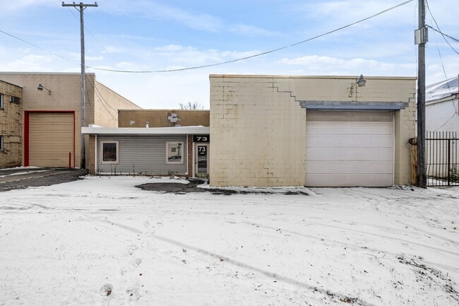
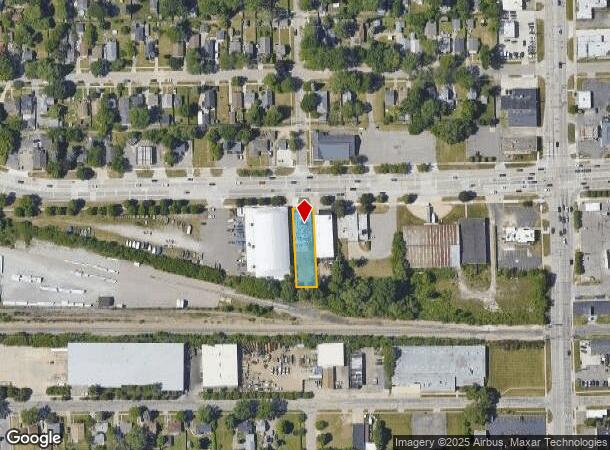
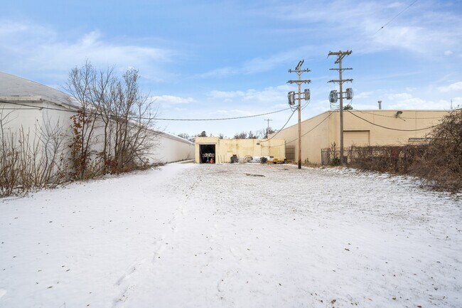
73 W Walton Blvd, Pontiac, MI 48340
This Property Is For Sale
NEARBY LISTINGS FOR SALE OR LEASE
Property Detail
73 W Walton Blvd
14-17-126-003
T3N, R10E, SEC 17 PART OF NE 1/4 OF NW 1/4 BEG AT PT DIST N 89-37-00 W 770 FT & S 00-25-15 W 60 FT FROM N 1/4 COR, TH S 01-13-00 E 223.70 FT, TH S 88-13-00 E 60 FT, TH N 01-12-20 W 225.17 FT, TH N 89-37-00 W 60 FT TO BEG 0.31 A
Manufacturinglight
Oakland
X
Michigan
26125C0366F
0.31 AC
2024
Auburn Hills, Pontiac & Rochester
2024
Detroit
141100
Detroit-Warren-Dearborn, MI
5,942 SF
DEMOGRAPHICS near 73 W Walton Blvd
1 Mile
3 Mile
5 Mile
2024 Total Population
11,570
61,699
153,607
2029 Population
11,464
61,492
153,024
Pop Growth 2024-2029
(0.92%)
(0.34%)
(0.38%)
Average Age
37
38
39
2024 Total Households
4,565
24,851
62,981
HH Growth 2024-2029
(0.92%)
(0.43%)
(0.46%)
Median Household Inc
$37,766
$46,958
$56,634
Avg Household Size
2.40
2.40
2.30
2024 Avg HH Vehicles
1.00
2.00
2.00
Median Home Value
$76,270
$128,668
$187,082
Median Year Built
1960
1964
1970
Nearby Places
- Restaurants
- Banks
- Shops
- Fitness
- Groceries
PUBLIC TRANSPORTATION
COMMUTER RAIL
DRIVE
WALK
Distance
8 min
3.4 mi
AIRPORT
Bishop International
DRIVE
WALK
Distance
Bishop International
53 min
36.1 mi
Windsor International
DRIVE
WALK
Distance
Windsor International
64 min
42.7 mi
Detroit Metro Wayne County
DRIVE
WALK
Distance
Detroit Metro Wayne County
68 min
43.5 mi
Nearby Properties
Address
Land Use
TOTAL SIZE
Lot Size
Zoning
Address
Land Use
TOTAL SIZE
Lot Size
Zoning
1,421,000 SF
170.30 AC
B2
Address
Land Use
TOTAL SIZE
Lot Size
Zoning
527,000 SF
36.03 AC
Address
Land Use
TOTAL SIZE
Lot Size
Zoning
316,358 SF
20.89 AC
P
Address
Land Use
TOTAL SIZE
Lot Size
Zoning
420,858 SF
65.07 AC
Address
Land Use
TOTAL SIZE
Lot Size
Zoning
1,771,589 SF
96.73 AC
Address
Land Use
TOTAL SIZE
Lot Size
Zoning
430,338 SF
46.09 AC
Address
Land Use
TOTAL SIZE
Lot Size
Zoning
246,150 SF
26.64 AC
TR
Address
Land Use
TOTAL SIZE
Lot Size
Zoning
247,500 SF
Address
Land Use
TOTAL SIZE
Lot Size
Zoning
430,338 SF
43.22 AC
Address
Land Use
TOTAL SIZE
Lot Size
Zoning
213,112 SF
12.17 AC
I1
Address
Land Use
TOTAL SIZE
Lot Size
Zoning
455,045 SF
23.47 AC
I1
Address
Land Use
TOTAL SIZE
Lot Size
Zoning
232,860 SF
28.30 AC
I1
Address
Land Use
TOTAL SIZE
Lot Size
Zoning
174,019 SF
9.66 AC
Address
Land Use
TOTAL SIZE
Lot Size
Zoning
186,242 SF
Address
Land Use
TOTAL SIZE
Lot Size
Zoning
136,061 SF
14.64 AC
Address
Land Use
TOTAL SIZE
Lot Size
Zoning
173,974 SF
31.37 AC
TR
Address
Land Use
TOTAL SIZE
Lot Size
Zoning
171,242 SF
11.86 AC
Address
Land Use
TOTAL SIZE
Lot Size
Zoning
148,825 SF
Address
Land Use
TOTAL SIZE
Lot Size
Zoning
101,320 SF
28.20 AC
Address
Land Use
TOTAL SIZE
Lot Size
Zoning
142,858 SF
Address
Land Use
TOTAL SIZE
Lot Size
Zoning
124,104 SF
Address
Land Use
TOTAL SIZE
Lot Size
Zoning
245,436 SF
39.08 AC
Address
Land Use
TOTAL SIZE
Lot Size
Zoning
218,870 SF
23.21 AC
Address
Land Use
TOTAL SIZE
Lot Size
Zoning
79,263 SF
22.27 AC
Address
Land Use
TOTAL SIZE
Lot Size
Zoning
137,086 SF
Address
Land Use
TOTAL SIZE
Lot Size
Zoning
174,265 SF
13.50 AC
TR
Address
Land Use
TOTAL SIZE
Lot Size
Zoning
110,521 SF
3.23 AC
B2
Address
Land Use
TOTAL SIZE
Lot Size
Zoning
125,108 SF
27.93 AC
I1
Address
Land Use
TOTAL SIZE
Lot Size
Zoning
65,432 SF
16.57 AC
Address
Land Use
TOTAL SIZE
Lot Size
Zoning
245,436 SF
29.85 AC
The World's #1 Commercial Real Estate Marketplace
Connect with us
© 2025 CoStar Group
The information above has been obtained from sources believed reliable. While we do not doubt its accuracy we have not verified it and make no guarantee, warranty or representation about it. It is your responsibility to independently confirm its accuracy and completeness. Any projections, opinions, assumptions, or estimates used are for example only and do not represent the current or future performance of the property. The value of this transaction to you depends on tax and other factors which should be evaluated by your tax, financial, and legal advisors. You and your advisors should conduct a careful, independent investigation of the property to determine to your satisfaction the suitability of the property for your needs.