Property Record
730 Clinton St, Brooklyn, NY 11231
Save to a Folder
{{folder.Name}}
{{folder.ListingIds.length}} Properties
{{folder.ListingIds.length}} Property
Create a New Folder
Current Lease Availabilities
Property Detail
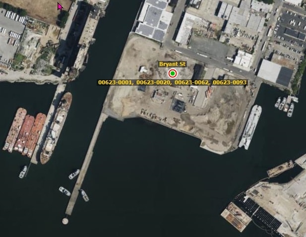
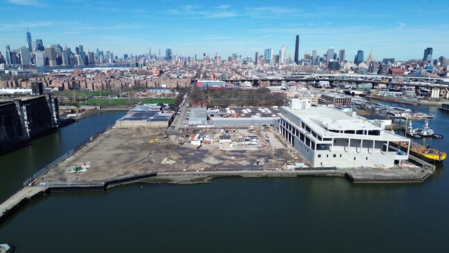
730 Clinton St
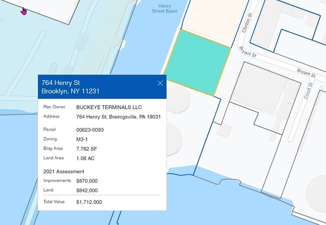
00623-0020
DOCID-2021122000810005
Commercialnec
KINGS
M3-1
New York
VE and V1-30 Coastal areas with a 1% or greater chance of flooding and an additional hazard associated with storm waves. These areas have a 26% chance of flooding over the life of a 30-year mortgage.
93
2025
6.21 AC
2026
North Brooklyn
006500
Long Island (New York)
42,222 SF
New York-Jersey City-White Plains, NY-NJ
NEARBY LISTINGS FOR SALE OR LEASE
-
-
-
No Photo
-
-
-
-
-
-
-
-
-
-
-
View all Brooklyn listings for lease on LoopNet.com
DEMOGRAPHICS near 730 Clinton St
1 mile
3 mile
5 mile
2025 Total Population
53,335
839,980
2,513,899
2030 Population
52,999
839,273
2,532,564
Pop Growth 2025-2030
(0.63%)
(0.08%)
+ 0.74%
Average Age
38
38
39
2025 Total Households
21,790
325,923
987,332
HH Growth 2025-2030
(1.09%)
+ 0.10%
+ 1.06%
Median Household Inc
$127,416
$106,819
$92,100
Avg Household Size
2.30
2.40
2.40
2025 Avg HH Vehicles
1.00
.00
.00
Median Home Value
$1,087,365
$1,044,595
$998,001
Median Year Built
1947
1948
1948
Nearby Places
Map Layers
Map Styles
 Street
 Aerial
Layers
 Traffic
 Biking
Places
Listings with unknown addresses are not visible on the map
- Restaurants
- Banks
- Shops
- Fitness
- Groceries
PUBLIC TRANSPORTATION
TRANSIT/SUBWAY
Smith-9 Streets (F - New York MTA Subway (The Subway), G - New York MTA Subway (The Subway))
Drive
Walk
Distance
Smith-9 Streets (F - New York MTA Subway (The Subway), G - New York MTA Subway (The Subway))
2 min
13 min
0.7 mi
Prospect Avenue (D,M,N,R Line) (D - New York MTA Subway (The Subway), M - New York MTA Subway (The Subway), N - New York MTA Subway (The Subway), R - New York MTA Subway (The Subway))
Drive
Walk
Distance
Prospect Avenue (D,M,N,R Line) (D - New York MTA Subway (The Subway), M - New York MTA Subway (The Subway), N - New York MTA Subway (The Subway), R - New York MTA Subway (The Subway))
3 min
20 min
1.1 mi
COMMUTER RAIL
Atlantic Terminal (Babylon Branch - Long Island Rail Road, City Terminal Zone - Long Island Rail Road, Hempstead Branch - Long Island Rail Road, West Hempstead Branch - Long Island Rail Road)
Drive
Walk
Distance
Atlantic Terminal (Babylon Branch - Long Island Rail Road, City Terminal Zone - Long Island Rail Road, Hempstead Branch - Long Island Rail Road, West Hempstead Branch - Long Island Rail Road)
9 min
2.7 mi
Nostrand Avenue Station (Far Rockaway Branch - Long Island Rail Road, Hempstead Branch - Long Island Rail Road, Long Beach Branch - Long Island Rail Road, West Hempstead Branch - Long Island Rail Road)
Drive
Walk
Distance
Nostrand Avenue Station (Far Rockaway Branch - Long Island Rail Road, Hempstead Branch - Long Island Rail Road, Long Beach Branch - Long Island Rail Road, West Hempstead Branch - Long Island Rail Road)
12 min
4.2 mi
AIRPORT
LaGuardia
Drive
Walk
Distance
LaGuardia
22 min
12.4 mi
John F Kennedy International
Drive
Walk
Distance
John F Kennedy International
29 min
15.2 mi
Newark Liberty International
Drive
Walk
Distance
Newark Liberty International
27 min
15.9 mi
Freight Ports
NY - Red Hook Container Terminal
Drive
Walk
Distance
NY - Red Hook Container Terminal
3 min
1.3 mi
Nearby Properties
Address
Land Use
TOTAL SIZE
Lot Size
Zoning
Address
Land Use
TOTAL SIZE
Lot Size
Zoning
1,104,184 SF
1.12 AC
C5-5
Address
Land Use
TOTAL SIZE
Lot Size
Zoning
1,780,030 SF
5.07 AC
BPC
Address
Land Use
TOTAL SIZE
Lot Size
Zoning
869,038 SF
1.53 AC
M1-1
Address
Land Use
TOTAL SIZE
Lot Size
Zoning
1,617,206 SF
1.23 AC
C5-5
Address
Land Use
TOTAL SIZE
Lot Size
Zoning
92,440 SF
466.23 AC
R5
Address
Land Use
TOTAL SIZE
Lot Size
Zoning
2,210,200 SF
2.58 AC
C5-5
Address
Land Use
TOTAL SIZE
Lot Size
Zoning
1,362,190 SF
C5-5
Address
Land Use
TOTAL SIZE
Lot Size
Zoning
1,440,960 SF
2.17 AC
BPC
Address
Land Use
TOTAL SIZE
Lot Size
Zoning
1,499,568 SF
1.66 AC
C5-5
Address
Land Use
TOTAL SIZE
Lot Size
Zoning
2,542,066 SF
174.49 AC
R3-2
Address
Land Use
TOTAL SIZE
Lot Size
Zoning
455,815 SF
0.21 AC
C5-5
Address
Land Use
TOTAL SIZE
Lot Size
Zoning
393.54 AC
PARK
Address
Land Use
TOTAL SIZE
Lot Size
Zoning
945,425 SF
21.70 AC
PARK
Address
Land Use
TOTAL SIZE
Lot Size
Zoning
1,289,243 SF
1.14 AC
C5-5
Address
Land Use
TOTAL SIZE
Lot Size
Zoning
1,141,276 SF
1.21 AC
C5-5
Address
Land Use
TOTAL SIZE
Lot Size
Zoning
879,916 SF
1.35 AC
C6-4
Address
Land Use
TOTAL SIZE
Lot Size
Zoning
1,021,351 SF
1.24 AC
C5-5
Address
Land Use
TOTAL SIZE
Lot Size
Zoning
577,381 SF
3.19 AC
R6
Address
Land Use
TOTAL SIZE
Lot Size
Zoning
890,142 SF
2.22 AC
R7-1
Address
Land Use
TOTAL SIZE
Lot Size
Zoning
1,079,361 SF
1.07 AC
C5-3
Address
Land Use
TOTAL SIZE
Lot Size
Zoning
943,802 SF
0.97 AC
C6-9
Address
Land Use
TOTAL SIZE
Lot Size
Zoning
902,000 SF
3.21 AC
M3-1
Address
Land Use
TOTAL SIZE
Lot Size
Zoning
788,241 SF
0.75 AC
C6-4
Address
Land Use
TOTAL SIZE
Lot Size
Zoning
830,879 SF
1 AC
C5-4
Address
Land Use
TOTAL SIZE
Lot Size
Zoning
1,258,851 SF
2.20 AC
C6-4
Address
Land Use
TOTAL SIZE
Lot Size
Zoning
1,094,861 SF
0.84 AC
C5-5
Address
Land Use
TOTAL SIZE
Lot Size
Zoning
1,007,569 SF
0.98 AC
C5-5
Address
Land Use
TOTAL SIZE
Lot Size
Zoning
460,000 SF
3.21 AC
R6
Address
Land Use
TOTAL SIZE
Lot Size
Zoning
1,073,000 SF
1.36 AC
C5-5
Address
Land Use
TOTAL SIZE
Lot Size
Zoning
990,250 SF
1.12 AC
C6-9
The World's #1 Commercial Real Estate Marketplace
Connect with us
© 2026 CoStar Group
The information above has been obtained from sources believed reliable. While we do not doubt its accuracy we have not verified it and make no guarantee, warranty or representation about it. It is your responsibility to independently confirm its accuracy and completeness. Any projections, opinions, assumptions, or estimates used are for example only and do not represent the current or future performance of the property. The value of this transaction to you depends on tax and other factors which should be evaluated by your tax, financial, and legal advisors. You and your advisors should conduct a careful, independent investigation of the property to determine to your satisfaction the suitability of the property for your needs.