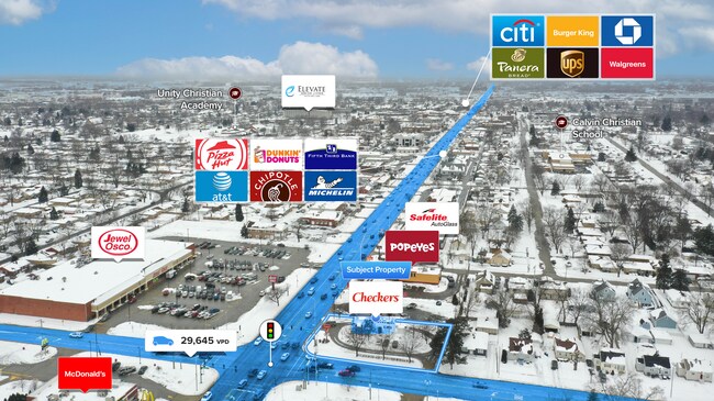
Property Record
730 E 162Nd St, South Holland, IL 60473

NEARBY LISTINGS FOR SALE OR LEASE
Property Detail
730 E 162Nd St
Chicago-Naperville-Elgin, IL-IN-WI
Tys Gouwens
29-15-407-038-0000
Cook
Commercialbuilding
Illinois
X
7
17031C0751J
0.11 AC
2023
Near South Cook
2025
Chicago
827801
DEMOGRAPHICS near 730 E 162Nd St
1 Mile
3 Mile
5 Mile
2024 Total Population
14,979
92,193
255,295
2029 Population
14,595
90,301
251,080
Pop Growth 2024-2029
(2.56%)
(2.05%)
(1.65%)
Average Age
41
41
40
2024 Total Households
5,105
34,661
94,723
HH Growth 2024-2029
(2.78%)
(2.45%)
(1.96%)
Median Household Inc
$69,118
$54,921
$51,408
Avg Household Size
2.80
2.60
2.60
2024 Avg HH Vehicles
2.00
2.00
2.00
Median Home Value
$158,518
$134,364
$135,686
Median Year Built
1964
1966
1961
Nearby Places
Map Layers
Map Styles
 Street
 Aerial
- Restaurants
- Banks
- Shops
- Fitness
- Groceries
PUBLIC TRANSPORTATION
COMMUTER RAIL
Harvey Station (Metra Electric Line - Northeast Illinois Regional Commuter Railroad (Metra))
DRIVE
WALK
Distance
Harvey Station (Metra Electric Line - Northeast Illinois Regional Commuter Railroad (Metra))
7 min
3.2 mi
147Th St. (Metra Electric - Metra)
DRIVE
WALK
Distance
147Th St. (Metra Electric - Metra)
6 min
3.6 mi
AIRPORT
Chicago Midway International
DRIVE
WALK
Distance
Chicago Midway International
33 min
19.5 mi
Freight Ports
Port Milwaukee
DRIVE
WALK
Distance
Port Milwaukee
136 min
108.0 mi
SALE & LEASE HISTORY
LISTING DATE
SALE/LEASE

Mar 15, 2021
For Sale
Jan 15, 2025
For Lease
Jan 15, 2025
For Sale
Nearby Properties
Address
Land Use
TOTAL SIZE
Lot Size
Zoning
Address
Land Use
TOTAL SIZE
Lot Size
Zoning
Address
Land Use
TOTAL SIZE
Lot Size
Zoning
24.56 AC
Address
Land Use
TOTAL SIZE
Lot Size
Zoning
Address
Land Use
TOTAL SIZE
Lot Size
Zoning
1.45 AC
Address
Land Use
TOTAL SIZE
Lot Size
Zoning
6.19 AC
Address
Land Use
TOTAL SIZE
Lot Size
Zoning
5.01 AC
Address
Land Use
TOTAL SIZE
Lot Size
Zoning
48,134 SF
5.33 AC
Address
Land Use
TOTAL SIZE
Lot Size
Zoning
4.85 AC
Address
Land Use
TOTAL SIZE
Lot Size
Zoning
69,894 SF
7.60 AC
Address
Land Use
TOTAL SIZE
Lot Size
Zoning
450,777 SF
25.25 AC
Address
Land Use
TOTAL SIZE
Lot Size
Zoning
454,999 SF
27.43 AC
Address
Land Use
TOTAL SIZE
Lot Size
Zoning
60,864 SF
5.55 AC
Address
Land Use
TOTAL SIZE
Lot Size
Zoning
231,296 SF
10.91 AC
Address
Land Use
TOTAL SIZE
Lot Size
Zoning
7.31 AC
Address
Land Use
TOTAL SIZE
Lot Size
Zoning
40,489 SF
6.43 AC
Address
Land Use
TOTAL SIZE
Lot Size
Zoning
Address
Land Use
TOTAL SIZE
Lot Size
Zoning
2.86 AC
Address
Land Use
TOTAL SIZE
Lot Size
Zoning
Address
Land Use
TOTAL SIZE
Lot Size
Zoning
67,314 SF
1.19 AC
Address
Land Use
TOTAL SIZE
Lot Size
Zoning
44,189 SF
3.09 AC
Address
Land Use
TOTAL SIZE
Lot Size
Zoning
Address
Land Use
TOTAL SIZE
Lot Size
Zoning
27,606 SF
2.87 AC
Address
Land Use
TOTAL SIZE
Lot Size
Zoning
125,535 SF
9.44 AC
Address
Land Use
TOTAL SIZE
Lot Size
Zoning
Address
Land Use
TOTAL SIZE
Lot Size
Zoning
89,853 SF
2.68 AC
Address
Land Use
TOTAL SIZE
Lot Size
Zoning
159,145 SF
15.36 AC
Address
Land Use
TOTAL SIZE
Lot Size
Zoning
165,530 SF
1.82 AC
Address
Land Use
TOTAL SIZE
Lot Size
Zoning
142,376 SF
24 AC
Address
Land Use
TOTAL SIZE
Lot Size
Zoning
27,557 SF
2.92 AC
Address
Land Use
TOTAL SIZE
Lot Size
Zoning
38,111 SF
6.70 AC
The World's #1 Commercial Real Estate Marketplace
Connect with us
© 2026 CoStar Group
The information above has been obtained from sources believed reliable. While we do not doubt its accuracy we have not verified it and make no guarantee, warranty or representation about it. It is your responsibility to independently confirm its accuracy and completeness. Any projections, opinions, assumptions, or estimates used are for example only and do not represent the current or future performance of the property. The value of this transaction to you depends on tax and other factors which should be evaluated by your tax, financial, and legal advisors. You and your advisors should conduct a careful, independent investigation of the property to determine to your satisfaction the suitability of the property for your needs.