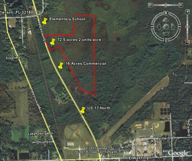
Property Record
730 E Palmetto Rd, Pierson, FL 32180
Save to a Folder
{{folder.Name}}
{{folder.ListingIds.length}} Properties
{{folder.ListingIds.length}} Property
Create a New Folder
Property Detail
730 E Palmetto Rd
Deltona-Daytona Beach-Ormond Beach, FL
21 & 22-14-28 S 640 FT LOT 240 & ALL LOTS 244 249 250 251 & 252 LAKE GEORGE THERMAL ARTESIAN VEGETABLE DELTA & INC SW 1/4 OF SE 1/4 & INC NE 1/4 OF SW 1/4 EXC N 19.60 FT IN 22-14-28 MB 4 PG 165 PER OR 4484 PG 2682 PER OR 6520 PG 3346
4701-01-00-2400
VOLUSIA
Recreationalacreage
Florida
A1
240
B and X Area of moderate flood hazard, usually the area between the limits of the 100-year and 500-year floods.
127.90 AC
2025
NW Volusia County
2026
Deltona/Daytona Beach
090101
NEARBY LISTINGS FOR SALE OR LEASE
-
-
View all Pierson listings for sale on LoopNet.com
DEMOGRAPHICS near 730 E Palmetto Rd
1 mile
3 mile
5 mile
2025 Total Population
431
2,299
3,832
2030 Population
463
2,466
4,118
Pop Growth 2025-2030
+ 7.42%
+ 7.26%
+ 7.46%
Average Age
41
42
42
2025 Total Households
141
797
1,387
HH Growth 2025-2030
+ 7.09%
+ 7.28%
+ 7.43%
Median Household Inc
$58,999
$62,578
$65,092
Avg Household Size
2.90
2.70
2.60
2025 Avg HH Vehicles
2.00
2.00
2.00
Median Home Value
$325,926
$354,220
$368,017
Median Year Built
1983
1983
1983
Nearby Places
Map Layers
Map Styles
 Street
 Aerial
Layers
 Traffic
 Biking
Places
Listings with unknown addresses are not visible on the map
- Restaurants
- Banks
- Shops
- Fitness
- Groceries
PUBLIC TRANSPORTATION
AIRPORT
Daytona Beach International
Drive
Walk
Distance
Daytona Beach International
49 min
34.6 mi
Freight Ports
Jacksonville Port
Drive
Walk
Distance
Jacksonville Port
127 min
101.2 mi
Nearby Properties
Address
Land Use
TOTAL SIZE
Lot Size
Zoning
Address
Land Use
TOTAL SIZE
Lot Size
Zoning
227,542 SF
90.24 AC
Address
Land Use
TOTAL SIZE
Lot Size
Zoning
93,639 SF
23.48 AC
A1
Address
Land Use
TOTAL SIZE
Lot Size
Zoning
46,635 SF
6.17 AC
Address
Land Use
TOTAL SIZE
Lot Size
Zoning
1,778.23 AC
C
Address
Land Use
TOTAL SIZE
Lot Size
Zoning
2,268 SF
11.36 AC
A2
Address
Land Use
TOTAL SIZE
Lot Size
Zoning
27,005 SF
7.38 AC
14A1
Address
Land Use
TOTAL SIZE
Lot Size
Zoning
7,346 SF
160 AC
A1
Address
Land Use
TOTAL SIZE
Lot Size
Zoning
11,564 SF
4.24 AC
Address
Land Use
TOTAL SIZE
Lot Size
Zoning
11,076 SF
145 AC
A2
Address
Land Use
TOTAL SIZE
Lot Size
Zoning
10,672 SF
1.69 AC
Address
Land Use
TOTAL SIZE
Lot Size
Zoning
17,566 SF
2.47 AC
Address
Land Use
TOTAL SIZE
Lot Size
Zoning
4,565 SF
41.82 AC
A1
Address
Land Use
TOTAL SIZE
Lot Size
Zoning
6,327 SF
33 AC
Address
Land Use
TOTAL SIZE
Lot Size
Zoning
28,834 SF
16.02 AC
MPUD
Address
Land Use
TOTAL SIZE
Lot Size
Zoning
4,620 SF
4.81 AC
Address
Land Use
TOTAL SIZE
Lot Size
Zoning
5,232 SF
349.31 AC
RC
Address
Land Use
TOTAL SIZE
Lot Size
Zoning
207 AC
Address
Land Use
TOTAL SIZE
Lot Size
Zoning
4,724 SF
11.20 AC
Address
Land Use
TOTAL SIZE
Lot Size
Zoning
9,748 SF
0.96 AC
Address
Land Use
TOTAL SIZE
Lot Size
Zoning
5,725 SF
9.50 AC
A1
Address
Land Use
TOTAL SIZE
Lot Size
Zoning
8,494 SF
1.24 AC
Address
Land Use
TOTAL SIZE
Lot Size
Zoning
25,120 SF
4 AC
14B2
Address
Land Use
TOTAL SIZE
Lot Size
Zoning
6,458 SF
1 AC
A1
Address
Land Use
TOTAL SIZE
Lot Size
Zoning
6,782 SF
17.66 AC
RC
Address
Land Use
TOTAL SIZE
Lot Size
Zoning
4,500 SF
24.24 AC
A2
Address
Land Use
TOTAL SIZE
Lot Size
Zoning
7,838 SF
0.49 AC
Address
Land Use
TOTAL SIZE
Lot Size
Zoning
3,666 SF
20.10 AC
A1
Address
Land Use
TOTAL SIZE
Lot Size
Zoning
7,000 SF
3 AC
Address
Land Use
TOTAL SIZE
Lot Size
Zoning
27,211 SF
15.68 AC
Address
Land Use
TOTAL SIZE
Lot Size
Zoning
5,310 SF
3.35 AC
The World's #1 Commercial Real Estate Marketplace
Connect with us
© 2026 CoStar Group
The information above has been obtained from sources believed reliable. While we do not doubt its accuracy we have not verified it and make no guarantee, warranty or representation about it. It is your responsibility to independently confirm its accuracy and completeness. Any projections, opinions, assumptions, or estimates used are for example only and do not represent the current or future performance of the property. The value of this transaction to you depends on tax and other factors which should be evaluated by your tax, financial, and legal advisors. You and your advisors should conduct a careful, independent investigation of the property to determine to your satisfaction the suitability of the property for your needs.