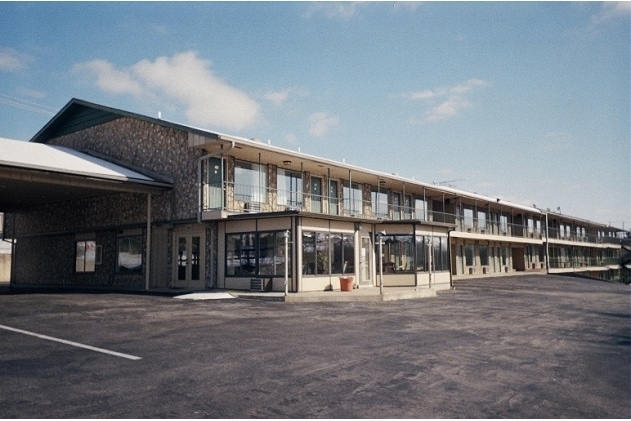
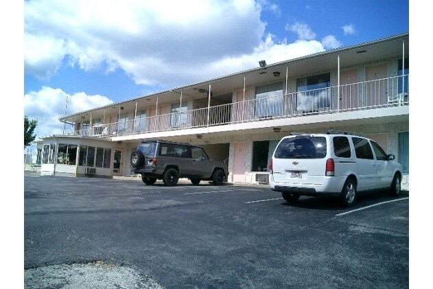
Property Record
730 State Highway 165, Branson, MO 65616

Save to a Folder
{{folder.Name}}
{{folder.ListingIds.length}} Properties
{{folder.ListingIds.length}} Property
Create a New Folder
Property Detail
730 State Highway 165
18-1.0-11-001-002-004.000
PT W2 NENE4 E OF MSH 165; CITY OF BRANSON
Commercialnec
Taney
B and X Area of moderate flood hazard, usually the area between the limits of the 100-year and 500-year floods.
Missouri
2024
1.77 AC
2025
Branson
480108
Other Market Areas
11,067 SF
Branson, MO
NEARBY LISTINGS FOR SALE OR LEASE
DEMOGRAPHICS near 730 State Highway 165
1 mile
3 mile
5 mile
2025 Total Population
2,495
15,204
31,060
2030 Population
2,586
15,615
31,705
Pop Growth 2025-2030
+ 3.65%
+ 2.70%
+ 2.08%
Average Age
43
42
43
2025 Total Households
1,119
6,038
12,987
HH Growth 2025-2030
+ 3.49%
+ 3.08%
+ 2.36%
Median Household Inc
$47,987
$55,744
$60,670
Avg Household Size
2.20
2.10
2.20
2025 Avg HH Vehicles
2.00
2.00
2.00
Median Home Value
$232,285
$237,414
$250,508
Median Year Built
1996
1996
1996
Nearby Places
Map Layers
Map Styles
 Street
 Aerial
Layers
 Traffic
 Biking
Places
Listings with unknown addresses are not visible on the map
- Restaurants
- Banks
- Shops
- Fitness
- Groceries
SALE & LEASE HISTORY
LISTING DATE
SALE/LEASE

Sep 24, 2016
For Sale
Oct 04, 2016
For Sale
Nearby Properties
Address
Land Use
TOTAL SIZE
Lot Size
Zoning
Address
Land Use
TOTAL SIZE
Lot Size
Zoning
107,469 SF
21.35 AC
Address
Land Use
TOTAL SIZE
Lot Size
Zoning
350,270 SF
40 AC
Address
Land Use
TOTAL SIZE
Lot Size
Zoning
140,093 SF
8.37 AC
Address
Land Use
TOTAL SIZE
Lot Size
Zoning
26,658 SF
6.30 AC
Address
Land Use
TOTAL SIZE
Lot Size
Zoning
43,276 SF
5.93 AC
Address
Land Use
TOTAL SIZE
Lot Size
Zoning
18,781 SF
4.70 AC
Address
Land Use
TOTAL SIZE
Lot Size
Zoning
135,214 SF
13.91 AC
Address
Land Use
TOTAL SIZE
Lot Size
Zoning
27,496 SF
3.34 AC
Address
Land Use
TOTAL SIZE
Lot Size
Zoning
12,542 SF
3.87 AC
Address
Land Use
TOTAL SIZE
Lot Size
Zoning
32,464 SF
2.16 AC
Address
Land Use
TOTAL SIZE
Lot Size
Zoning
45,680 SF
11.85 AC
Address
Land Use
TOTAL SIZE
Lot Size
Zoning
55,651 SF
3.95 AC
Address
Land Use
TOTAL SIZE
Lot Size
Zoning
85,644 SF
6.64 AC
Address
Land Use
TOTAL SIZE
Lot Size
Zoning
53,728 SF
6.74 AC
Address
Land Use
TOTAL SIZE
Lot Size
Zoning
17,313 SF
5.18 AC
Address
Land Use
TOTAL SIZE
Lot Size
Zoning
48,182 SF
15 AC
Address
Land Use
TOTAL SIZE
Lot Size
Zoning
51,842 SF
3.48 AC
Address
Land Use
TOTAL SIZE
Lot Size
Zoning
51,904 SF
5.08 AC
Address
Land Use
TOTAL SIZE
Lot Size
Zoning
28,639 SF
2.51 AC
Address
Land Use
TOTAL SIZE
Lot Size
Zoning
18,330 SF
2.80 AC
Address
Land Use
TOTAL SIZE
Lot Size
Zoning
10,860 SF
0.29 AC
Address
Land Use
TOTAL SIZE
Lot Size
Zoning
39,644 SF
7.02 AC
Address
Land Use
TOTAL SIZE
Lot Size
Zoning
49,886 SF
8.16 AC
Address
Land Use
TOTAL SIZE
Lot Size
Zoning
19,196 SF
2.78 AC
Address
Land Use
TOTAL SIZE
Lot Size
Zoning
118,200 SF
4.20 AC
Address
Land Use
TOTAL SIZE
Lot Size
Zoning
14,616 SF
1.97 AC
Address
Land Use
TOTAL SIZE
Lot Size
Zoning
104,062 SF
2.63 AC
Address
Land Use
TOTAL SIZE
Lot Size
Zoning
43,445 SF
4.36 AC
Address
Land Use
TOTAL SIZE
Lot Size
Zoning
20,617 SF
2.18 AC
Address
Land Use
TOTAL SIZE
Lot Size
Zoning
10,783 SF
0.32 AC
The World's #1 Commercial Real Estate Marketplace
Connect with us
© 2026 CoStar Group
The information above has been obtained from sources believed reliable. While we do not doubt its accuracy we have not verified it and make no guarantee, warranty or representation about it. It is your responsibility to independently confirm its accuracy and completeness. Any projections, opinions, assumptions, or estimates used are for example only and do not represent the current or future performance of the property. The value of this transaction to you depends on tax and other factors which should be evaluated by your tax, financial, and legal advisors. You and your advisors should conduct a careful, independent investigation of the property to determine to your satisfaction the suitability of the property for your needs.