Property Record
730 Highway 378, Lexington, SC 29072


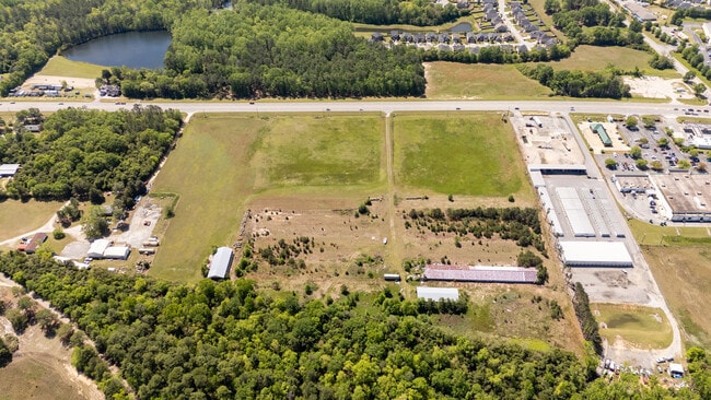
This Property Is For Sale
NEARBY LISTINGS FOR SALE OR LEASE
Property Detail
730 Highway 378
Columbia, SC
Lands Of Mrs Fannie Roof
004200-07-011
NONE HWY ROW TAKEN 1.07 AC
Commercialnec
Lexington
X
South Carolina
45063C0231J
24.64 AC
2025
Lexington
2024
Columbia
021050
DEMOGRAPHICS near 730 Highway 378
1 Mile
3 Mile
5 Mile
2024 Total Population
2,981
26,779
59,635
2029 Population
3,430
30,946
69,116
Pop Growth 2024-2029
+ 15.06%
+ 15.56%
+ 15.90%
Average Age
36
40
40
2024 Total Households
1,034
9,828
22,411
HH Growth 2024-2029
+ 15.57%
+ 16.09%
+ 16.48%
Median Household Inc
$115,018
$109,379
$103,261
Avg Household Size
2.90
2.70
2.60
2024 Avg HH Vehicles
2.00
2.00
2.00
Median Home Value
$288,174
$326,873
$313,996
Median Year Built
2009
2003
2001
Nearby Places
Map Layers
Map Styles
 Street
 Aerial
- Restaurants
- Banks
- Shops
- Fitness
- Groceries
PUBLIC TRANSPORTATION
AIRPORT
Columbia Metro
DRIVE
WALK
Distance
Columbia Metro
35 min
16.5 mi
Freight Ports
North Charleston Terminal
DRIVE
WALK
Distance
North Charleston Terminal
136 min
114.4 mi
Nearby Properties
Address
Land Use
TOTAL SIZE
Lot Size
Zoning
Address
Land Use
TOTAL SIZE
Lot Size
Zoning
45,171 SF
8.38 AC
ID
Address
Land Use
TOTAL SIZE
Lot Size
Zoning
82.61 AC
Address
Land Use
TOTAL SIZE
Lot Size
Zoning
9,792 SF
7.47 AC
HDR
Address
Land Use
TOTAL SIZE
Lot Size
Zoning
96,585 SF
2.62 AC
ID
Address
Land Use
TOTAL SIZE
Lot Size
Zoning
41,883 SF
21.77 AC
ID
Address
Land Use
TOTAL SIZE
Lot Size
Zoning
49,494 SF
9.98 AC
ID
Address
Land Use
TOTAL SIZE
Lot Size
Zoning
78,665 SF
7.58 AC
GC
Address
Land Use
TOTAL SIZE
Lot Size
Zoning
18,300 SF
3.33 AC
RD
Address
Land Use
TOTAL SIZE
Lot Size
Zoning
3,810 SF
1.58 AC
ID
Address
Land Use
TOTAL SIZE
Lot Size
Zoning
86,573 SF
4.92 AC
Address
Land Use
TOTAL SIZE
Lot Size
Zoning
1,378 SF
125.89 AC
RD
Address
Land Use
TOTAL SIZE
Lot Size
Zoning
6,760 SF
1.50 AC
ID
Address
Land Use
TOTAL SIZE
Lot Size
Zoning
9,918 SF
2.13 AC
RD
Address
Land Use
TOTAL SIZE
Lot Size
Zoning
4,850 SF
1.88 AC
ID
Address
Land Use
TOTAL SIZE
Lot Size
Zoning
12,600 SF
2.06 AC
ID
Address
Land Use
TOTAL SIZE
Lot Size
Zoning
121.12 AC
RD
Address
Land Use
TOTAL SIZE
Lot Size
Zoning
39,473 SF
5.95 AC
ID
Address
Land Use
TOTAL SIZE
Lot Size
Zoning
5,175 SF
1.61 AC
ID
Address
Land Use
TOTAL SIZE
Lot Size
Zoning
4,098 SF
0.99 AC
ID
Address
Land Use
TOTAL SIZE
Lot Size
Zoning
10,776 SF
2.10 AC
ID
Address
Land Use
TOTAL SIZE
Lot Size
Zoning
14,494 SF
2.17 AC
ID
Address
Land Use
TOTAL SIZE
Lot Size
Zoning
5,707 SF
1.02 AC
RD
Address
Land Use
TOTAL SIZE
Lot Size
Zoning
1,800 SF
43.80 AC
ID
Address
Land Use
TOTAL SIZE
Lot Size
Zoning
13,870 SF
3.55 AC
ID
Address
Land Use
TOTAL SIZE
Lot Size
Zoning
63,569 SF
3.21 AC
Address
Land Use
TOTAL SIZE
Lot Size
Zoning
1,042 SF
6.25 AC
ID
Address
Land Use
TOTAL SIZE
Lot Size
Zoning
5,029 SF
1.84 AC
ID
Address
Land Use
TOTAL SIZE
Lot Size
Zoning
4,800 SF
4.55 AC
ID
Address
Land Use
TOTAL SIZE
Lot Size
Zoning
13,231 SF
2.40 AC
ID
Address
Land Use
TOTAL SIZE
Lot Size
Zoning
4,400 SF
5.14 AC
ID
The World's #1 Commercial Real Estate Marketplace
Connect with us
© 2025 CoStar Group
The information above has been obtained from sources believed reliable. While we do not doubt its accuracy we have not verified it and make no guarantee, warranty or representation about it. It is your responsibility to independently confirm its accuracy and completeness. Any projections, opinions, assumptions, or estimates used are for example only and do not represent the current or future performance of the property. The value of this transaction to you depends on tax and other factors which should be evaluated by your tax, financial, and legal advisors. You and your advisors should conduct a careful, independent investigation of the property to determine to your satisfaction the suitability of the property for your needs.