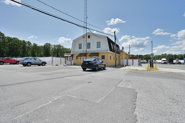
Property Record
730 W White Horse Pike, Absecon, NJ 08201


Current Lease Availabilities
Industrial LEASE
$18.87 - $19.90 SF/YR
1,272 - 4,190 SF
NEARBY LISTINGS FOR SALE OR LEASE
Property Detail
730 W White Horse Pike
11-00320-0000-00002
RYDER TRANSPORTATION
Officebuilding
Atlantic
ARE
New Jersey
34001C0165F
2
2024
5.91 AC
2025
Atlantic City/Hammonton
010200
Philadelphia
9,772 SF
Atlantic City-Hammonton, NJ
DEMOGRAPHICS near 730 W White Horse Pike
1 Mile
3 Mile
5 Mile
2024 Total Population
846
9,790
32,770
2029 Population
822
9,589
32,196
Pop Growth 2024-2029
(2.84%)
(2.05%)
(1.75%)
Average Age
46
41
39
2024 Total Households
346
3,585
10,923
HH Growth 2024-2029
(3.47%)
(2.71%)
(2.49%)
Median Household Inc
$101,765
$73,806
$75,676
Avg Household Size
2.30
2.50
2.60
2024 Avg HH Vehicles
3.00
2.00
2.00
Median Home Value
$258,992
$228,508
$226,493
Median Year Built
1985
1977
1985
Nearby Places
Map Layers
Map Styles
 Street
 Aerial
- Restaurants
- Banks
- Shops
- Fitness
- Groceries
PUBLIC TRANSPORTATION
COMMUTER RAIL
Egg Harbor City (Atlantic City Line - NJ Transit Commuter Rail (NJ Transit))
DRIVE
WALK
Distance
Egg Harbor City (Atlantic City Line - NJ Transit Commuter Rail (NJ Transit))
5 min
2.9 mi
Absecon (Atlantic City Line - NJ Transit Commuter Rail (NJ Transit))
DRIVE
WALK
Distance
Absecon (Atlantic City Line - NJ Transit Commuter Rail (NJ Transit))
10 min
8.1 mi
AIRPORT
Atlantic City International
DRIVE
WALK
Distance
Atlantic City International
27 min
6.8 mi
Freight Ports
Broadway Terminal - Pier 5
DRIVE
WALK
Distance
Broadway Terminal - Pier 5
56 min
42.5 mi
Nearby Properties
Address
Land Use
TOTAL SIZE
Lot Size
Zoning
Address
Land Use
TOTAL SIZE
Lot Size
Zoning
52.37 AC
GA-I
Address
Land Use
TOTAL SIZE
Lot Size
Zoning
5.81 AC
CC
Address
Land Use
TOTAL SIZE
Lot Size
Zoning
35.65 AC
IRD
Address
Land Use
TOTAL SIZE
Lot Size
Zoning
68,744 SF
5.03 AC
R-11
Address
Land Use
TOTAL SIZE
Lot Size
Zoning
94,984 SF
2.07 AC
R-9
Address
Land Use
TOTAL SIZE
Lot Size
Zoning
4.50 AC
R-1
Address
Land Use
TOTAL SIZE
Lot Size
Zoning
16.39 AC
R-1
Address
Land Use
TOTAL SIZE
Lot Size
Zoning
Address
Land Use
TOTAL SIZE
Lot Size
Zoning
2.27 AC
R-9
Address
Land Use
TOTAL SIZE
Lot Size
Zoning
70.67 AC
RD-5
Address
Land Use
TOTAL SIZE
Lot Size
Zoning
90.90 AC
RD-5
Address
Land Use
TOTAL SIZE
Lot Size
Zoning
Address
Land Use
TOTAL SIZE
Lot Size
Zoning
21,056 SF
5.23 AC
IND
Address
Land Use
TOTAL SIZE
Lot Size
Zoning
Address
Land Use
TOTAL SIZE
Lot Size
Zoning
1,056 SF
11.56 AC
I
Address
Land Use
TOTAL SIZE
Lot Size
Zoning
4,652 SF
14.80 AC
HC-2
Address
Land Use
TOTAL SIZE
Lot Size
Zoning
1,390 SF
1.92 AC
HC-2
Address
Land Use
TOTAL SIZE
Lot Size
Zoning
Address
Land Use
TOTAL SIZE
Lot Size
Zoning
12,673 SF
2.58 AC
R-9
Address
Land Use
TOTAL SIZE
Lot Size
Zoning
Address
Land Use
TOTAL SIZE
Lot Size
Zoning
14,546 SF
0.48 AC
R-C
Address
Land Use
TOTAL SIZE
Lot Size
Zoning
2.73 AC
HC-2
Address
Land Use
TOTAL SIZE
Lot Size
Zoning
15,974 SF
2.87 AC
H-C
Address
Land Use
TOTAL SIZE
Lot Size
Zoning
526.84 AC
FATC
Address
Land Use
TOTAL SIZE
Lot Size
Zoning
31.90 AC
TI
Address
Land Use
TOTAL SIZE
Lot Size
Zoning
27,200 SF
5.27 AC
HC-2
Address
Land Use
TOTAL SIZE
Lot Size
Zoning
6,256 SF
4.55 AC
R-22
Address
Land Use
TOTAL SIZE
Lot Size
Zoning
8.40 AC
HC-1
Address
Land Use
TOTAL SIZE
Lot Size
Zoning
31.06 AC
IRD
Address
Land Use
TOTAL SIZE
Lot Size
Zoning
3.10 AC
VR
The World's #1 Commercial Real Estate Marketplace
Connect with us
© 2026 CoStar Group
The information above has been obtained from sources believed reliable. While we do not doubt its accuracy we have not verified it and make no guarantee, warranty or representation about it. It is your responsibility to independently confirm its accuracy and completeness. Any projections, opinions, assumptions, or estimates used are for example only and do not represent the current or future performance of the property. The value of this transaction to you depends on tax and other factors which should be evaluated by your tax, financial, and legal advisors. You and your advisors should conduct a careful, independent investigation of the property to determine to your satisfaction the suitability of the property for your needs.