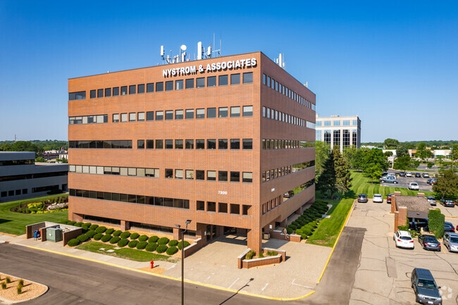
Property Record
7300 147Th St W, Saint Paul, MN 55124

Current Lease Availabilities
NEARBY LISTINGS FOR SALE OR LEASE
Property Detail
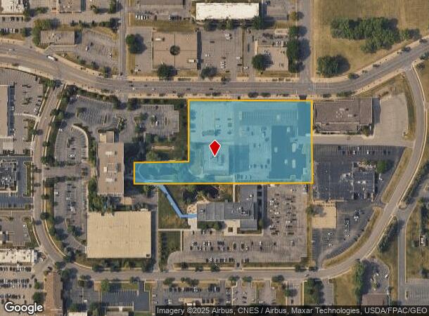
7300 147Th St W
Minneapolis-St. Paul-Bloomington, MN-WI
Apple Valley Commons
01-11740-01-010
APPLE VALLEY COMMONS 1 1
Commercialnec
Dakota
X
Minnesota
27037C0202E
10
2024
4.12 AC
2024
Burnsville/Eagan/Apple Vy
060824
Minneapolis/St Paul
60,589 SF
DEMOGRAPHICS near 7300 147Th St W
1 Mile
3 Mile
5 Mile
2024 Total Population
14,652
92,981
208,833
2029 Population
15,130
94,932
213,525
Pop Growth 2024-2029
+ 3.26%
+ 2.10%
+ 2.25%
Average Age
42
39
39
2024 Total Households
6,134
34,125
77,846
HH Growth 2024-2029
+ 3.52%
+ 2.22%
+ 2.35%
Median Household Inc
$69,647
$99,535
$99,255
Avg Household Size
2.30
2.60
2.60
2024 Avg HH Vehicles
2.00
2.00
2.00
Median Home Value
$285,889
$333,394
$334,343
Median Year Built
1995
1989
1989
Nearby Places
Map Layers
Map Styles
 Street
 Aerial
- Restaurants
- Banks
- Shops
- Fitness
- Groceries
PUBLIC TRANSPORTATION
AIRPORT
Minneapolis-St Paul International/Wold-Chamberlain
DRIVE
WALK
Distance
Minneapolis-St Paul International/Wold-Chamberlain
19 min
11.7 mi
Freight Ports
Port Milwaukee
DRIVE
WALK
Distance
Port Milwaukee
382 min
344.9 mi
Nearby Properties
Address
Land Use
TOTAL SIZE
Lot Size
Zoning
Address
Land Use
TOTAL SIZE
Lot Size
Zoning
519,392 SF
17.66 AC
Address
Land Use
TOTAL SIZE
Lot Size
Zoning
124,880 SF
20.24 AC
Address
Land Use
TOTAL SIZE
Lot Size
Zoning
435,642 SF
12.28 AC
Address
Land Use
TOTAL SIZE
Lot Size
Zoning
413,138 SF
11.86 AC
Address
Land Use
TOTAL SIZE
Lot Size
Zoning
312,292 SF
4.77 AC
Address
Land Use
TOTAL SIZE
Lot Size
Zoning
98,397 SF
12.42 AC
Address
Land Use
TOTAL SIZE
Lot Size
Zoning
24,750 SF
14.36 AC
Address
Land Use
TOTAL SIZE
Lot Size
Zoning
269,828 SF
3.58 AC
Address
Land Use
TOTAL SIZE
Lot Size
Zoning
361,645 SF
75.60 AC
Address
Land Use
TOTAL SIZE
Lot Size
Zoning
18,687 SF
7.71 AC
Address
Land Use
TOTAL SIZE
Lot Size
Zoning
277,504 SF
5.27 AC
Address
Land Use
TOTAL SIZE
Lot Size
Zoning
351,484 SF
57.09 AC
Address
Land Use
TOTAL SIZE
Lot Size
Zoning
Address
Land Use
TOTAL SIZE
Lot Size
Zoning
278,440 SF
13.61 AC
Address
Land Use
TOTAL SIZE
Lot Size
Zoning
273,843 SF
17.55 AC
Address
Land Use
TOTAL SIZE
Lot Size
Zoning
193,413 SF
2.95 AC
Address
Land Use
TOTAL SIZE
Lot Size
Zoning
207,187 SF
2.45 AC
Address
Land Use
TOTAL SIZE
Lot Size
Zoning
232,598 SF
3.61 AC
Address
Land Use
TOTAL SIZE
Lot Size
Zoning
181,880 SF
3.23 AC
Address
Land Use
TOTAL SIZE
Lot Size
Zoning
179,476 SF
2.46 AC
Address
Land Use
TOTAL SIZE
Lot Size
Zoning
168,324 SF
2.66 AC
Address
Land Use
TOTAL SIZE
Lot Size
Zoning
134,140 SF
6.39 AC
Address
Land Use
TOTAL SIZE
Lot Size
Zoning
Address
Land Use
TOTAL SIZE
Lot Size
Zoning
242,484 SF
31.67 AC
Address
Land Use
TOTAL SIZE
Lot Size
Zoning
226,621 SF
35.56 AC
Address
Land Use
TOTAL SIZE
Lot Size
Zoning
1.64 AC
Address
Land Use
TOTAL SIZE
Lot Size
Zoning
130,876 SF
11.25 AC
Address
Land Use
TOTAL SIZE
Lot Size
Zoning
246,662 SF
22.62 AC
The World's #1 Commercial Real Estate Marketplace
Connect with us
© 2025 CoStar Group
The information above has been obtained from sources believed reliable. While we do not doubt its accuracy we have not verified it and make no guarantee, warranty or representation about it. It is your responsibility to independently confirm its accuracy and completeness. Any projections, opinions, assumptions, or estimates used are for example only and do not represent the current or future performance of the property. The value of this transaction to you depends on tax and other factors which should be evaluated by your tax, financial, and legal advisors. You and your advisors should conduct a careful, independent investigation of the property to determine to your satisfaction the suitability of the property for your needs.