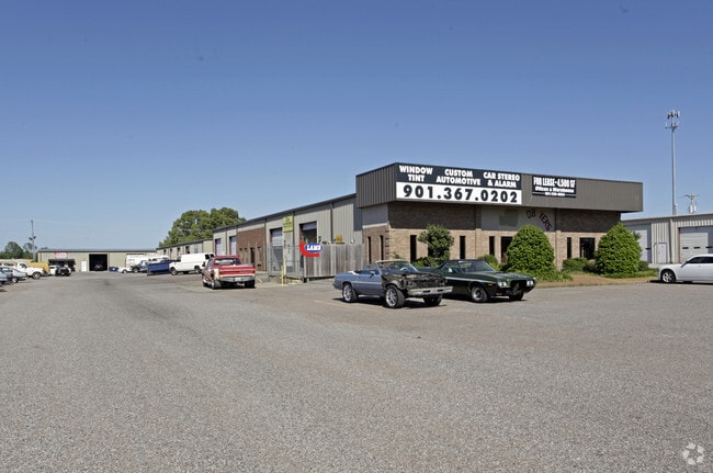
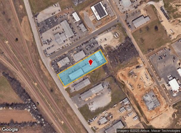
Property Record
7300 Craft Goodman Rd, Olive Branch, MS 38654

NEARBY LISTINGS FOR SALE OR LEASE
Property Detail
7300 Craft Goodman Rd
Memphis, TN-MS-AR
Craft Road Commercial Plaza
1069291500000900
CRAFT ROAD COMMERCIAL PLAZA LOT 9
Commercialnec
DeSoto
X
Mississippi
28033C0101H
9
2025
1.80 AC
2025
DeSoto
070811
Memphis
9,600 SF
DEMOGRAPHICS near 7300 Craft Goodman Rd
1 Mile
3 Mile
5 Mile
2024 Total Population
3,207
34,323
101,453
2029 Population
3,487
36,518
104,953
Pop Growth 2024-2029
+ 8.73%
+ 6.40%
+ 3.45%
Average Age
41
39
38
2024 Total Households
1,150
12,649
36,265
HH Growth 2024-2029
+ 8.87%
+ 6.44%
+ 3.50%
Median Household Inc
$77,115
$76,723
$72,940
Avg Household Size
2.70
2.70
2.80
2024 Avg HH Vehicles
2.00
2.00
2.00
Median Home Value
$235,339
$232,432
$218,049
Median Year Built
1992
1997
1992
Nearby Places
Map Layers
Map Styles
 Street
 Aerial
- Restaurants
- Banks
- Shops
- Fitness
- Groceries
PUBLIC TRANSPORTATION
AIRPORT
Memphis International
DRIVE
WALK
Distance
Memphis International
20 min
10.7 mi
SALE & LEASE HISTORY
LISTING DATE
SALE/LEASE

Sep 17, 2019
For Lease
Aug 26, 2025
For Lease
Nearby Properties
Address
Land Use
TOTAL SIZE
Lot Size
Zoning
Address
Land Use
TOTAL SIZE
Lot Size
Zoning
863,591 SF
35.66 AC
EMP
Address
Land Use
TOTAL SIZE
Lot Size
Zoning
921,576 SF
25.20 AC
CA
Address
Land Use
TOTAL SIZE
Lot Size
Zoning
834,463 SF
37.46 AC
EMP
Address
Land Use
TOTAL SIZE
Lot Size
Zoning
461,807 SF
28.93 AC
EMP
Address
Land Use
TOTAL SIZE
Lot Size
Zoning
434,122 SF
23.97 AC
R-6
Address
Land Use
TOTAL SIZE
Lot Size
Zoning
158,366 SF
24.31 AC
R-6
Address
Land Use
TOTAL SIZE
Lot Size
Zoning
326,743 SF
22.91 AC
R-8
Address
Land Use
TOTAL SIZE
Lot Size
Zoning
345,770 SF
18.13 AC
EMP
Address
Land Use
TOTAL SIZE
Lot Size
Zoning
903,083 SF
45.12 AC
EMP
Address
Land Use
TOTAL SIZE
Lot Size
Zoning
350,298 SF
12.68 AC
EMP
Address
Land Use
TOTAL SIZE
Lot Size
Zoning
330,758 SF
12.09 AC
EMP
Address
Land Use
TOTAL SIZE
Lot Size
Zoning
667,793 SF
35.26 AC
IH
Address
Land Use
TOTAL SIZE
Lot Size
Zoning
554,282 SF
67.63 AC
IH
Address
Land Use
TOTAL SIZE
Lot Size
Zoning
689,307 SF
22.68 AC
EMP
Address
Land Use
TOTAL SIZE
Lot Size
Zoning
642,900 SF
29.71 AC
EMP
Address
Land Use
TOTAL SIZE
Lot Size
Zoning
573,825 SF
32.39 AC
EMP
Address
Land Use
TOTAL SIZE
Lot Size
Zoning
447,385 SF
25.73 AC
IH
Address
Land Use
TOTAL SIZE
Lot Size
Zoning
466,532 SF
21.76 AC
EMP
Address
Land Use
TOTAL SIZE
Lot Size
Zoning
414,374 SF
19.74 AC
EMP
Address
Land Use
TOTAL SIZE
Lot Size
Zoning
864,054 SF
72.19 AC
M-1
Address
Land Use
TOTAL SIZE
Lot Size
Zoning
3,437 SF
169.11 AC
CA
Address
Land Use
TOTAL SIZE
Lot Size
Zoning
421,766 SF
26.26 AC
IH
Address
Land Use
TOTAL SIZE
Lot Size
Zoning
379,348 SF
23.82 AC
IH
Address
Land Use
TOTAL SIZE
Lot Size
Zoning
364,578 SF
19.76 AC
IH
Address
Land Use
TOTAL SIZE
Lot Size
Zoning
366,046 SF
22.37 AC
CA
Address
Land Use
TOTAL SIZE
Lot Size
Zoning
640,640 SF
28.77 AC
EMP
Address
Land Use
TOTAL SIZE
Lot Size
Zoning
307,100 SF
18.95 AC
CA
Address
Land Use
TOTAL SIZE
Lot Size
Zoning
277,936 SF
15.92 AC
EMP
Address
Land Use
TOTAL SIZE
Lot Size
Zoning
309,885 SF
17.49 AC
R-8
Address
Land Use
TOTAL SIZE
Lot Size
Zoning
512,274 SF
49.39 AC
IH
The World's #1 Commercial Real Estate Marketplace
Connect with us
© 2026 CoStar Group
The information above has been obtained from sources believed reliable. While we do not doubt its accuracy we have not verified it and make no guarantee, warranty or representation about it. It is your responsibility to independently confirm its accuracy and completeness. Any projections, opinions, assumptions, or estimates used are for example only and do not represent the current or future performance of the property. The value of this transaction to you depends on tax and other factors which should be evaluated by your tax, financial, and legal advisors. You and your advisors should conduct a careful, independent investigation of the property to determine to your satisfaction the suitability of the property for your needs.