Property Record
7300 Millhouse Rd, Chapel Hill, NC 27516


NEARBY LISTINGS FOR SALE OR LEASE
-
-
View all Chapel Hill listings for sale on LoopNet.com
Property Detail
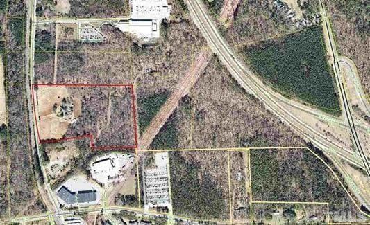
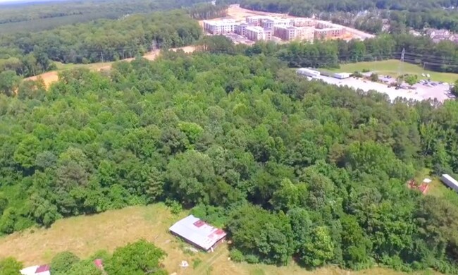
7300 Millhouse Rd
9870892007
Property Of Mrs Sallie N Davis
Industrialgeneral
E/S MILL HOUSE RD (SR 1725)
AE
Orange
3710987000K
North Carolina
2025
19.65 AC
2025
Orange County
011207
Raleigh/Durham
70,300 SF
Durham-Chapel Hill, NC
DEMOGRAPHICS near 7300 Millhouse Rd
1 Mile
3 Mile
5 Mile
2024 Total Population
2,086
20,570
76,607
2029 Population
1,937
18,864
71,314
Pop Growth 2024-2029
(7.14%)
(8.29%)
(6.91%)
Average Age
37
40
37
2024 Total Households
796
7,956
30,592
HH Growth 2024-2029
(7.66%)
(8.53%)
(7.25%)
Median Household Inc
$121,036
$114,628
$81,982
Avg Household Size
2.60
2.50
2.30
2024 Avg HH Vehicles
2.00
2.00
2.00
Median Home Value
$443,292
$488,145
$435,643
Median Year Built
2003
1994
1987
Nearby Places
Map Layers
Map Styles
 Street
 Aerial
- Restaurants
- Banks
- Shops
- Fitness
- Groceries
PUBLIC TRANSPORTATION
AIRPORT
Raleigh-Durham International
DRIVE
WALK
Distance
Raleigh-Durham International
28 min
20.9 mi
Freight Ports
Virginia Port Authority - Richmond
DRIVE
WALK
Distance
Virginia Port Authority - Richmond
184 min
159.6 mi
SALE & LEASE HISTORY
LISTING DATE
SALE/LEASE

Jul 19, 2018
For Sale
Nearby Properties
Address
Land Use
TOTAL SIZE
Lot Size
Zoning
Address
Land Use
TOTAL SIZE
Lot Size
Zoning
208,406 SF
120.44 AC
R1
Address
Land Use
TOTAL SIZE
Lot Size
Zoning
4,128 SF
678.68 AC
R1
Address
Land Use
TOTAL SIZE
Lot Size
Zoning
80,120 SF
101.81 AC
Address
Land Use
TOTAL SIZE
Lot Size
Zoning
100,973 SF
12.96 AC
Address
Land Use
TOTAL SIZE
Lot Size
Zoning
134,448 SF
59.23 AC
Address
Land Use
TOTAL SIZE
Lot Size
Zoning
106,812 SF
19.25 AC
Address
Land Use
TOTAL SIZE
Lot Size
Zoning
21,078 SF
227.43 AC
OI3R2
Address
Land Use
TOTAL SIZE
Lot Size
Zoning
258,730 SF
3.66 AC
Address
Land Use
TOTAL SIZE
Lot Size
Zoning
85,652 SF
16.49 AC
R1R5
Address
Land Use
TOTAL SIZE
Lot Size
Zoning
17,640 SF
11.51 AC
R4R5C
Address
Land Use
TOTAL SIZE
Lot Size
Zoning
35.78 AC
Address
Land Use
TOTAL SIZE
Lot Size
Zoning
156,220 SF
70.70 AC
Address
Land Use
TOTAL SIZE
Lot Size
Zoning
13,912 SF
18.61 AC
NCR5
Address
Land Use
TOTAL SIZE
Lot Size
Zoning
42,628 SF
6.12 AC
Address
Land Use
TOTAL SIZE
Lot Size
Zoning
80,208 SF
10.07 AC
Address
Land Use
TOTAL SIZE
Lot Size
Zoning
66,217 SF
9.77 AC
Address
Land Use
TOTAL SIZE
Lot Size
Zoning
28,857 SF
33.24 AC
R2R5C
Address
Land Use
TOTAL SIZE
Lot Size
Zoning
12,612 SF
7.26 AC
R5
Address
Land Use
TOTAL SIZE
Lot Size
Zoning
37,912 SF
63.39 AC
Address
Land Use
TOTAL SIZE
Lot Size
Zoning
91,083 SF
16.71 AC
Address
Land Use
TOTAL SIZE
Lot Size
Zoning
124,924 SF
1.97 AC
Address
Land Use
TOTAL SIZE
Lot Size
Zoning
50,621 SF
13.39 AC
RB
Address
Land Use
TOTAL SIZE
Lot Size
Zoning
36,000 SF
12.90 AC
Address
Land Use
TOTAL SIZE
Lot Size
Zoning
19,560 SF
24.36 AC
Address
Land Use
TOTAL SIZE
Lot Size
Zoning
23,850 SF
12.13 AC
Address
Land Use
TOTAL SIZE
Lot Size
Zoning
56,418 SF
9.69 AC
Address
Land Use
TOTAL SIZE
Lot Size
Zoning
9,028 SF
63.42 AC
MUR1RB
Address
Land Use
TOTAL SIZE
Lot Size
Zoning
13,881 SF
1.77 AC
Address
Land Use
TOTAL SIZE
Lot Size
Zoning
688.30 AC
Address
Land Use
TOTAL SIZE
Lot Size
Zoning
22,778 SF
41.80 AC
The World's #1 Commercial Real Estate Marketplace
Connect with us
© 2025 CoStar Group
The information above has been obtained from sources believed reliable. While we do not doubt its accuracy we have not verified it and make no guarantee, warranty or representation about it. It is your responsibility to independently confirm its accuracy and completeness. Any projections, opinions, assumptions, or estimates used are for example only and do not represent the current or future performance of the property. The value of this transaction to you depends on tax and other factors which should be evaluated by your tax, financial, and legal advisors. You and your advisors should conduct a careful, independent investigation of the property to determine to your satisfaction the suitability of the property for your needs.