Property Record
7300 Southwind Dr, Chesterfield, VA 23832

NEARBY LISTINGS FOR SALE OR LEASE
-
-
View all Chesterfield listings for sale on LoopNet.com
Property Detail
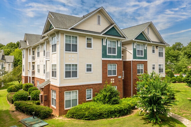
7300 Southwind Dr
716-67-01-30-500-000
S/L Hull Street Rd Parcel A
Apartment
S/L HULL STREET RD PARCEL A
X
Chesterfield
51145C0300C
Virginia
0
24.56 AC
2025
Chesterfield County
101009
Richmond VA
95,857 SF
Richmond, VA
DEMOGRAPHICS near 7300 Southwind Dr
1 Mile
3 Mile
5 Mile
2024 Total Population
8,438
46,666
85,321
2029 Population
9,317
51,714
94,439
Pop Growth 2024-2029
+ 10.42%
+ 10.82%
+ 10.69%
Average Age
37
38
39
2024 Total Households
2,820
15,633
30,032
HH Growth 2024-2029
+ 10.50%
+ 10.78%
+ 10.71%
Median Household Inc
$119,707
$130,722
$120,271
Avg Household Size
3.00
3.00
2.80
2024 Avg HH Vehicles
2.00
2.00
2.00
Median Home Value
$374,999
$374,489
$364,692
Median Year Built
2001
2002
1999
Nearby Places
Map Layers
Map Styles
 Street
 Aerial
- Restaurants
- Banks
- Shops
- Fitness
- Groceries
PUBLIC TRANSPORTATION
AIRPORT
Richmond International
DRIVE
WALK
Distance
Richmond International
45 min
29.0 mi
Freight Ports
Virginia Port Authority - Richmond
DRIVE
WALK
Distance
Virginia Port Authority - Richmond
34 min
18.6 mi
Nearby Properties
Address
Land Use
TOTAL SIZE
Lot Size
Zoning
Address
Land Use
TOTAL SIZE
Lot Size
Zoning
257,400 SF
85.42 AC
A - AGRICU
Address
Land Use
TOTAL SIZE
Lot Size
Zoning
318,965 SF
9.34 AC
C3 - COMMU
Address
Land Use
TOTAL SIZE
Lot Size
Zoning
151,510 SF
49.43 AC
R7 - SINGL
Address
Land Use
TOTAL SIZE
Lot Size
Zoning
100 SF
21.18 AC
R9 - SINGL
Address
Land Use
TOTAL SIZE
Lot Size
Zoning
176,592 SF
9.70 AC
RMF - RES,
Address
Land Use
TOTAL SIZE
Lot Size
Zoning
64,809 SF
16.15 AC
O2 - CORP
Address
Land Use
TOTAL SIZE
Lot Size
Zoning
40,308 SF
27.28 AC
C3 - COMMU
Address
Land Use
TOTAL SIZE
Lot Size
Zoning
88,847 SF
23.04 AC
R12 - SING
Address
Land Use
TOTAL SIZE
Lot Size
Zoning
53,900 SF
7.70 AC
R12 - SING
Address
Land Use
TOTAL SIZE
Lot Size
Zoning
92,840 SF
21.50 AC
A - AGRICU
Address
Land Use
TOTAL SIZE
Lot Size
Zoning
188,736 SF
20.51 AC
C3 - COMMU
Address
Land Use
TOTAL SIZE
Lot Size
Zoning
58,250 SF
21.74 AC
I1 - LT IN
Address
Land Use
TOTAL SIZE
Lot Size
Zoning
10,675 SF
5.83 AC
C3 - COMMU
Address
Land Use
TOTAL SIZE
Lot Size
Zoning
50,668 SF
8.29 AC
C3 - COMMU
Address
Land Use
TOTAL SIZE
Lot Size
Zoning
73,969 SF
24.40 AC
R9 - SINGL
Address
Land Use
TOTAL SIZE
Lot Size
Zoning
64,972 SF
9.89 AC
C3 - COMMU
Address
Land Use
TOTAL SIZE
Lot Size
Zoning
135,556 SF
18.01 AC
C5 - GEN B
Address
Land Use
TOTAL SIZE
Lot Size
Zoning
34,844 SF
4 AC
O2 - CORP
Address
Land Use
TOTAL SIZE
Lot Size
Zoning
68,933 SF
14.64 AC
R9 - SINGL
Address
Land Use
TOTAL SIZE
Lot Size
Zoning
7,700 SF
4.78 AC
C2 - NBHD
Address
Land Use
TOTAL SIZE
Lot Size
Zoning
6,943 SF
20.05 AC
I1 - LT IN
Address
Land Use
TOTAL SIZE
Lot Size
Zoning
45,800 SF
31.66 AC
A - AGRICU
Address
Land Use
TOTAL SIZE
Lot Size
Zoning
39,996 SF
4.93 AC
C3 - COMMU
Address
Land Use
TOTAL SIZE
Lot Size
Zoning
235.15 AC
R9 - SINGL
Address
Land Use
TOTAL SIZE
Lot Size
Zoning
64,180 SF
7.19 AC
C3 - COMMU
Address
Land Use
TOTAL SIZE
Lot Size
Zoning
100,086 SF
5.72 AC
C5 - GEN B
Address
Land Use
TOTAL SIZE
Lot Size
Zoning
82,787 SF
5.28 AC
C5 - GEN B
Address
Land Use
TOTAL SIZE
Lot Size
Zoning
64,443 SF
6.35 AC
C3 - COMMU
Address
Land Use
TOTAL SIZE
Lot Size
Zoning
18,090 SF
14.71 AC
C2 - NBHD
The World's #1 Commercial Real Estate Marketplace
Connect with us
© 2026 CoStar Group
The information above has been obtained from sources believed reliable. While we do not doubt its accuracy we have not verified it and make no guarantee, warranty or representation about it. It is your responsibility to independently confirm its accuracy and completeness. Any projections, opinions, assumptions, or estimates used are for example only and do not represent the current or future performance of the property. The value of this transaction to you depends on tax and other factors which should be evaluated by your tax, financial, and legal advisors. You and your advisors should conduct a careful, independent investigation of the property to determine to your satisfaction the suitability of the property for your needs.