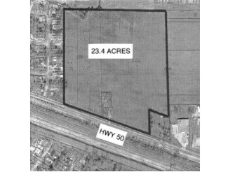
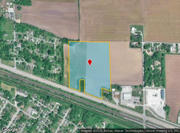
Property Record
Us 50, East Saint Louis, IL 62203
NEARBY LISTINGS FOR SALE OR LEASE
Property Detail
Us 50
St. Louis
Canteen Twp Sec 2
St. Louis, MO-IL
CANTEEN TWP SEC 23 LOT/SEC-23-SUBL/TWP-2N-BLK/RG-9W PT LT 13 PT SW N OF ST. & O FALLON RR A02125235
02-23.0-305-002
St. Clair
Agriculturalland
Illinois
2024
13
2024
20.06 AC
501300
Illinois
DEMOGRAPHICS near Us 50
1 Mile
3 Mile
5 Mile
2024 Total Population
3,865
27,233
75,669
2029 Population
3,928
27,549
75,614
Pop Growth 2024-2029
+ 1.63%
+ 1.16%
(0.07%)
Average Age
43
42
41
2024 Total Households
1,468
10,781
31,058
HH Growth 2024-2029
+ 1.84%
+ 1.20%
(0.06%)
Median Household Inc
$48,824
$50,203
$49,467
Avg Household Size
2.40
2.40
2.40
2024 Avg HH Vehicles
2.00
2.00
2.00
Median Home Value
$63,820
$78,820
$100,792
Median Year Built
1958
1959
1967
Nearby Places
- Restaurants
- Banks
- Shops
- Fitness
- Groceries
PUBLIC TRANSPORTATION
COMMUTER RAIL
Fairview Heights (Lambert Airport Shiloh-Scott - St. Louis MetroLink (MetroLink), Shrewsbury-Lansdowne I-44 Emerson Park - St. Louis MetroLink (MetroLink))
DRIVE
WALK
Distance
Fairview Heights (Lambert Airport Shiloh-Scott - St. Louis MetroLink (MetroLink), Shrewsbury-Lansdowne I-44 Emerson Park - St. Louis MetroLink (MetroLink))
4 min
2.1 mi
Washington Park (Lambert Airport Shiloh-Scott - St. Louis MetroLink (MetroLink), Shrewsbury-Lansdowne I-44 Emerson Park - St. Louis MetroLink (MetroLink))
DRIVE
WALK
Distance
Washington Park (Lambert Airport Shiloh-Scott - St. Louis MetroLink (MetroLink), Shrewsbury-Lansdowne I-44 Emerson Park - St. Louis MetroLink (MetroLink))
4 min
2.2 mi
AIRPORT
Scott AFB/Midamerica St Louis
DRIVE
WALK
Distance
Scott AFB/Midamerica St Louis
31 min
19.2 mi
St Louis Lambert International
DRIVE
WALK
Distance
St Louis Lambert International
32 min
21.3 mi
Freight Ports
Port Milwaukee
DRIVE
WALK
Distance
Port Milwaukee
415 min
366.0 mi
Nearby Properties
Address
Land Use
TOTAL SIZE
Lot Size
Zoning
Address
Land Use
TOTAL SIZE
Lot Size
Zoning
23.17 AC
Address
Land Use
TOTAL SIZE
Lot Size
Zoning
Address
Land Use
TOTAL SIZE
Lot Size
Zoning
20,154 SF
8.52 AC
Address
Land Use
TOTAL SIZE
Lot Size
Zoning
16,958 SF
24.53 AC
Address
Land Use
TOTAL SIZE
Lot Size
Zoning
40,320 SF
19.38 AC
Address
Land Use
TOTAL SIZE
Lot Size
Zoning
Address
Land Use
TOTAL SIZE
Lot Size
Zoning
37,472 SF
6.30 AC
Address
Land Use
TOTAL SIZE
Lot Size
Zoning
13,545 SF
2.75 AC
Address
Land Use
TOTAL SIZE
Lot Size
Zoning
12,464 SF
19.73 AC
Address
Land Use
TOTAL SIZE
Lot Size
Zoning
930 SF
7.27 AC
Address
Land Use
TOTAL SIZE
Lot Size
Zoning
16,637 SF
4.59 AC
Address
Land Use
TOTAL SIZE
Lot Size
Zoning
19.66 AC
Address
Land Use
TOTAL SIZE
Lot Size
Zoning
14.70 AC
Address
Land Use
TOTAL SIZE
Lot Size
Zoning
17,548 SF
2.36 AC
Address
Land Use
TOTAL SIZE
Lot Size
Zoning
Address
Land Use
TOTAL SIZE
Lot Size
Zoning
14,904 SF
23.66 AC
Address
Land Use
TOTAL SIZE
Lot Size
Zoning
34,289 SF
5.45 AC
Address
Land Use
TOTAL SIZE
Lot Size
Zoning
Address
Land Use
TOTAL SIZE
Lot Size
Zoning
6,801 SF
11.02 AC
Address
Land Use
TOTAL SIZE
Lot Size
Zoning
Address
Land Use
TOTAL SIZE
Lot Size
Zoning
21.99 AC
Address
Land Use
TOTAL SIZE
Lot Size
Zoning
8,800 SF
10.04 AC
Address
Land Use
TOTAL SIZE
Lot Size
Zoning
12,360 SF
1.66 AC
Address
Land Use
TOTAL SIZE
Lot Size
Zoning
Address
Land Use
TOTAL SIZE
Lot Size
Zoning
Address
Land Use
TOTAL SIZE
Lot Size
Zoning
12,672 SF
20.16 AC
Address
Land Use
TOTAL SIZE
Lot Size
Zoning
24.51 AC
Address
Land Use
TOTAL SIZE
Lot Size
Zoning
9,702 SF
4.96 AC
Address
Land Use
TOTAL SIZE
Lot Size
Zoning
Address
Land Use
TOTAL SIZE
Lot Size
Zoning
1,900 SF
8.27 AC
The World's #1 Commercial Real Estate Marketplace
Connect with us
© 2025 CoStar Group
The information above has been obtained from sources believed reliable. While we do not doubt its accuracy we have not verified it and make no guarantee, warranty or representation about it. It is your responsibility to independently confirm its accuracy and completeness. Any projections, opinions, assumptions, or estimates used are for example only and do not represent the current or future performance of the property. The value of this transaction to you depends on tax and other factors which should be evaluated by your tax, financial, and legal advisors. You and your advisors should conduct a careful, independent investigation of the property to determine to your satisfaction the suitability of the property for your needs.