Property Record
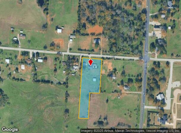
7301 Fishtrap Rd, Cross Roads, TX 76227
This Property Is For Sale
Property Detail
7301 Fishtrap Rd
Dallas-Fort Worth-Arlington, TX
R.J. Moseley
R38324
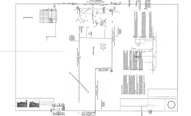
A0803A R.J. MOSELEY, TR 3, 2.694 ACRES, OLD DCAD TR 5B
Sfr
Denton
X
Texas
48121C0405G
3
2024
2.69 AC
2025
Outlying Denton County
020121
Dallas/Ft Worth
1,851 SF
NEARBY LISTINGS FOR SALE OR LEASE
-
-
-
65.8 Ac CORNER US-377 & Fishtrap Rd & FM-424
Cross Roads, TX 76227
Rent Upon Request
5 - 41.56 AC Lot
Land
-
-
-
-
-
-
-
-
-
-
-
-
-
-
-
-
-
-
-
-
-
-
-
View all Cross Roads listings for sale on LoopNet.com
DEMOGRAPHICS near 7301 Fishtrap Rd
1 mile
3 mile
5 mile
2024 Total Population
1,178
32,744
92,571
2029 Population
1,336
37,833
106,780
Pop Growth 2024-2029
+ 13.41%
+ 15.54%
+ 15.35%
Average Age
36
36
36
2024 Total Households
445
11,362
31,549
HH Growth 2024-2029
+ 13.48%
+ 16.01%
+ 15.80%
Median Household Inc
$94,699
$102,562
$111,737
Avg Household Size
2.70
2.90
2.90
2024 Avg HH Vehicles
2.00
2.00
2.00
Median Home Value
$478,999
$396,172
$424,716
Median Year Built
2011
2011
2010
Nearby Places
Map Layers
Map Styles
 Street
 Aerial
Transit
 Traffic
 Biking
Places
Listings with unknown addresses are not visible on the map
- Restaurants
- Banks
- Shops
- Fitness
- Groceries
PUBLIC TRANSPORTATION
COMMUTER RAIL
Downtown Denton Transit Center (A-train - Denton County Transportation Authority)
Drive
Walk
Distance
Downtown Denton Transit Center (A-train - Denton County Transportation Authority)
14 min
9.5 mi
Medpark Station (A-train - Denton County Transportation Authority)
Drive
Walk
Distance
Medpark Station (A-train - Denton County Transportation Authority)
17 min
9.9 mi
AIRPORT
Dallas-Fort Worth International
Drive
Walk
Distance
Dallas-Fort Worth International
43 min
30.1 mi
Dallas Love Field
Drive
Walk
Distance
Dallas Love Field
51 min
40.7 mi
Freight Ports
Port of Shreveport
Drive
Walk
Distance
Port of Shreveport
255 min
234.1 mi
Nearby Properties
Address
Land Use
TOTAL SIZE
Lot Size
Zoning
Address
Land Use
TOTAL SIZE
Lot Size
Zoning
500,000 SF
57.47 AC
Address
Land Use
TOTAL SIZE
Lot Size
Zoning
353,927 SF
16.85 AC
Address
Land Use
TOTAL SIZE
Lot Size
Zoning
400,512 SF
19.54 AC
Address
Land Use
TOTAL SIZE
Lot Size
Zoning
351,112 SF
12.65 AC
Address
Land Use
TOTAL SIZE
Lot Size
Zoning
259,524 SF
10 AC
Address
Land Use
TOTAL SIZE
Lot Size
Zoning
181,674 SF
49.62 AC
Address
Land Use
TOTAL SIZE
Lot Size
Zoning
91,745 SF
15.10 AC
Address
Land Use
TOTAL SIZE
Lot Size
Zoning
91,438 SF
13.06 AC
Address
Land Use
TOTAL SIZE
Lot Size
Zoning
422 SF
75.90 AC
Address
Land Use
TOTAL SIZE
Lot Size
Zoning
149,408 SF
11.11 AC
Address
Land Use
TOTAL SIZE
Lot Size
Zoning
79,700 SF
14.54 AC
Address
Land Use
TOTAL SIZE
Lot Size
Zoning
32.84 AC
Address
Land Use
TOTAL SIZE
Lot Size
Zoning
26,586 SF
44.87 AC
Address
Land Use
TOTAL SIZE
Lot Size
Zoning
142,919 SF
9.46 AC
Address
Land Use
TOTAL SIZE
Lot Size
Zoning
83,752 SF
10.43 AC
Address
Land Use
TOTAL SIZE
Lot Size
Zoning
30.35 AC
Address
Land Use
TOTAL SIZE
Lot Size
Zoning
183,441 SF
22.38 AC
Address
Land Use
TOTAL SIZE
Lot Size
Zoning
58,500 SF
6.11 AC
Address
Land Use
TOTAL SIZE
Lot Size
Zoning
103,030 SF
5.32 AC
Address
Land Use
TOTAL SIZE
Lot Size
Zoning
152.52 AC
Address
Land Use
TOTAL SIZE
Lot Size
Zoning
24,350 SF
2.92 AC
Address
Land Use
TOTAL SIZE
Lot Size
Zoning
30,340 SF
9.27 AC
Address
Land Use
TOTAL SIZE
Lot Size
Zoning
36,577 SF
28.87 AC
Address
Land Use
TOTAL SIZE
Lot Size
Zoning
9.93 AC
Address
Land Use
TOTAL SIZE
Lot Size
Zoning
17.35 AC
Address
Land Use
TOTAL SIZE
Lot Size
Zoning
12.20 AC
Address
Land Use
TOTAL SIZE
Lot Size
Zoning
9.18 AC
Address
Land Use
TOTAL SIZE
Lot Size
Zoning
22,196 SF
3.44 AC
Address
Land Use
TOTAL SIZE
Lot Size
Zoning
182,174 SF
19.81 AC
Address
Land Use
TOTAL SIZE
Lot Size
Zoning
82,415 SF
5.30 AC
The World's #1 Commercial Real Estate Marketplace
Connect with us
© 2026 CoStar Group
The information above has been obtained from sources believed reliable. While we do not doubt its accuracy we have not verified it and make no guarantee, warranty or representation about it. It is your responsibility to independently confirm its accuracy and completeness. Any projections, opinions, assumptions, or estimates used are for example only and do not represent the current or future performance of the property. The value of this transaction to you depends on tax and other factors which should be evaluated by your tax, financial, and legal advisors. You and your advisors should conduct a careful, independent investigation of the property to determine to your satisfaction the suitability of the property for your needs.