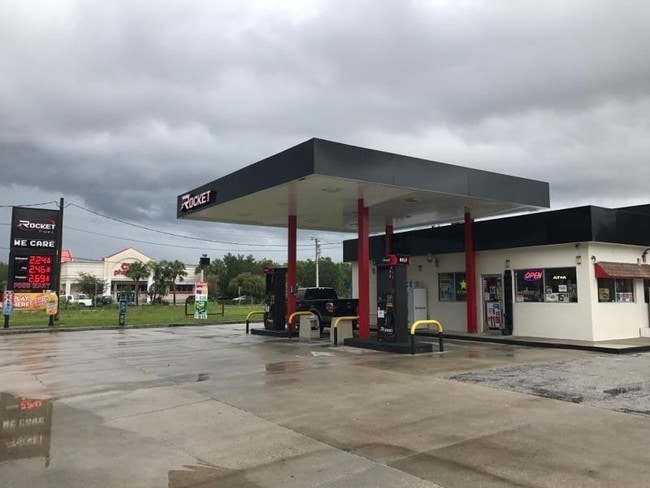
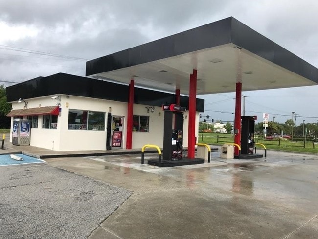
Property Record
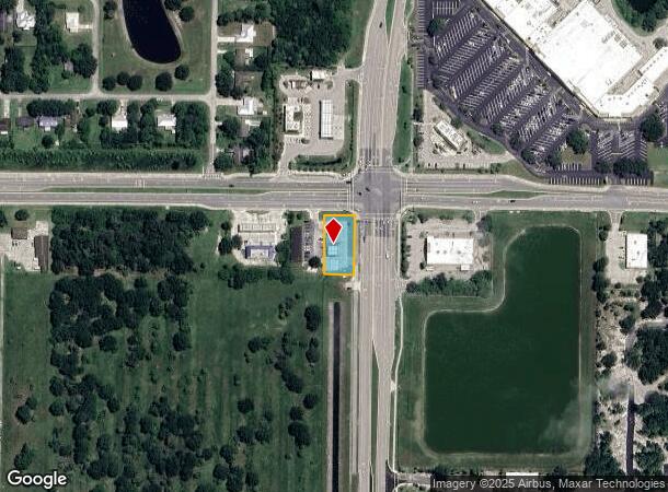
7301 Indrio Rd, Fort Pierce, FL 34951

NEARBY LISTINGS FOR SALE OR LEASE
Property Detail
7301 Indrio Rd
13-14-411-0001-0006
Metes And Bounds
Servicestation
14 34 39 S 200 FT OF N 220 FT OF W 100 FT OF E 180 FT OF S 1/2 (0.46 AC) (OR 3880-2581)
X
St Lucie
12061C0370H
Florida
2024
0.46 AC
2025
Fort Pierce
382201
Port St Lucie/Fort Pierce
3,001 SF
Port St Lucie, FL
DEMOGRAPHICS near 7301 Indrio Rd
1 Mile
3 Mile
5 Mile
2024 Total Population
3,583
17,186
49,296
2029 Population
4,349
20,505
57,645
Pop Growth 2024-2029
+ 21.38%
+ 19.31%
+ 16.94%
Average Age
40
45
44
2024 Total Households
1,419
7,044
19,325
HH Growth 2024-2029
+ 20.86%
+ 18.99%
+ 16.63%
Median Household Inc
$54,017
$53,921
$51,117
Avg Household Size
2.50
2.40
2.40
2024 Avg HH Vehicles
2.00
2.00
2.00
Median Home Value
$191,904
$182,263
$187,178
Median Year Built
1984
1986
1988
Nearby Places
Map Layers
Map Styles
 Street
 Aerial
- Restaurants
- Banks
- Shops
- Fitness
- Groceries
Nearby Properties
Address
Land Use
TOTAL SIZE
Lot Size
Zoning
Address
Land Use
TOTAL SIZE
Lot Size
Zoning
147,175 SF
56.96 AC
RS-2 - COU
Address
Land Use
TOTAL SIZE
Lot Size
Zoning
132,572 SF
17.39 AC
COMM GENRA
Address
Land Use
TOTAL SIZE
Lot Size
Zoning
76,130 SF
13.71 AC
INDUSTRIAL
Address
Land Use
TOTAL SIZE
Lot Size
Zoning
113,758 SF
219.88 AC
UTILITIES
Address
Land Use
TOTAL SIZE
Lot Size
Zoning
37,090 SF
35.84 AC
PLANNED MX
Address
Land Use
TOTAL SIZE
Lot Size
Zoning
57,024 SF
10.45 AC
RM-9 COUNT
Address
Land Use
TOTAL SIZE
Lot Size
Zoning
924 SF
30.87 AC
RS-6
Address
Land Use
TOTAL SIZE
Lot Size
Zoning
87,207 SF
17.16 AC
INSTITUTIO
Address
Land Use
TOTAL SIZE
Lot Size
Zoning
17,513 SF
325.01 AC
CONSERVATI
Address
Land Use
TOTAL SIZE
Lot Size
Zoning
242.35 AC
UTILITIES
Address
Land Use
TOTAL SIZE
Lot Size
Zoning
37,280 SF
14 AC
INDUSTRIAL
Address
Land Use
TOTAL SIZE
Lot Size
Zoning
105.13 AC
CONSERVATI
Address
Land Use
TOTAL SIZE
Lot Size
Zoning
160.93 AC
INDUSTRIAL
Address
Land Use
TOTAL SIZE
Lot Size
Zoning
50,635 SF
3.48 AC
COMM GENRA
Address
Land Use
TOTAL SIZE
Lot Size
Zoning
1,436 SF
157.05 AC
UTILITIES
Address
Land Use
TOTAL SIZE
Lot Size
Zoning
69,332 SF
11.61 AC
INDUSTRIAL
Address
Land Use
TOTAL SIZE
Lot Size
Zoning
25,920 SF
3.21 AC
INDUSTRIAL
Address
Land Use
TOTAL SIZE
Lot Size
Zoning
11,200 SF
1.72 AC
COMM GENRA
Address
Land Use
TOTAL SIZE
Lot Size
Zoning
14,960 SF
54.15 AC
INDUSTRIAL
Address
Land Use
TOTAL SIZE
Lot Size
Zoning
71.49 AC
INDUSTRIAL
Address
Land Use
TOTAL SIZE
Lot Size
Zoning
117.17 AC
UTILITIES
Address
Land Use
TOTAL SIZE
Lot Size
Zoning
48,010 SF
11.02 AC
UTILITIES
Address
Land Use
TOTAL SIZE
Lot Size
Zoning
10.09 AC
PLANNED RE
Address
Land Use
TOTAL SIZE
Lot Size
Zoning
45,876 SF
19.50 AC
PLANNED MX
Address
Land Use
TOTAL SIZE
Lot Size
Zoning
5,151 SF
36.87 AC
INSTITUTIO
Address
Land Use
TOTAL SIZE
Lot Size
Zoning
760 SF
79.55 AC
RS-6
Address
Land Use
TOTAL SIZE
Lot Size
Zoning
29.24 AC
INDUSTRIAL
Address
Land Use
TOTAL SIZE
Lot Size
Zoning
43.22 AC
PLANNED MX
Address
Land Use
TOTAL SIZE
Lot Size
Zoning
7.01 AC
ROW
Address
Land Use
TOTAL SIZE
Lot Size
Zoning
35.43 AC
PLANNED RE
The World's #1 Commercial Real Estate Marketplace
Connect with us
© 2026 CoStar Group
The information above has been obtained from sources believed reliable. While we do not doubt its accuracy we have not verified it and make no guarantee, warranty or representation about it. It is your responsibility to independently confirm its accuracy and completeness. Any projections, opinions, assumptions, or estimates used are for example only and do not represent the current or future performance of the property. The value of this transaction to you depends on tax and other factors which should be evaluated by your tax, financial, and legal advisors. You and your advisors should conduct a careful, independent investigation of the property to determine to your satisfaction the suitability of the property for your needs.