Property Record
7301 N Owasso Expy E, Owasso, OK 74055
Current Lease Availabilities
NEARBY LISTINGS FOR SALE OR LEASE
Property Detail
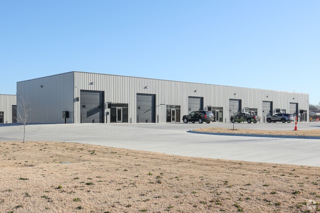
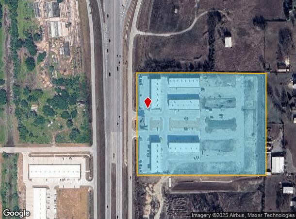
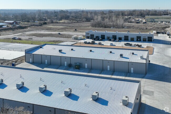
7301 N Owasso Expy E
Tulsa
Helscel-Huneryager Industrial Park
Tulsa, OK
LOT 1 BLOCK 1
61104-14-32-29400
Tulsa
Lightindustrial
Oklahoma
2025
1
2025
12.69 AC
005805
Northeast Tulsa
48,000 SF
DEMOGRAPHICS near 7301 N Owasso Expy E
1 Mile
3 Mile
5 Mile
2024 Total Population
4,838
30,043
50,905
2029 Population
4,973
31,169
53,332
Pop Growth 2024-2029
+ 2.79%
+ 3.75%
+ 4.77%
Average Age
39
38
38
2024 Total Households
1,957
11,406
18,868
HH Growth 2024-2029
+ 2.81%
+ 3.73%
+ 4.71%
Median Household Inc
$53,453
$72,358
$79,516
Avg Household Size
2.40
2.60
2.70
2024 Avg HH Vehicles
2.00
2.00
2.00
Median Home Value
$166,950
$227,132
$226,394
Median Year Built
1982
1996
1999
Nearby Places
Map Layers
Map Styles
 Street
 Aerial
- Restaurants
- Banks
- Shops
- Fitness
- Groceries
PUBLIC TRANSPORTATION
AIRPORT
Tulsa International
DRIVE
WALK
Distance
Tulsa International
12 min
7.1 mi
Freight Ports
Tulsa Port Of Catoosa
DRIVE
WALK
Distance
Tulsa Port Of Catoosa
14 min
10.0 mi
Nearby Properties
Address
Land Use
TOTAL SIZE
Lot Size
Zoning
Address
Land Use
TOTAL SIZE
Lot Size
Zoning
3,235,512 SF
71.56 AC
IM
Address
Land Use
TOTAL SIZE
Lot Size
Zoning
111,792 SF
12.43 AC
OM
Address
Land Use
TOTAL SIZE
Lot Size
Zoning
209,620 SF
19.59 AC
IM
Address
Land Use
TOTAL SIZE
Lot Size
Zoning
65,354 SF
41.54 AC
AG
Address
Land Use
TOTAL SIZE
Lot Size
Zoning
115,952 SF
19.30 AC
RS3
Address
Land Use
TOTAL SIZE
Lot Size
Zoning
138,427 SF
8.90 AC
OM
Address
Land Use
TOTAL SIZE
Lot Size
Zoning
105,098 SF
18.22 AC
RS2
Address
Land Use
TOTAL SIZE
Lot Size
Zoning
64,520 SF
34.28 AC
NCU
Address
Land Use
TOTAL SIZE
Lot Size
Zoning
93,712 SF
14.01 AC
RM1
Address
Land Use
TOTAL SIZE
Lot Size
Zoning
91,189 SF
10.24 AC
AG
Address
Land Use
TOTAL SIZE
Lot Size
Zoning
34,066 SF
2.88 AC
CH
Address
Land Use
TOTAL SIZE
Lot Size
Zoning
78,464 SF
10.21 AC
AG
Address
Land Use
TOTAL SIZE
Lot Size
Zoning
270,386 SF
14.65 AC
RM
Address
Land Use
TOTAL SIZE
Lot Size
Zoning
31,502 SF
11.08 AC
AG
Address
Land Use
TOTAL SIZE
Lot Size
Zoning
43,252 SF
7.86 AC
RS3
Address
Land Use
TOTAL SIZE
Lot Size
Zoning
2,112 SF
10.89 AC
Address
Land Use
TOTAL SIZE
Lot Size
Zoning
266,778 SF
12.26 AC
CN
Address
Land Use
TOTAL SIZE
Lot Size
Zoning
17,600 SF
15.04 AC
RE
Address
Land Use
TOTAL SIZE
Lot Size
Zoning
24,679 SF
46.96 AC
IM
Address
Land Use
TOTAL SIZE
Lot Size
Zoning
307,768 SF
31.31 AC
RM1
Address
Land Use
TOTAL SIZE
Lot Size
Zoning
133,467 SF
11.37 AC
CS
Address
Land Use
TOTAL SIZE
Lot Size
Zoning
101,776 SF
9.96 AC
CS
Address
Land Use
TOTAL SIZE
Lot Size
Zoning
38,608 SF
5.07 AC
RS1
Address
Land Use
TOTAL SIZE
Lot Size
Zoning
49,541 SF
5.28 AC
AG
Address
Land Use
TOTAL SIZE
Lot Size
Zoning
29,140 SF
2.75 AC
CH
Address
Land Use
TOTAL SIZE
Lot Size
Zoning
71,898 SF
3.66 AC
CS
Address
Land Use
TOTAL SIZE
Lot Size
Zoning
42,983 SF
3.41 AC
RS3
Address
Land Use
TOTAL SIZE
Lot Size
Zoning
178,815 SF
18.21 AC
CS
Address
Land Use
TOTAL SIZE
Lot Size
Zoning
8,543 SF
1.24 AC
CS
Address
Land Use
TOTAL SIZE
Lot Size
Zoning
24,907 SF
27.83 AC
IL
The World's #1 Commercial Real Estate Marketplace
Connect with us
© 2025 CoStar Group
The information above has been obtained from sources believed reliable. While we do not doubt its accuracy we have not verified it and make no guarantee, warranty or representation about it. It is your responsibility to independently confirm its accuracy and completeness. Any projections, opinions, assumptions, or estimates used are for example only and do not represent the current or future performance of the property. The value of this transaction to you depends on tax and other factors which should be evaluated by your tax, financial, and legal advisors. You and your advisors should conduct a careful, independent investigation of the property to determine to your satisfaction the suitability of the property for your needs.