Property Record
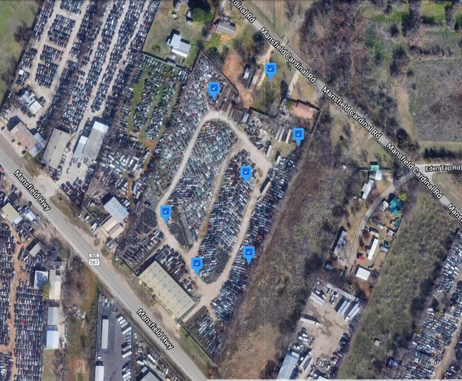
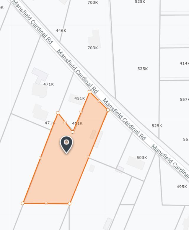
7302 Mansfield Cardinal Rd, Kennedale, TX 76060
NEARBY LISTINGS FOR SALE OR LEASE
Property Detail
7302 Mansfield Cardinal Rd
04476816
Russell, Jesse Survey
Commercialnec
RUSSELL, JESSE SURVEY ABSTRACT 1361 TRACT 13F02
X
Tarrant
48439C0340K
Texas
2023
2.24 AC
2025
Arlington/Mansfield
111408
Dallas/Ft Worth
16,000 SF
Dallas-Fort Worth-Arlington, TX
DEMOGRAPHICS near 7302 Mansfield Cardinal Rd
1 Mile
3 Mile
5 Mile
2024 Total Population
2,436
52,020
172,882
2029 Population
2,643
54,989
181,974
Pop Growth 2024-2029
+ 8.50%
+ 5.71%
+ 5.26%
Average Age
40
39
39
2024 Total Households
848
19,016
60,176
HH Growth 2024-2029
+ 8.61%
+ 5.71%
+ 5.29%
Median Household Inc
$97,891
$87,548
$83,167
Avg Household Size
2.80
2.70
2.80
2024 Avg HH Vehicles
2.00
2.00
2.00
Median Home Value
$364,977
$314,451
$277,714
Median Year Built
2007
1991
1990
Nearby Places
Map Layers
Map Styles
 Street
 Aerial
- Restaurants
- Banks
- Shops
- Fitness
- Groceries
PUBLIC TRANSPORTATION
AIRPORT
Dallas-Fort Worth International
DRIVE
WALK
Distance
Dallas-Fort Worth International
43 min
28.9 mi
Dallas Love Field
DRIVE
WALK
Distance
Dallas Love Field
52 min
37.5 mi
Freight Ports
Port of Shreveport
DRIVE
WALK
Distance
Port of Shreveport
243 min
223.2 mi
Nearby Properties
Address
Land Use
TOTAL SIZE
Lot Size
Zoning
Address
Land Use
TOTAL SIZE
Lot Size
Zoning
170,082 SF
36.49 AC
Address
Land Use
TOTAL SIZE
Lot Size
Zoning
214,444 SF
17.45 AC
Address
Land Use
TOTAL SIZE
Lot Size
Zoning
167,643 SF
8.99 AC
Address
Land Use
TOTAL SIZE
Lot Size
Zoning
186,894 SF
10.85 AC
Address
Land Use
TOTAL SIZE
Lot Size
Zoning
169,347 SF
13.92 AC
Address
Land Use
TOTAL SIZE
Lot Size
Zoning
222,500 SF
13.86 AC
Address
Land Use
TOTAL SIZE
Lot Size
Zoning
180,556 SF
11.78 AC
Address
Land Use
TOTAL SIZE
Lot Size
Zoning
147,822 SF
9.45 AC
Address
Land Use
TOTAL SIZE
Lot Size
Zoning
301,302 SF
0.46 AC
Address
Land Use
TOTAL SIZE
Lot Size
Zoning
193,290 SF
10.56 AC
Address
Land Use
TOTAL SIZE
Lot Size
Zoning
217,786 SF
39.04 AC
Address
Land Use
TOTAL SIZE
Lot Size
Zoning
159,030 SF
10.32 AC
Address
Land Use
TOTAL SIZE
Lot Size
Zoning
268,603 SF
12.45 AC
Address
Land Use
TOTAL SIZE
Lot Size
Zoning
238,119 SF
7.52 AC
Address
Land Use
TOTAL SIZE
Lot Size
Zoning
142,110 SF
7.40 AC
Address
Land Use
TOTAL SIZE
Lot Size
Zoning
119,741 SF
45 AC
Address
Land Use
TOTAL SIZE
Lot Size
Zoning
81,540 SF
11.89 AC
Address
Land Use
TOTAL SIZE
Lot Size
Zoning
80,907 SF
29 AC
Address
Land Use
TOTAL SIZE
Lot Size
Zoning
44,669 SF
9.05 AC
Address
Land Use
TOTAL SIZE
Lot Size
Zoning
143,104 SF
7.75 AC
Address
Land Use
TOTAL SIZE
Lot Size
Zoning
77,884 SF
30.70 AC
Address
Land Use
TOTAL SIZE
Lot Size
Zoning
127,690 SF
37.21 AC
Address
Land Use
TOTAL SIZE
Lot Size
Zoning
156,103 SF
4.42 AC
Address
Land Use
TOTAL SIZE
Lot Size
Zoning
41,960 SF
13.70 AC
Address
Land Use
TOTAL SIZE
Lot Size
Zoning
64,903 SF
2.64 AC
Address
Land Use
TOTAL SIZE
Lot Size
Zoning
210,939 SF
18.35 AC
Address
Land Use
TOTAL SIZE
Lot Size
Zoning
110,621 SF
12.27 AC
Address
Land Use
TOTAL SIZE
Lot Size
Zoning
108,708 SF
16.64 AC
Address
Land Use
TOTAL SIZE
Lot Size
Zoning
112,110 SF
14.64 AC
Address
Land Use
TOTAL SIZE
Lot Size
Zoning
79,380 SF
12.90 AC
The World's #1 Commercial Real Estate Marketplace
Connect with us
© 2026 CoStar Group
The information above has been obtained from sources believed reliable. While we do not doubt its accuracy we have not verified it and make no guarantee, warranty or representation about it. It is your responsibility to independently confirm its accuracy and completeness. Any projections, opinions, assumptions, or estimates used are for example only and do not represent the current or future performance of the property. The value of this transaction to you depends on tax and other factors which should be evaluated by your tax, financial, and legal advisors. You and your advisors should conduct a careful, independent investigation of the property to determine to your satisfaction the suitability of the property for your needs.