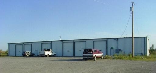
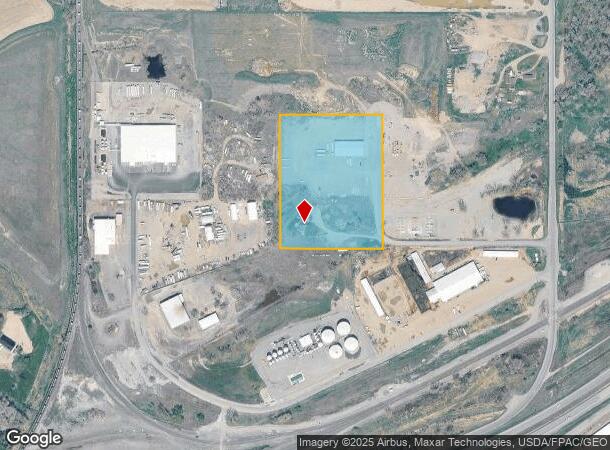
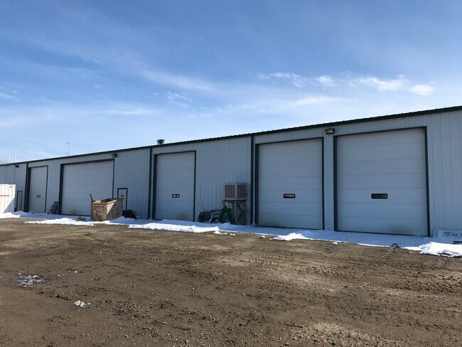
Property Record
7302 Racheal Rd, Billings, MT 59106

NEARBY LISTINGS FOR SALE OR LEASE
Property Detail
7302 Racheal Rd
Billings, MT
Mossmain Subd
03-0821-01-4-70-01-0000
MOSSMAIN SUBD, S01, T02 S, R24 E, BLOCK 1, LOT 2, (99)
Commercialnec
Yellowstone
X
Montana
30111C1430E
2
2024
9.41 AC
2025
Billings
001403
Other Market Areas
12,800 SF
DEMOGRAPHICS near 7302 Racheal Rd
1 Mile
3 Mile
5 Mile
2024 Total Population
254
4,460
15,166
2029 Population
271
4,811
16,380
Pop Growth 2024-2029
+ 6.69%
+ 7.87%
+ 8.00%
Average Age
41
39
40
2024 Total Households
88
1,684
5,936
HH Growth 2024-2029
+ 6.82%
+ 8.14%
+ 8.22%
Median Household Inc
$132,812
$82,049
$81,293
Avg Household Size
2.80
2.60
2.50
2024 Avg HH Vehicles
3.00
3.00
2.00
Median Home Value
$434,482
$357,644
$318,296
Median Year Built
1995
1989
1983
Nearby Places
Map Layers
Map Styles
 Street
 Aerial
- Restaurants
- Banks
- Shops
- Fitness
- Groceries
PUBLIC TRANSPORTATION
AIRPORT
Billings Logan International
DRIVE
WALK
Distance
Billings Logan International
37 min
17.3 mi
Freight Ports
Port of Everett
DRIVE
WALK
Distance
Port of Everett
870 min
830.0 mi
SALE & LEASE HISTORY
LISTING DATE
SALE/LEASE

Apr 20, 2022
For Lease
Nearby Properties
Address
Land Use
TOTAL SIZE
Lot Size
Zoning
Address
Land Use
TOTAL SIZE
Lot Size
Zoning
158,130 SF
16.11 AC
Address
Land Use
TOTAL SIZE
Lot Size
Zoning
86,116 SF
12.07 AC
1
Address
Land Use
TOTAL SIZE
Lot Size
Zoning
44,280 SF
4.90 AC
1
Address
Land Use
TOTAL SIZE
Lot Size
Zoning
39,379 SF
3.90 AC
Address
Land Use
TOTAL SIZE
Lot Size
Zoning
4,560 SF
12.57 AC
Address
Land Use
TOTAL SIZE
Lot Size
Zoning
142,080 SF
10.02 AC
Address
Land Use
TOTAL SIZE
Lot Size
Zoning
91,830 SF
7.81 AC
Address
Land Use
TOTAL SIZE
Lot Size
Zoning
63,360 SF
2.96 AC
Address
Land Use
TOTAL SIZE
Lot Size
Zoning
62,000 SF
21.59 AC
7
Address
Land Use
TOTAL SIZE
Lot Size
Zoning
11,925 SF
65 AC
Address
Land Use
TOTAL SIZE
Lot Size
Zoning
12,311 SF
4 AC
8
Address
Land Use
TOTAL SIZE
Lot Size
Zoning
33,200 SF
5 AC
Address
Land Use
TOTAL SIZE
Lot Size
Zoning
44,600 SF
7.11 AC
Address
Land Use
TOTAL SIZE
Lot Size
Zoning
3,578 SF
77.36 AC
Address
Land Use
TOTAL SIZE
Lot Size
Zoning
34,120 SF
7.63 AC
Address
Land Use
TOTAL SIZE
Lot Size
Zoning
17,112 SF
38.63 AC
Address
Land Use
TOTAL SIZE
Lot Size
Zoning
6.99 AC
1
Address
Land Use
TOTAL SIZE
Lot Size
Zoning
50,600 SF
4.72 AC
HC
Address
Land Use
TOTAL SIZE
Lot Size
Zoning
16,104 SF
12.11 AC
Address
Land Use
TOTAL SIZE
Lot Size
Zoning
11,163 SF
7.64 AC
6
Address
Land Use
TOTAL SIZE
Lot Size
Zoning
30,072 SF
10 AC
Address
Land Use
TOTAL SIZE
Lot Size
Zoning
10 AC
HC
Address
Land Use
TOTAL SIZE
Lot Size
Zoning
31,800 SF
10 AC
Address
Land Use
TOTAL SIZE
Lot Size
Zoning
8,250 SF
10 AC
Address
Land Use
TOTAL SIZE
Lot Size
Zoning
21,260 SF
8.41 AC
Address
Land Use
TOTAL SIZE
Lot Size
Zoning
12,412 SF
3.20 AC
Address
Land Use
TOTAL SIZE
Lot Size
Zoning
8,930 SF
5.39 AC
Address
Land Use
TOTAL SIZE
Lot Size
Zoning
14,276 SF
10.04 AC
Address
Land Use
TOTAL SIZE
Lot Size
Zoning
16,080 SF
2.36 AC
The World's #1 Commercial Real Estate Marketplace
Connect with us
© 2026 CoStar Group
The information above has been obtained from sources believed reliable. While we do not doubt its accuracy we have not verified it and make no guarantee, warranty or representation about it. It is your responsibility to independently confirm its accuracy and completeness. Any projections, opinions, assumptions, or estimates used are for example only and do not represent the current or future performance of the property. The value of this transaction to you depends on tax and other factors which should be evaluated by your tax, financial, and legal advisors. You and your advisors should conduct a careful, independent investigation of the property to determine to your satisfaction the suitability of the property for your needs.