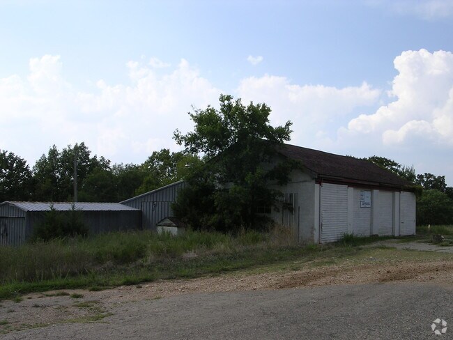
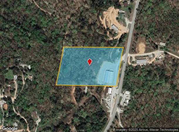
Property Record
7305 State Highway 13, Lampe, MO 65681
NEARBY LISTINGS FOR SALE OR LEASE
-
-
View all Lampe listings for sale on LoopNet.com
Property Detail
7305 State Highway 13
14-8.0-33-000-000-006.000
BEG 417.42 FT S OF N LINE OF SE NW AT A PT ON W R/W LINE OF HWY 13, NERLY FOLLOWING W LINE HWY 13 TO N LINE OF SE NW, DUE W 624 FT, SWRLY PARALLEL TO HWY 13, 417.42 FT, E 624 FT TO BEG; BEG AT A PT ON W R/W LINE OF HWY 13, SD PT BEING S 417.42 FT OF
Storemultistory
Stone
X
Missouri
29209C0260D
6.08 AC
2024
Branson
2025
Other Market Areas
090401
Branson, MO
10,000 SF
DEMOGRAPHICS near 7305 State Highway 13
1 Mile
3 Mile
5 Mile
2024 Total Population
137
2,433
7,750
2029 Population
152
2,707
8,599
Pop Growth 2024-2029
+ 10.95%
+ 11.26%
+ 10.95%
Average Age
53
53
54
2024 Total Households
65
1,141
3,603
HH Growth 2024-2029
+ 10.77%
+ 10.52%
+ 10.27%
Median Household Inc
$52,143
$55,000
$57,491
Avg Household Size
2.10
2.10
2.10
2024 Avg HH Vehicles
2.00
2.00
2.00
Median Home Value
$189,999
$212,451
$240,025
Median Year Built
1985
1988
1989
Nearby Places
Map Layers
Map Styles
 Street
 Aerial
- Restaurants
- Banks
- Shops
- Fitness
- Groceries
Nearby Properties
Address
Land Use
TOTAL SIZE
Lot Size
Zoning
Address
Land Use
TOTAL SIZE
Lot Size
Zoning
1,500 SF
26 AC
A-1
Address
Land Use
TOTAL SIZE
Lot Size
Zoning
20,274 SF
57.80 AC
C-2
Address
Land Use
TOTAL SIZE
Lot Size
Zoning
9,363 SF
25.87 AC
C-2
Address
Land Use
TOTAL SIZE
Lot Size
Zoning
1,560 SF
0.01 AC
R-3
Address
Land Use
TOTAL SIZE
Lot Size
Zoning
23,550 SF
4.30 AC
C-2
Address
Land Use
TOTAL SIZE
Lot Size
Zoning
2,184 SF
4.63 AC
C-2
Address
Land Use
TOTAL SIZE
Lot Size
Zoning
1,760 SF
3.50 AC
C-2
Address
Land Use
TOTAL SIZE
Lot Size
Zoning
0.13 AC
A-1
Address
Land Use
TOTAL SIZE
Lot Size
Zoning
Address
Land Use
TOTAL SIZE
Lot Size
Zoning
3,512 SF
0.82 AC
RR-1
Address
Land Use
TOTAL SIZE
Lot Size
Zoning
5,839 SF
47.76 AC
A-1
Address
Land Use
TOTAL SIZE
Lot Size
Zoning
10,353 SF
0.27 AC
C-2
Address
Land Use
TOTAL SIZE
Lot Size
Zoning
3,285 SF
4.20 AC
C-2
Address
Land Use
TOTAL SIZE
Lot Size
Zoning
5,200 SF
18.18 AC
A-1
Address
Land Use
TOTAL SIZE
Lot Size
Zoning
3,614 SF
3.05 AC
RR-1
Address
Land Use
TOTAL SIZE
Lot Size
Zoning
1,008 SF
13.75 AC
RR-1
Address
Land Use
TOTAL SIZE
Lot Size
Zoning
2,920 SF
2.50 AC
C-2
Address
Land Use
TOTAL SIZE
Lot Size
Zoning
6,348 SF
2.75 AC
C-2
Address
Land Use
TOTAL SIZE
Lot Size
Zoning
3,000 SF
0.40 AC
C-2
Address
Land Use
TOTAL SIZE
Lot Size
Zoning
4,000 SF
6.70 AC
C-2
Address
Land Use
TOTAL SIZE
Lot Size
Zoning
3,500 SF
0.34 AC
C-2
Address
Land Use
TOTAL SIZE
Lot Size
Zoning
1,500 SF
5.53 AC
RR-1
Address
Land Use
TOTAL SIZE
Lot Size
Zoning
0.07 AC
R-1
Address
Land Use
TOTAL SIZE
Lot Size
Zoning
4,000 SF
2.02 AC
C-2
Address
Land Use
TOTAL SIZE
Lot Size
Zoning
2,400 SF
0.47 AC
C-2
Address
Land Use
TOTAL SIZE
Lot Size
Zoning
360 SF
0.30 AC
RR-1
Address
Land Use
TOTAL SIZE
Lot Size
Zoning
4,220 SF
2.90 AC
C-2
Address
Land Use
TOTAL SIZE
Lot Size
Zoning
5,000 SF
2 AC
RR-1
Address
Land Use
TOTAL SIZE
Lot Size
Zoning
2,240 SF
1.01 AC
C-2
The World's #1 Commercial Real Estate Marketplace
Connect with us
© 2026 CoStar Group
The information above has been obtained from sources believed reliable. While we do not doubt its accuracy we have not verified it and make no guarantee, warranty or representation about it. It is your responsibility to independently confirm its accuracy and completeness. Any projections, opinions, assumptions, or estimates used are for example only and do not represent the current or future performance of the property. The value of this transaction to you depends on tax and other factors which should be evaluated by your tax, financial, and legal advisors. You and your advisors should conduct a careful, independent investigation of the property to determine to your satisfaction the suitability of the property for your needs.