Property Record
7307 N Main St, Jacksonville, FL 32208

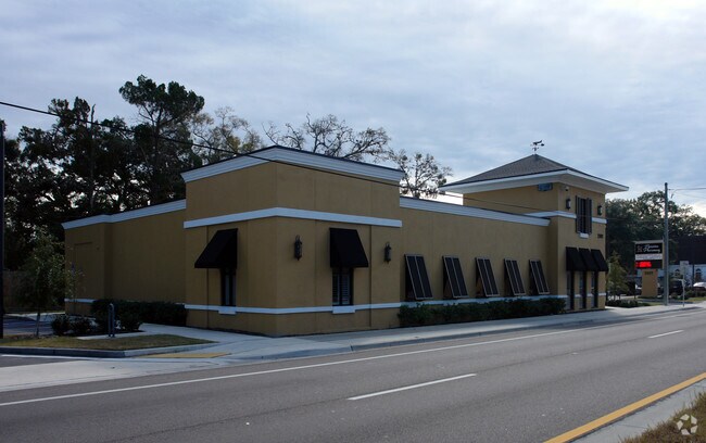

Property Detail
7307 N Main St
033972-0000
3-76 25-1S-26E .762 REPLAT LOTS 41 TO 46 PANAMA PARK S1/2 LOT 7, LOTS 10,11,14,15,18,19 BLK 10 (EX PT R/W)
Medicalbuilding
Duval
CCG-2
Florida
B and X Area of moderate flood hazard, usually the area between the limits of the 100-year and 500-year floods.
41
2025
0.75 AC
2026
Downtown Northbank
000102
Jacksonville (Florida)
5,571 SF
Jacksonville, FL
NEARBY LISTINGS FOR SALE OR LEASE
DEMOGRAPHICS near 7307 N Main St
1 mile
3 mile
5 mile
2025 Total Population
7,548
66,401
185,756
2030 Population
8,111
71,544
198,389
Pop Growth 2025-2030
+ 7.46%
+ 7.75%
+ 6.80%
Average Age
40
38
39
2025 Total Households
3,116
26,600
73,474
HH Growth 2025-2030
+ 7.77%
+ 8.04%
+ 7.22%
Median Household Inc
$38,263
$38,452
$43,939
Avg Household Size
2.40
2.40
2.40
2025 Avg HH Vehicles
1.00
1.00
1.00
Median Home Value
$133,402
$168,553
$197,901
Median Year Built
1955
1964
1968
Nearby Places
Map Layers
Map Styles
 Street
 Aerial
Layers
 Traffic
 Biking
Places
Listings with unknown addresses are not visible on the map
- Restaurants
- Banks
- Shops
- Fitness
- Groceries
PUBLIC TRANSPORTATION
COMMUTER RAIL
Jacksonville (Silver Meteor - Amtrak, Silver Star - Amtrak)
Drive
Walk
Distance
Jacksonville (Silver Meteor - Amtrak, Silver Star - Amtrak)
14 min
6.9 mi
AIRPORT
Jacksonville International
Drive
Walk
Distance
Jacksonville International
18 min
10.6 mi
Freight Ports
Jacksonville Port
Drive
Walk
Distance
Jacksonville Port
8 min
3.2 mi
Nearby Properties
Address
Land Use
TOTAL SIZE
Lot Size
Zoning
Address
Land Use
TOTAL SIZE
Lot Size
Zoning
705,940 SF
25.12 AC
PBF-1
Address
Land Use
TOTAL SIZE
Lot Size
Zoning
1,064,086 SF
87.81 AC
IL
Address
Land Use
TOTAL SIZE
Lot Size
Zoning
1,010,874 SF
62.96 AC
PUD
Address
Land Use
TOTAL SIZE
Lot Size
Zoning
336,852 SF
32.69 AC
IL
Address
Land Use
TOTAL SIZE
Lot Size
Zoning
823,286 SF
53.36 AC
IL
Address
Land Use
TOTAL SIZE
Lot Size
Zoning
1,678,675 SF
73.48 AC
IL
Address
Land Use
TOTAL SIZE
Lot Size
Zoning
588,053 SF
33.10 AC
PUD
Address
Land Use
TOTAL SIZE
Lot Size
Zoning
488,100 SF
35.32 AC
CRO
Address
Land Use
TOTAL SIZE
Lot Size
Zoning
163,471 SF
7.85 AC
PBF-2
Address
Land Use
TOTAL SIZE
Lot Size
Zoning
740,260 SF
59.11 AC
IL
Address
Land Use
TOTAL SIZE
Lot Size
Zoning
556,016 SF
25.95 AC
IH
Address
Land Use
TOTAL SIZE
Lot Size
Zoning
428,690 SF
29.57 AC
IL
Address
Land Use
TOTAL SIZE
Lot Size
Zoning
324,687 SF
26.60 AC
RMD-D
Address
Land Use
TOTAL SIZE
Lot Size
Zoning
313,741 SF
37.05 AC
RMD-C
Address
Land Use
TOTAL SIZE
Lot Size
Zoning
478,803 SF
24.43 AC
IL
Address
Land Use
TOTAL SIZE
Lot Size
Zoning
274,834 SF
17.84 AC
IW
Address
Land Use
TOTAL SIZE
Lot Size
Zoning
282,099 SF
14.53 AC
IL
Address
Land Use
TOTAL SIZE
Lot Size
Zoning
77,356 SF
2.15 AC
PBF-2
Address
Land Use
TOTAL SIZE
Lot Size
Zoning
305,254 SF
26.77 AC
PUD
Address
Land Use
TOTAL SIZE
Lot Size
Zoning
269,278 SF
18.95 AC
IL
Address
Land Use
TOTAL SIZE
Lot Size
Zoning
237,480 SF
19.61 AC
PUD
Address
Land Use
TOTAL SIZE
Lot Size
Zoning
119,362 SF
20.32 AC
RMD-C
Address
Land Use
TOTAL SIZE
Lot Size
Zoning
231,453 SF
24.55 AC
PUD
Address
Land Use
TOTAL SIZE
Lot Size
Zoning
101,206 SF
9.32 AC
PUD
Address
Land Use
TOTAL SIZE
Lot Size
Zoning
276,782 SF
50.66 AC
IW
Address
Land Use
TOTAL SIZE
Lot Size
Zoning
221,498 SF
13.78 AC
IL
Address
Land Use
TOTAL SIZE
Lot Size
Zoning
258,700 SF
25.43 AC
RMD-D
Address
Land Use
TOTAL SIZE
Lot Size
Zoning
205,492 SF
18.86 AC
PUD
Address
Land Use
TOTAL SIZE
Lot Size
Zoning
183,696 SF
43.74 AC
CCG-2
Address
Land Use
TOTAL SIZE
Lot Size
Zoning
5,946 SF
118.58 AC
PBF-1
The World's #1 Commercial Real Estate Marketplace
Connect with us
© 2026 CoStar Group
The information above has been obtained from sources believed reliable. While we do not doubt its accuracy we have not verified it and make no guarantee, warranty or representation about it. It is your responsibility to independently confirm its accuracy and completeness. Any projections, opinions, assumptions, or estimates used are for example only and do not represent the current or future performance of the property. The value of this transaction to you depends on tax and other factors which should be evaluated by your tax, financial, and legal advisors. You and your advisors should conduct a careful, independent investigation of the property to determine to your satisfaction the suitability of the property for your needs.