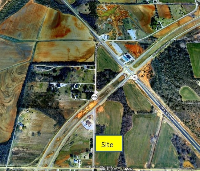
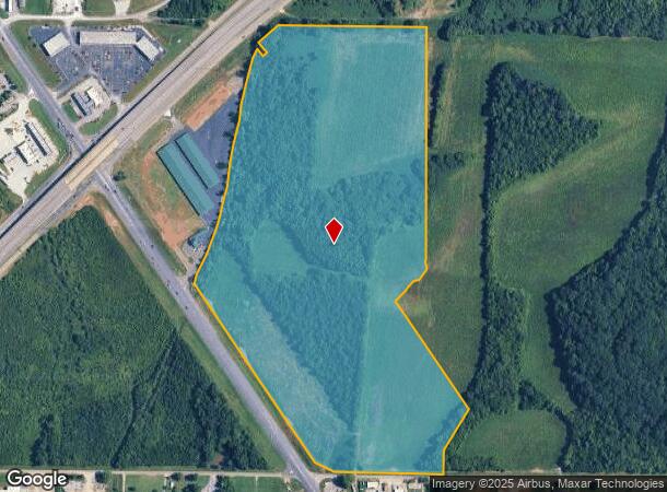
Property Record
731 Blake Bottom Rd Nw, Huntsville, AL 35806
NEARBY LISTINGS FOR SALE OR LEASE
Property Detail
731 Blake Bottom Rd Nw
Huntsville, AL
PT LOT 1 UAH PROPERTIES AT BLAKE BOTTOM RD PH 7 PB# 2023-75 BEG NWLY COR LOT 1 TH E 891 FT TH S 2610 FT TO N MAR BLAKE BOTTOM
14-03-07-0-000-023.000
Madison
Commercialacreage
Alabama
AE
1
01089C0166F
20 AC
2025
North Huntsville
2025
Huntsville
010627
DEMOGRAPHICS near 731 Blake Bottom Rd Nw
1 Mile
3 Mile
5 Mile
2024 Total Population
1,858
27,882
94,806
2029 Population
2,092
31,137
105,378
Pop Growth 2024-2029
+ 12.59%
+ 11.67%
+ 11.15%
Average Age
37
40
39
2024 Total Households
859
11,866
39,522
HH Growth 2024-2029
+ 12.57%
+ 12.31%
+ 11.80%
Median Household Inc
$91,874
$78,351
$66,662
Avg Household Size
2.20
2.20
2.20
2024 Avg HH Vehicles
2.00
2.00
2.00
Median Home Value
$292,119
$247,045
$219,921
Median Year Built
2010
2000
1988
Nearby Places
- Restaurants
- Banks
- Shops
- Fitness
- Groceries
PUBLIC TRANSPORTATION
AIRPORT
Huntsville International-Carl T Jones Field
DRIVE
WALK
Distance
Huntsville International-Carl T Jones Field
21 min
15.0 mi
Freight Ports
Port of Mobile
DRIVE
WALK
Distance
Port of Mobile
389 min
356.2 mi
Nearby Properties
Address
Land Use
TOTAL SIZE
Lot Size
Zoning
Address
Land Use
TOTAL SIZE
Lot Size
Zoning
9,056 SF
39.70 AC
Address
Land Use
TOTAL SIZE
Lot Size
Zoning
18,232 SF
19 AC
Address
Land Use
TOTAL SIZE
Lot Size
Zoning
13,345 SF
18 AC
Address
Land Use
TOTAL SIZE
Lot Size
Zoning
14,665 SF
7.40 AC
Address
Land Use
TOTAL SIZE
Lot Size
Zoning
7,384 SF
11.50 AC
Address
Land Use
TOTAL SIZE
Lot Size
Zoning
1,454 SF
14.22 AC
Address
Land Use
TOTAL SIZE
Lot Size
Zoning
3,644 SF
25.74 AC
Address
Land Use
TOTAL SIZE
Lot Size
Zoning
19,078 SF
10 AC
Address
Land Use
TOTAL SIZE
Lot Size
Zoning
11,912 SF
17 AC
Address
Land Use
TOTAL SIZE
Lot Size
Zoning
11,213 SF
5.10 AC
Address
Land Use
TOTAL SIZE
Lot Size
Zoning
2,517 SF
35 AC
Address
Land Use
TOTAL SIZE
Lot Size
Zoning
27,083 SF
0.29 AC
Address
Land Use
TOTAL SIZE
Lot Size
Zoning
1,526 SF
11.83 AC
Address
Land Use
TOTAL SIZE
Lot Size
Zoning
2,248 SF
14 AC
Address
Land Use
TOTAL SIZE
Lot Size
Zoning
120,000 SF
14.59 AC
Address
Land Use
TOTAL SIZE
Lot Size
Zoning
7,895 SF
3.58 AC
Address
Land Use
TOTAL SIZE
Lot Size
Zoning
7,600 SF
9.72 AC
Address
Land Use
TOTAL SIZE
Lot Size
Zoning
65,782 SF
12.44 AC
Address
Land Use
TOTAL SIZE
Lot Size
Zoning
139,578 SF
9.53 AC
Address
Land Use
TOTAL SIZE
Lot Size
Zoning
6,696 SF
5.19 AC
Address
Land Use
TOTAL SIZE
Lot Size
Zoning
100,000 SF
8.67 AC
Address
Land Use
TOTAL SIZE
Lot Size
Zoning
30,513 SF
16 AC
Address
Land Use
TOTAL SIZE
Lot Size
Zoning
24,000 SF
8.37 AC
Address
Land Use
TOTAL SIZE
Lot Size
Zoning
12,000 SF
8.36 AC
Address
Land Use
TOTAL SIZE
Lot Size
Zoning
6,400 SF
4.10 AC
Address
Land Use
TOTAL SIZE
Lot Size
Zoning
1,746 SF
8.90 AC
Address
Land Use
TOTAL SIZE
Lot Size
Zoning
15,311 SF
3.96 AC
Address
Land Use
TOTAL SIZE
Lot Size
Zoning
44,460 SF
8.73 AC
Address
Land Use
TOTAL SIZE
Lot Size
Zoning
35,898 SF
14 AC
Address
Land Use
TOTAL SIZE
Lot Size
Zoning
32,250 SF
6.50 AC
The World's #1 Commercial Real Estate Marketplace
Connect with us
© 2025 CoStar Group
The information above has been obtained from sources believed reliable. While we do not doubt its accuracy we have not verified it and make no guarantee, warranty or representation about it. It is your responsibility to independently confirm its accuracy and completeness. Any projections, opinions, assumptions, or estimates used are for example only and do not represent the current or future performance of the property. The value of this transaction to you depends on tax and other factors which should be evaluated by your tax, financial, and legal advisors. You and your advisors should conduct a careful, independent investigation of the property to determine to your satisfaction the suitability of the property for your needs.