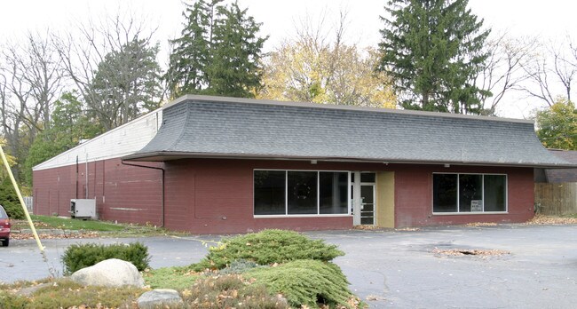
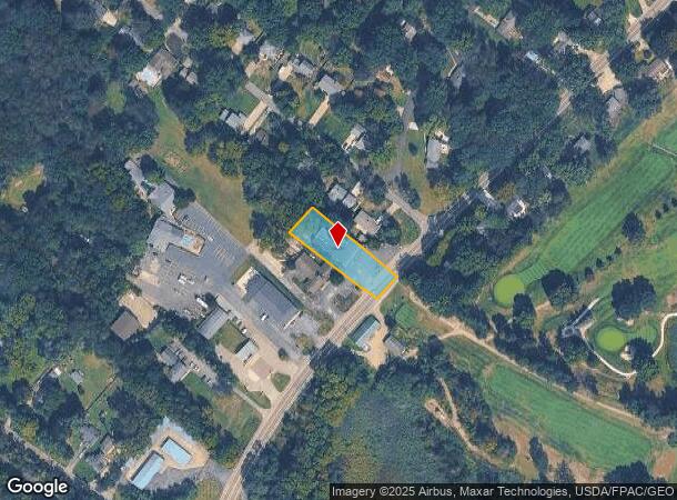
Property Record
7311 State Route 43, Kent, OH 44240
NEARBY LISTINGS FOR SALE OR LEASE
Property Detail
7311 State Route 43
Cleveland
Franklin
Akron, OH
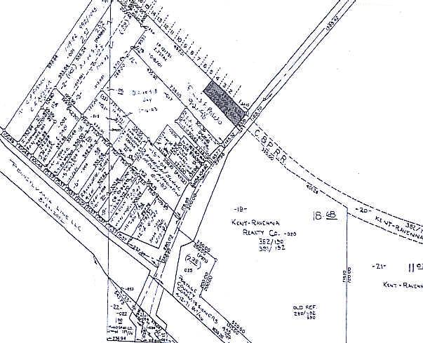
LOT 68
12-068-00-00-018-008
Portage
Storebuilding
Ohio
2024
68
2024
0.52 AC
601600
Portage County
7,370 SF
DEMOGRAPHICS near 7311 State Route 43
1 Mile
3 Mile
5 Mile
2024 Total Population
1,266
26,846
84,193
2029 Population
1,282
27,130
84,938
Pop Growth 2024-2029
+ 1.26%
+ 1.06%
+ 0.88%
Average Age
47
36
39
2024 Total Households
522
10,330
34,462
HH Growth 2024-2029
+ 0.96%
+ 1.44%
+ 1.05%
Median Household Inc
$136,197
$54,367
$64,643
Avg Household Size
2.30
2.20
2.20
2024 Avg HH Vehicles
2.00
2.00
2.00
Median Home Value
$264,325
$235,331
$207,168
Median Year Built
1963
1974
1976
Nearby Places
Map Layers
Map Styles
 Street
 Aerial
- Restaurants
- Banks
- Shops
- Fitness
- Groceries
PUBLIC TRANSPORTATION
AIRPORT
Akron-Canton Regional
DRIVE
WALK
Distance
Akron-Canton Regional
39 min
26.6 mi
Cleveland-Hopkins International
DRIVE
WALK
Distance
Cleveland-Hopkins International
60 min
41.4 mi
Nearby Properties
Address
Land Use
TOTAL SIZE
Lot Size
Zoning
Address
Land Use
TOTAL SIZE
Lot Size
Zoning
871,059 SF
404.65 AC
Address
Land Use
TOTAL SIZE
Lot Size
Zoning
183,977 SF
10.12 AC
Address
Land Use
TOTAL SIZE
Lot Size
Zoning
86,411 SF
0.23 AC
Address
Land Use
TOTAL SIZE
Lot Size
Zoning
61,748 SF
17.12 AC
Address
Land Use
TOTAL SIZE
Lot Size
Zoning
141,562 SF
1.63 AC
Address
Land Use
TOTAL SIZE
Lot Size
Zoning
117,571 SF
119.98 AC
Address
Land Use
TOTAL SIZE
Lot Size
Zoning
150,616 SF
12.63 AC
Address
Land Use
TOTAL SIZE
Lot Size
Zoning
213,347 SF
30.75 AC
Address
Land Use
TOTAL SIZE
Lot Size
Zoning
146,435 SF
59.76 AC
Address
Land Use
TOTAL SIZE
Lot Size
Zoning
8.12 AC
Address
Land Use
TOTAL SIZE
Lot Size
Zoning
28,438 SF
9 AC
Address
Land Use
TOTAL SIZE
Lot Size
Zoning
52,575 SF
1.33 AC
Address
Land Use
TOTAL SIZE
Lot Size
Zoning
89,449 SF
14.59 AC
Address
Land Use
TOTAL SIZE
Lot Size
Zoning
34,394 SF
3.59 AC
Address
Land Use
TOTAL SIZE
Lot Size
Zoning
78,446 SF
18.02 AC
Address
Land Use
TOTAL SIZE
Lot Size
Zoning
176,320 SF
1.73 AC
Address
Land Use
TOTAL SIZE
Lot Size
Zoning
33,561 SF
2.62 AC
Address
Land Use
TOTAL SIZE
Lot Size
Zoning
63,288 SF
0.88 AC
Address
Land Use
TOTAL SIZE
Lot Size
Zoning
73,306 SF
0.78 AC
Address
Land Use
TOTAL SIZE
Lot Size
Zoning
24,210 SF
2.34 AC
Address
Land Use
TOTAL SIZE
Lot Size
Zoning
158,664 SF
11.30 AC
Address
Land Use
TOTAL SIZE
Lot Size
Zoning
48,779 SF
0.55 AC
Address
Land Use
TOTAL SIZE
Lot Size
Zoning
23,668 SF
2.32 AC
Address
Land Use
TOTAL SIZE
Lot Size
Zoning
44,010 SF
13.97 AC
Address
Land Use
TOTAL SIZE
Lot Size
Zoning
178,341 SF
25.82 AC
Address
Land Use
TOTAL SIZE
Lot Size
Zoning
27,223 SF
10.85 AC
Address
Land Use
TOTAL SIZE
Lot Size
Zoning
43,705 SF
0.36 AC
Address
Land Use
TOTAL SIZE
Lot Size
Zoning
84,265 SF
11.11 AC
Address
Land Use
TOTAL SIZE
Lot Size
Zoning
63,664 SF
8.31 AC
Address
Land Use
TOTAL SIZE
Lot Size
Zoning
38,025 SF
0.21 AC
The World's #1 Commercial Real Estate Marketplace
Connect with us
© 2025 CoStar Group
The information above has been obtained from sources believed reliable. While we do not doubt its accuracy we have not verified it and make no guarantee, warranty or representation about it. It is your responsibility to independently confirm its accuracy and completeness. Any projections, opinions, assumptions, or estimates used are for example only and do not represent the current or future performance of the property. The value of this transaction to you depends on tax and other factors which should be evaluated by your tax, financial, and legal advisors. You and your advisors should conduct a careful, independent investigation of the property to determine to your satisfaction the suitability of the property for your needs.