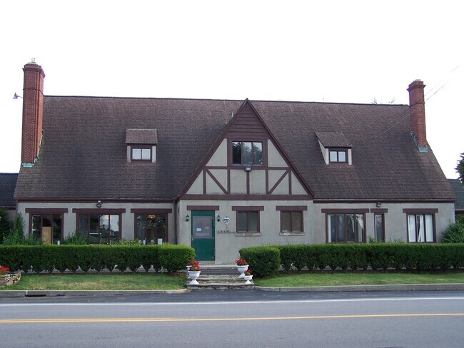
Property Record
7312 Chestnut Ridge Rd, Lockport, NY 14094

NEARBY LISTINGS FOR SALE OR LEASE
Property Detail
7312 Chestnut Ridge Rd
292600-110-002-0001-032-012
Niagara
Animalhospitalvet
New York
X
32.012
36063C0242E
1.80 AC
2025
Outlying Niagara County
2024
Buffalo/Niagara Falls
023402
Buffalo-Cheektowaga-Niagara Falls, NY
5,517 SF
DEMOGRAPHICS near 7312 Chestnut Ridge Rd
1 Mile
3 Mile
5 Mile
2024 Total Population
897
17,758
40,377
2029 Population
885
17,444
39,770
Pop Growth 2024-2029
(1.34%)
(1.77%)
(1.50%)
Average Age
45
43
42
2024 Total Households
367
7,707
17,580
HH Growth 2024-2029
(1.36%)
(1.76%)
(1.50%)
Median Household Inc
$88,636
$67,609
$61,573
Avg Household Size
2.40
2.20
2.20
2024 Avg HH Vehicles
2.00
2.00
2.00
Median Home Value
$184,615
$160,661
$147,655
Median Year Built
1972
1959
1962
Nearby Places
Map Layers
Map Styles
 Street
 Aerial
- Restaurants
- Banks
- Shops
- Fitness
- Groceries
PUBLIC TRANSPORTATION
AIRPORT
Niagara Falls International
DRIVE
WALK
Distance
Niagara Falls International
27 min
19.3 mi
Buffalo Niagara International
DRIVE
WALK
Distance
Buffalo Niagara International
29 min
20.6 mi
Freight Ports
Albany, NY Port
DRIVE
WALK
Distance
Albany, NY Port
336 min
284.4 mi
SALE & LEASE HISTORY
LISTING DATE
SALE/LEASE

Feb 07, 2020
For Sale
Nearby Properties
Address
Land Use
TOTAL SIZE
Lot Size
Zoning
Address
Land Use
TOTAL SIZE
Lot Size
Zoning
111,617 SF
16.83 AC
RA
Address
Land Use
TOTAL SIZE
Lot Size
Zoning
108,630 SF
0.77 AC
B2
Address
Land Use
TOTAL SIZE
Lot Size
Zoning
760 SF
7.82 AC
R1
Address
Land Use
TOTAL SIZE
Lot Size
Zoning
67,111 SF
3.22 AC
B2
Address
Land Use
TOTAL SIZE
Lot Size
Zoning
24,103 SF
74.12 AC
Address
Land Use
TOTAL SIZE
Lot Size
Zoning
16,282 SF
4.90 AC
R3
Address
Land Use
TOTAL SIZE
Lot Size
Zoning
92,413 SF
18.50 AC
R
Address
Land Use
TOTAL SIZE
Lot Size
Zoning
62,310 SF
6.39 AC
R3
Address
Land Use
TOTAL SIZE
Lot Size
Zoning
7,692 SF
3.82 AC
R3
Address
Land Use
TOTAL SIZE
Lot Size
Zoning
8,160 SF
4.22 AC
R3
Address
Land Use
TOTAL SIZE
Lot Size
Zoning
154,300 SF
5.93 AC
RA
Address
Land Use
TOTAL SIZE
Lot Size
Zoning
16,380 SF
3.68 AC
R3
Address
Land Use
TOTAL SIZE
Lot Size
Zoning
16,368 SF
44 AC
AR
Address
Land Use
TOTAL SIZE
Lot Size
Zoning
62,491 SF
10.74 AC
RA
Address
Land Use
TOTAL SIZE
Lot Size
Zoning
29,649 SF
2.94 AC
07 - MIXED
Address
Land Use
TOTAL SIZE
Lot Size
Zoning
14,940 SF
5.36 AC
R3
Address
Land Use
TOTAL SIZE
Lot Size
Zoning
13,846 SF
5.14 AC
R1
Address
Land Use
TOTAL SIZE
Lot Size
Zoning
93,053 SF
0.82 AC
B2
Address
Land Use
TOTAL SIZE
Lot Size
Zoning
11,317 SF
1.30 AC
Address
Land Use
TOTAL SIZE
Lot Size
Zoning
58,339 SF
5.70 AC
Address
Land Use
TOTAL SIZE
Lot Size
Zoning
4,100 SF
2.76 AC
R3
Address
Land Use
TOTAL SIZE
Lot Size
Zoning
40,564 SF
2.20 AC
B2
Address
Land Use
TOTAL SIZE
Lot Size
Zoning
216,405 SF
4.02 AC
I3
Address
Land Use
TOTAL SIZE
Lot Size
Zoning
1,592 SF
22.51 AC
R3
Address
Land Use
TOTAL SIZE
Lot Size
Zoning
4,796 SF
0.54 AC
B2
Address
Land Use
TOTAL SIZE
Lot Size
Zoning
38,500 SF
18.80 AC
Address
Land Use
TOTAL SIZE
Lot Size
Zoning
7,248 SF
26.44 AC
RA
Address
Land Use
TOTAL SIZE
Lot Size
Zoning
8,636 SF
0.70 AC
B4
Address
Land Use
TOTAL SIZE
Lot Size
Zoning
8,094 SF
4.95 AC
R3
Address
Land Use
TOTAL SIZE
Lot Size
Zoning
99,600 SF
1.12 AC
I3
The World's #1 Commercial Real Estate Marketplace
Connect with us
© 2025 CoStar Group
The information above has been obtained from sources believed reliable. While we do not doubt its accuracy we have not verified it and make no guarantee, warranty or representation about it. It is your responsibility to independently confirm its accuracy and completeness. Any projections, opinions, assumptions, or estimates used are for example only and do not represent the current or future performance of the property. The value of this transaction to you depends on tax and other factors which should be evaluated by your tax, financial, and legal advisors. You and your advisors should conduct a careful, independent investigation of the property to determine to your satisfaction the suitability of the property for your needs.